
Файл:Alexander archipelago.jpg

Размер на този преглед: 450 × 600 пиксела. Други разделителни способности: 180 × 240 пиксела | 360 × 480 пиксела | 576 × 768 пиксела | 1050 × 1400 пиксела.
Оригинален файл (1050 × 1400 пиксела, големина на файла: 529 КБ, MIME-тип: image/jpeg)
| Този файл е от Общомедия и може да се използва от други проекти.
Следва информация за файла, достъпна през оригиналната му описателна страница. |
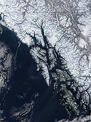
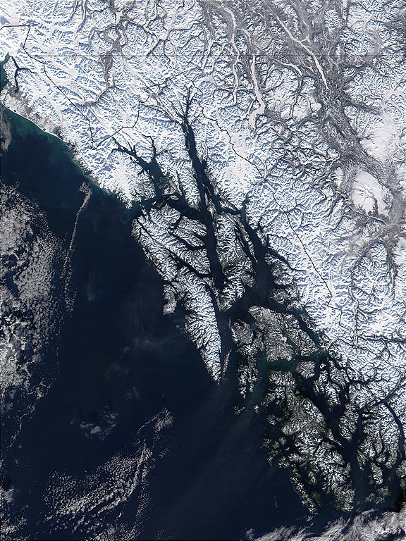
| Описание | West of British Columbia, Canada, and south of the Yukon Territory, the southeastern coastline of Alaska trails off into the islands of the Alexander Archipelago. The area is rugged and contains many long, U-shaped, glaciated valleys, many of which terminate at tidewater. The Alexander Archipelago is home to Glacier Bay National Park. The large bay that has two forks on its northern end is Glacier Bay itself. The eastern fork is Muir inlet, into which runs the Muir glacier, named for the famous Scottish-born naturalist John Muir. Glacier Bay opens up into the Icy Strait. The large, solid white area to the west is Brady Icefield, which terminates at the southern end in Brady's Glacier. |
| Дата | |
| Източник | https://visibleearth.nasa.gov/images/57719/alexander-archipelago-southeastern-alaska |
| Автор | Jacques Descloitres, MODIS Land Rapid Response Team, NASA/GSFC |
| This file is in the public domain in the United States because it was solely created by NASA. NASA copyright policy states that "NASA material is not protected by copyright unless noted". (See Template:PD-USGov, NASA copyright policy page or JPL Image Use Policy.) | ||
 |
Warnings:
|
История на файла
Избирането на дата/час ще покаже как е изглеждал файлът към онзи момент.
| Дата/Час | Миникартинка | Размер | Потребител | Коментар | |
|---|---|---|---|---|---|
| текуща | 09:32, 1 юни 2005 | | 1050 × 1400 (529 КБ) | Alib | NASA MODIS satellite image of the Alexander archipelago, Alaska |
Използване на файла
Няма страници, използващи файла.
Глобално използване на файл
Този файл се използва от следните други уикита:
- Употреба в ar.wikipedia.org
- Употреба в arz.wikipedia.org
- Употреба в ast.wikipedia.org
- Употреба в az.wikipedia.org
- Употреба в be.wikipedia.org
- Употреба в ca.wikipedia.org
- Употреба в ceb.wikipedia.org
- Употреба в cs.wikipedia.org
- Употреба в da.wikipedia.org
- Употреба в de.wikipedia.org
- Употреба в en.wikipedia.org
- Употреба в en.wikivoyage.org
- Употреба в eo.wikipedia.org
- Употреба в es.wikipedia.org
- Употреба в et.wikipedia.org
- Употреба в eu.wikipedia.org
- Употреба в fa.wikipedia.org
- Употреба в fi.wikipedia.org
- Употреба в fr.wikipedia.org
- Употреба в fy.wikipedia.org
Преглед на глобалната употреба на файла.