
Файл:Languages of CE Europe-3.PNG
Размер на този преглед: 524 × 599 пиксела. Други разделителни способности: 210 × 240 пиксела | 419 × 480 пиксела | 951 × 1088 пиксела.
Оригинален файл (951 × 1088 пиксела, големина на файла: 769 КБ, MIME-тип: image/png)
| Този файл е от Общомедия и може да се използва от други проекти.
Следва информация за файла, достъпна през оригиналната му описателна страница. |
Резюме
| Описание |
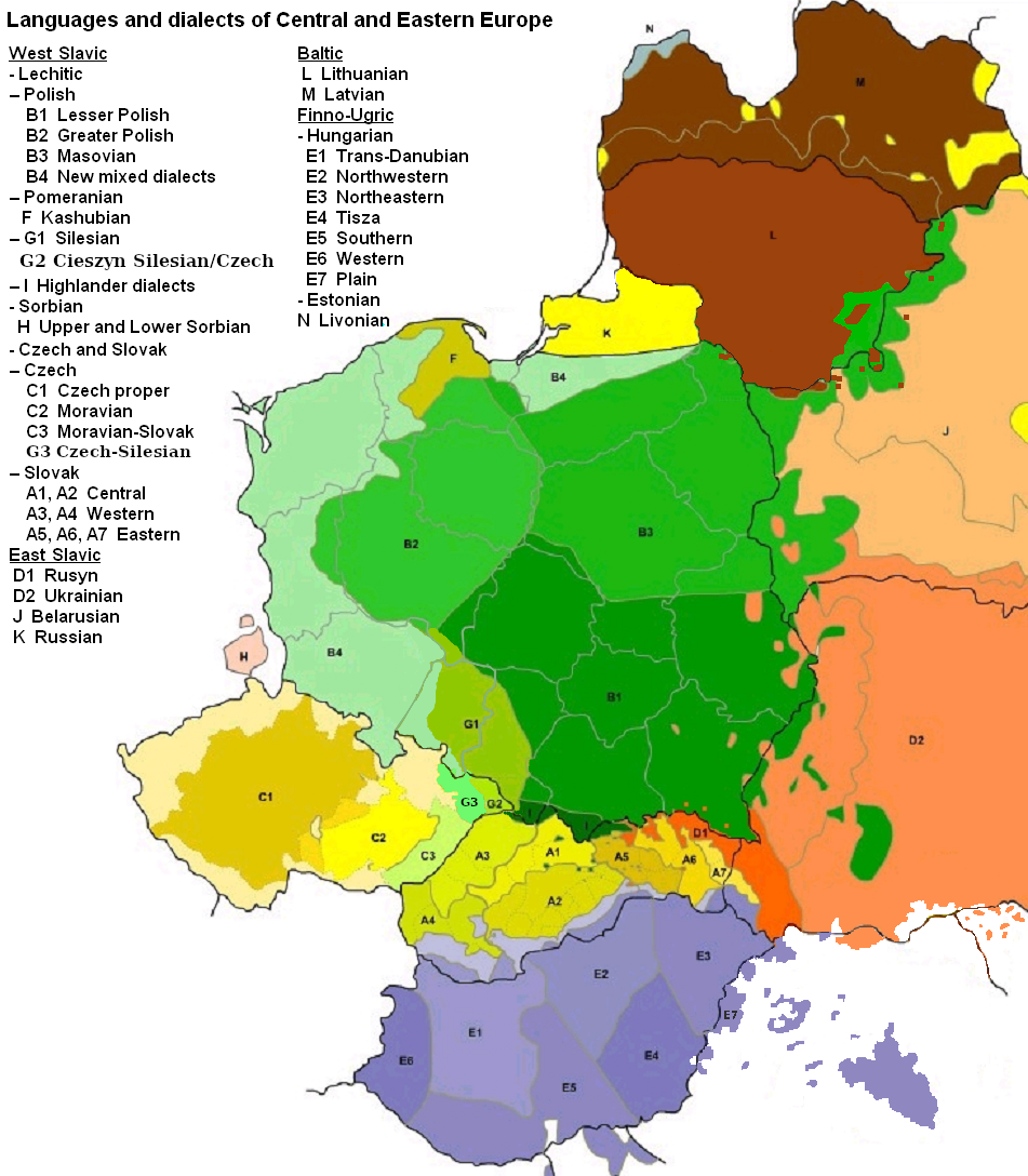
English: Map of languages and dialects of Central and Eastern Europe
Polski: Języki i dialekty Europy Srodkowo-Wschodniej
Deutsch: Legende:
|
||
| Дата | |||
| Източник |
Собствена творба |
||
| Автор | |||
| други версии |
|

|
Това изображение (или всички изображения в тази страница/категория) би трябвало да бъдат пресъздадени с използване на векторна графика във формат SVG. Това има няколко предимства; вижте Commons:Media for cleanup за повече информация. Ако разполагате с това избражение в SVG формат, моля качете го. След това заместете този шаблон с {{Vector version available|име на новия файл.svg}}.
|
Лицензиране

|
Предоставя се разрешение за копиране, разпространение и/или модификация на този документ според Лиценза за свободна документация на ГНУ, в своята версия 1.2 или някоя следваща версия, издадена от Фондацията за свободен софтуер; без непроменими раздели, без текст на предната подвързия и без текст на задната подвързия. Копие на този лиценз е приложено в раздела Лиценз за свободна документация на ГНУ. |
| Този файл се разпространява под лиценз Криейтив Комънс Признание — Споделяне на споделеното 3.0. | ||
| Признание: Zaragoza, Kpalion, Dellijks | ||
| ||
| This licensing tag was added to this file as part of the GFDL licensing update. |
Дневник на оригиналното качване
This image is a derivative work of the following images:
- File:Languages_of_CE_Europe.PNG licensed with GFDL
- 2008-08-25T20:42:18Z Kpalion 951x1088 (1053557 Bytes) {{Information |Description={{en|Map of languages and dialects of Central and Eastern Europe}} |Source=*[[:Image:Jezyki_i_dialekty_Europa_Srodkowo_Wsch..jpg|]] |Date=2008-08-25 20:40 (UTC) |Author=*derivative work: ~~~ *[[:Ima
История на файла
Избирането на дата/час ще покаже как е изглеждал файлът към онзи момент.
| Дата/Час | Миникартинка | Размер | Потребител | Коментар | |
|---|---|---|---|---|---|
| текуща | 06:47, 17 август 2019 | | 951 × 1088 (769 КБ) | D T G | G1 - changed western border (compare my other map: File:Gwary śląskie wg Zaręby.png - sources there); G2 - changed name and classification (this was part of the Polish Cieszyn Silesian, after 1920 evolving towards Czech, but it was absurd that it would be classified as Czech when to South-West was just G1, not differentiated from G1 in Poland! I repeat it was absurd!, therefore I created G3, see below); G3 - created Czech-Silesian also know as Lach dialects, up to 1980s regarded by some... |
| 07:42, 17 август 2015 |  | 951 × 1088 (928 КБ) | Winnetou14 | Reverted to version as of 19:28, 13 September 2009 | |
| 23:11, 11 ноември 2009 |  | 951 × 1088 (697 КБ) | Alex Tora | {{Information |Description= |Source={{own}} |Date= |Author=Alex Tora |Permission= |other_versions= }} | |
| 19:28, 13 септември 2009 |  | 951 × 1088 (928 КБ) | Scooter20 | Fixed Hungarian & Ukrainian in Romania, Ukrainian in Moldova and Romanian in Hungary and Ukraine | |
| 22:16, 19 юли 2009 |  | 951 × 1088 (982 КБ) | Dellijks | {{Information |Description={{en|Map of languages and dialects of Central and Eastern Europe}}{{pl|Języki i dialekty Europy Srodkowo-Wschodniej}} {{de|-> * B1 - Kleinpolnisch * B2 - Großpolnisch * B3 - Masowisch * B4 - Hochpolnisch * F - Kaschubisch * G1 |
Използване на файла
Няма страници, използващи файла.
Глобално използване на файл
Този файл се използва от следните други уикита:
- Употреба в af.wikipedia.org
- Употреба в als.wikipedia.org
- Употреба в am.wikipedia.org
- Употреба в ang.wikipedia.org
- Употреба в an.wikipedia.org
- Употреба в arz.wikipedia.org
- Употреба в ast.wikipedia.org
- Употреба в bo.wikipedia.org
- Употреба в br.wikipedia.org
- Употреба в csb.wikipedia.org
- Употреба в cs.wikipedia.org
- Употреба в cv.wikipedia.org
- Употреба в da.wikipedia.org
- Употреба в de.wikipedia.org
- Употреба в diq.wikipedia.org
- Употреба в el.wikipedia.org
- Употреба в en.wikipedia.org
- Употреба в en.wiktionary.org
- Употреба в eo.wikipedia.org
- Употреба в eu.wikipedia.org
- Употреба в frr.wikipedia.org
- Употреба в fr.wikipedia.org
- Употреба в fur.wikipedia.org
- Употреба в fy.wikipedia.org
- Употреба в gd.wikipedia.org
- Употреба в he.wikipedia.org
- Употреба в hr.wikipedia.org
- Употреба в hsb.wikipedia.org
- Употреба в hy.wikipedia.org
- Употреба в incubator.wikimedia.org
- Употреба в ka.wikipedia.org
- Употреба в ko.wikipedia.org
- Употреба в la.wikipedia.org
- Употреба в mg.wikipedia.org
- Употреба в ms.wikipedia.org
- Употреба в nl.wikipedia.org
Преглед на глобалната употреба на файла.