
Файл:Map of the Territory of the Iceni.svg

Размер на този PNG предварителен преглед на изходния SVG файл: 424 × 600 пиксела. Други разделителни способности: 170 × 240 пиксела | 339 × 480 пиксела | 543 × 768 пиксела | 724 × 1024 пиксела | 1448 × 2048 пиксела | 744 × 1052 пиксела.
Оригинален файл (Файл във формат SVG, основен размер: 744 × 1052 пиксела, големина на файла: 151 КБ)
| Този файл е от Общомедия и може да се използва от други проекти.
Следва информация за файла, достъпна през оригиналната му описателна страница. |
| Описание |
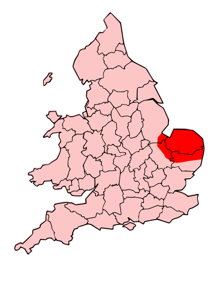
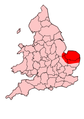
English: A map showing the territory of the Iceni tribe overlayed in red in the context of the modern county boundaries of England and wales |
| Дата | (UTC) |
| Източник | |
| Автор |
|
.svg)
.png)
| This is a retouched picture, which means that it has been digitally altered from its original version. Modifications: Revised to show extent of Iceni Territory. The original can be viewed here: Map of the Territory of the Dobunni.svg:
|
Този файл се разпространява под лиценз Криейтив Комънс Признание — Споделяне на споделеното 3.0.
- Можете свободно:
- да споделяте – да копирате, разпространявате и излъчвате произведението
- да ремиксирате – да адаптирате произведението
- Съгласно следните условия:
- признание на авторството – Трябва да посочите авторството, да добавите връзка към лиценза и да посочите дали са правени промени. Можете да направите това по всякакъв разумен начин, но не и по начин, оставящ впечатлението, че същият/същите подкрепят вас или използването по някакъв начин на творбата от вас.
- споделяне на споделеното – В случай, че промените, видоизмените или използвайки като основа произведението, го надградите, то полученото производно произведение може да се разпространява само съгласно условията на същия или съвместим лиценз с оригиналния такъв.
Дневник на оригиналното качване
This image is a derivative work of the following images:
- File:England_Celtic_tribes_-_South.png licensed with Cc-by-sa-3.0-migrated, GFDL
- 2007-11-16T12:21:48Z File Upload Bot (Magnus Manske) 550x297 (105767 Bytes) {{BotMoveToCommons|en.wikipedia}} {{Information |Description={{en|Image depicting the Celts of South England, pre-[[:en:Roman Britain]] times. I created this myself, under the guidence (to find location of them) of [http://w
- File:Map_of_the_Territory_of_the_Dobunni.svg licensed with Cc-by-sa-3.0, GFDL
- 2009-10-13T19:47:34Z Jpb1301 744x1052 (151192 Bytes) {{Information |Description={{en|1=A map showing the territory of the Dobunni tribe overlayed in red in the context of the modern county boundaries of England and wales}} |Source=*[[:File:Map_of_the_Territory_of_the_Dobunni.sv
- 2009-10-13T17:38:36Z Jpb1301 744x1052 (151194 Bytes) {{Information |Description={{en|1=A map showing the territory of the Dobunni tribe overlayed in red in the context of the modern county boundaries of England and wales}} |Source=*[[:File:Map_of_the_Territory_of_the_Cornovii_(
Uploaded with derivativeFX
История на файла
Избирането на дата/час ще покаже как е изглеждал файлът към онзи момент.
| Дата/Час | Миникартинка | Размер | Потребител | Коментар | |
|---|---|---|---|---|---|
| текуща | 19:30, 24 октомври 2009 | | 744 × 1052 (151 КБ) | Jpb1301 | {{Information |Description={{en|1=A map showing the territory of the Iceni tribe overlayed in red in the context of the modern county boundaries of England and wales}} |Source=*File:England_Celtic_tribes_-_South.png *[[:File:Map_of_the_Territory_of_ |
Използване на файла
Глобално използване на файл
Този файл се използва от следните други уикита:
- Употреба в ar.wikipedia.org
- Употреба в br.wikipedia.org
- Употреба в ca.wikipedia.org
- Употреба в da.wikipedia.org
- Употреба в en.wikipedia.org
- Употреба в es.wikipedia.org
- Употреба в fa.wikipedia.org
- Употреба в fi.wikipedia.org
- Употреба в he.wikipedia.org
- Употреба в hr.wikipedia.org
- Употреба в hy.wikipedia.org
- Употреба в id.wikipedia.org
- Употреба в it.wikipedia.org
- Употреба в ja.wikipedia.org
- Употреба в la.wikipedia.org
- Употреба в nl.wikipedia.org
- Употреба в no.wikipedia.org
- Употреба в pl.wikipedia.org
- Употреба в pt.wikipedia.org
- Употреба в ro.wikipedia.org
- Употреба в ru.wikipedia.org
- Употреба в si.wikipedia.org
- Употреба в sv.wikipedia.org
- Употреба в uk.wikipedia.org
- Употреба в ur.wikipedia.org