
Файл:Punjab 1903.gif
Punjab_1903.gif (640 × 480 пиксела, големина на файла: 338 КБ, MIME-тип: image/gif)
| Този файл е от Общомедия и може да се използва от други проекти.
Следва информация за файла, достъпна през оригиналната му описателна страница. |
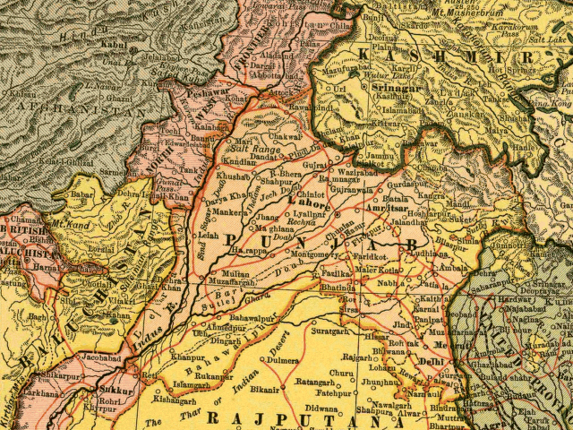
In this map, the British Raj Punjab province is colored pink, and the Indian princely states are colored yellow. As the map indicates, a number of princely states, mostly in the eastern Punjab, fell under the political authority of the British Governor of the Punjab. From map of India by Dodd, Mead and Company, 1903. Library of Congress Geography and Map Collection. Call Number G7650 1903 .D6 TIL
|
Това произведение е обществено достояние в държавите, в които срокът на авторското право е 70 години или по-малко след смъртта на автора.
| |
| This file has been identified as being free of known restrictions under copyright law, including all related and neighboring rights. | |
История на файла
Избирането на дата/час ще покаже как е изглеждал файлът към онзи момент.
| Дата/Час | Миникартинка | Размер | Потребител | Коментар | |
|---|---|---|---|---|---|
| текуща | 12:54, 6 май 2005 | | 640 × 480 (338 КБ) | Shauni | In this map, the British Raj Punjab province is colored pink, and the Indian princely states are colored yellow. As the map indicates, a number of princely states, mostly in the eastern Punjab, fell under the political authority of the British Gov |
Използване на файла
Следната страница използва следния файл:
Глобално използване на файл
Този файл се използва от следните други уикита:
- Употреба в ar.wikipedia.org
- Употреба в bn.wikipedia.org
- Употреба в br.wikipedia.org
- Употреба в ca.wikipedia.org
- Употреба в en.wikipedia.org
- Употреба в es.wikipedia.org
- Употреба в fi.wikipedia.org
- Употреба в hi.wikipedia.org
- Употреба в it.wikipedia.org
- Употреба в ko.wikipedia.org
- Употреба в ml.wikipedia.org
- Употреба в nn.wikipedia.org
- Употреба в pnb.wikipedia.org
- Употреба в ur.wikipedia.org
- Употреба в www.wikidata.org
- Употреба в zh.wikipedia.org