
Файл:ShepherdByzempire1265.jpg
Оригинален файл (1144 × 900 пиксела, големина на файла: 281 КБ, MIME-тип: image/jpeg)
| Този файл е от Общомедия и може да се използва от други проекти.
Следва информация за файла, достъпна през оригиналната му описателна страница. |
Резюме
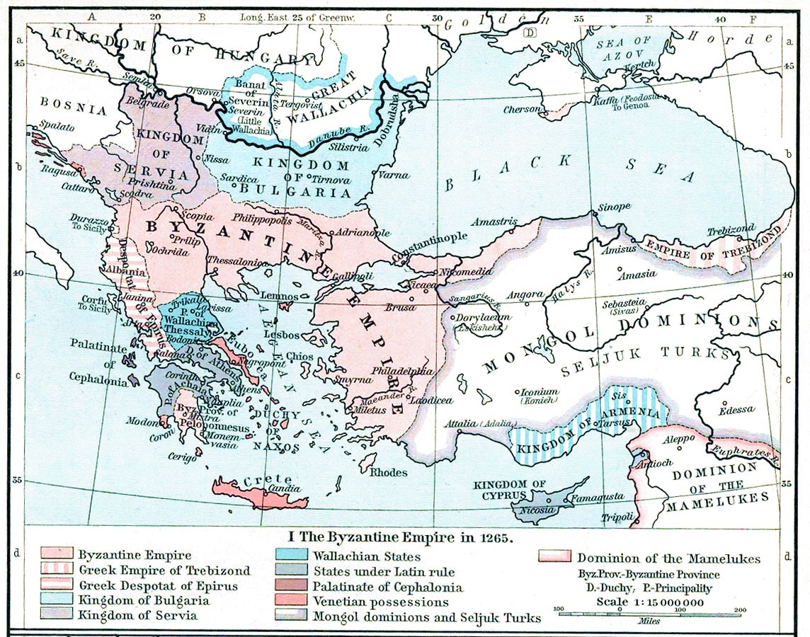
| Описание | Map, The Byzantine Empire, 1265. | ||||||||||||||||||||||
| Дата | |||||||||||||||||||||||
| Източник | The Historical Atlas, William R. Shepherd, 1911. | ||||||||||||||||||||||
| Автор |
|
||||||||||||||||||||||
| други версии |
Derivative works of this file: |
||||||||||||||||||||||

|
Това изображение (или всички изображения в тази страница/категория) би трябвало да бъдат пресъздадени с използване на векторна графика във формат SVG. Това има няколко предимства; вижте Commons:Media for cleanup за повече информация. Ако разполагате с това избражение в SVG формат, моля качете го. След това заместете този шаблон с {{Vector version available|име на новия файл.svg}}.
|


Лицензиране
|
Това произведение е обществено достояние в държавите, в които срокът на авторското право е 70 години или по-малко след смъртта на автора.
| |
| This file has been identified as being free of known restrictions under copyright law, including all related and neighboring rights. | |
This media file is in the public domain in the United States. This applies to U.S. works where the copyright has expired, often because its first publication occurred prior to January 1, 1929, and if not then due to lack of notice or renewal. See this page for further explanation.
|
 | |
 |
This image might not be in the public domain outside of the United States; this especially applies in the countries and areas that do not apply the rule of the shorter term for US works, such as Canada, Mainland China (not Hong Kong or Macao), Germany, Mexico, and Switzerland. The creator and year of publication are essential information and must be provided. See Wikipedia:Public domain and Wikipedia:Copyrights for more details.
|
История на файла
Избирането на дата/час ще покаже как е изглеждал файлът към онзи момент.
| Дата/Час | Миникартинка | Размер | Потребител | Коментар | |
|---|---|---|---|---|---|
| текуща | 15:28, 16 ноември 2022 | | 1144 × 900 (281 КБ) | Gyalu22 | Reverted to version as of 16:26, 12 July 2009 (UTC) |
| 14:49, 20 май 2016 |  | 1144 × 900 (858 КБ) | Julieta39 | Cosmetic (see discussion file) | |
| 16:26, 12 юли 2009 |  | 1144 × 900 (281 КБ) | Alex:D | whitened | |
| 16:17, 12 юли 2009 |  | 1144 × 900 (281 КБ) | Alex:D | whitened | |
| 16:12, 12 юли 2009 |  | 1144 × 900 (281 КБ) | Alex:D | whitened | |
| 13:40, 21 декември 2004 |  | 1144 × 900 (272 КБ) | Mschlindwein | Map, The Byzantine Empire, 1265. The Historical Atlas, William R. Shepherd, 1911. |
Използване на файла
Следните 4 страници използват следния файл:
Глобално използване на файл
Този файл се използва от следните други уикита:
- Употреба в an.wikipedia.org
- Употреба в ar.wikipedia.org
- Употреба в azb.wikipedia.org
- Употреба в az.wikipedia.org
- Употреба в be-tarask.wikipedia.org
- Употреба в be.wikipedia.org
- Употреба в ca.wikipedia.org
- Употреба в cs.wikipedia.org
- Употреба в de.wikipedia.org
- Употреба в el.wikipedia.org
- Употреба в en.wikipedia.org
- 1265
- Naxos
- Michael VIII Palaiologos
- Theodore II Laskaris
- Morea
- Duchy of the Archipelago
- Battle of Pelagonia
- Wikipedia:Today's featured article/April 2004
- Wikipedia:Today's featured article/April 1, 2004
- User:Rfl/FeaturedArticle
- Great Vlachia
- Kingdom of Albania (medieval)
- Talk:Cetina
- John Palaiologos (brother of Michael VIII)
Преглед на глобалната употреба на файла.