
Файл:Afghanistan region during 500 BC.jpg
Afghanistan_region_during_500_BC.jpg (348 × 347 пиксела, големина на файла: 56 КБ, MIME-тип: image/jpeg)
| Този файл е от Общомедия и може да се използва от други проекти.
Следва информация за файла, достъпна през оригиналната му описателна страница. |
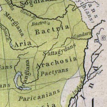
| Описание |
Español: Mapa histórico del Imperio Aqueménida.
English: Historic map of the Achaemenid Empire
Français : Carte historique de l'empire achéménide
Arachosia, Aria and Bactria were the ancient satraps of the Persian Achaemenid Empire that made up most of what is now Afghanistan and western Pakistan during 500 B.C. The main inhabitants of Arachosia were known as Pactyans, whose name possibly survives in today's Pakhtuns. |
||||
| Дата | |||||
| Източник |
http://www.lib.utexas.edu/maps/historical/history_asia.html http://www.lib.utexas.edu/maps/historical/shepherd/persian_empire.jpg |
||||
| Автор | William R. Shepherd (b. 1871 - d. 1934) | ||||
| Права (Повторно използване на файла) |
|
||||
| други версии | File:Map of the Achaemenid Empire.jpg (full) | ||||
История на файла
Избирането на дата/час ще покаже как е изглеждал файлът към онзи момент.
| Дата/Час | Миникартинка | Размер | Потребител | Коментар | |
|---|---|---|---|---|---|
| текуща | 13:48, 12 март 2010 | | 348 × 347 (56 КБ) | Officer | {{Information |Description={{es|Mapa histórico del imperio Aqueménido.}} {{en|Historic map of the Achaemenid Empire}} {{fr|Carte historique de l'empire achéménide}} |Source=http://www.lib.utexas.edu/maps/historical/history_asia.html http://www.lib.ut |
| 20:47, 21 януари 2010 |  | 324 × 357 (63 КБ) | Officer | {{Information |Description={{es|Mapa histórico del imperio Aqueménido.}} {{en|Historic map of the Achaemenid Empire}} {{fr|Carte historique de l'empire achéménide}} |Source=http://www.lib.utexas.edu/maps/historical/history_asia.html http://www.lib.ut |
Използване на файла
Следната страница използва следния файл:
Глобално използване на файл
Този файл се използва от следните други уикита:
- Употреба в am.wikipedia.org
- Употреба в ar.wikipedia.org
- Употреба в azb.wikipedia.org
- Употреба в az.wikipedia.org
- Употреба в bn.wikipedia.org
- Употреба в ca.wikipedia.org
- Употреба в de.wikipedia.org
- Употреба в en.wikipedia.org
- Употреба в eo.wikipedia.org
- Употреба в es.wikipedia.org
- Употреба в he.wikipedia.org
- Употреба в hi.wikipedia.org
- Употреба в hr.wikipedia.org
- Употреба в hy.wikipedia.org
- Употреба в id.wikipedia.org
- Употреба в it.wikipedia.org
- Употреба в ja.wikipedia.org
- Употреба в ka.wikipedia.org
- Употреба в lt.wikipedia.org
- Употреба в mn.wikipedia.org
- Употреба в pt.wikipedia.org
- Употреба в ro.wikipedia.org
- Употреба в ru.wikipedia.org
- Употреба в sh.wikipedia.org
- Употреба в sk.wikipedia.org
- Употреба в sr.wikipedia.org
- Употреба в ta.wikipedia.org
- Употреба в tg.wikipedia.org
- Употреба в uk.wikipedia.org
Преглед на глобалната употреба на файла.