
Файл:CarlSaxET1877.jpg
Оригинален файл (3100 × 2968 пиксела, големина на файла: 7,57 МБ, MIME-тип: image/jpeg)
| Този файл е от Общомедия и може да се използва от други проекти.
Следва информация за файла, достъпна през оригиналната му описателна страница. |
Резюме
| Описание |
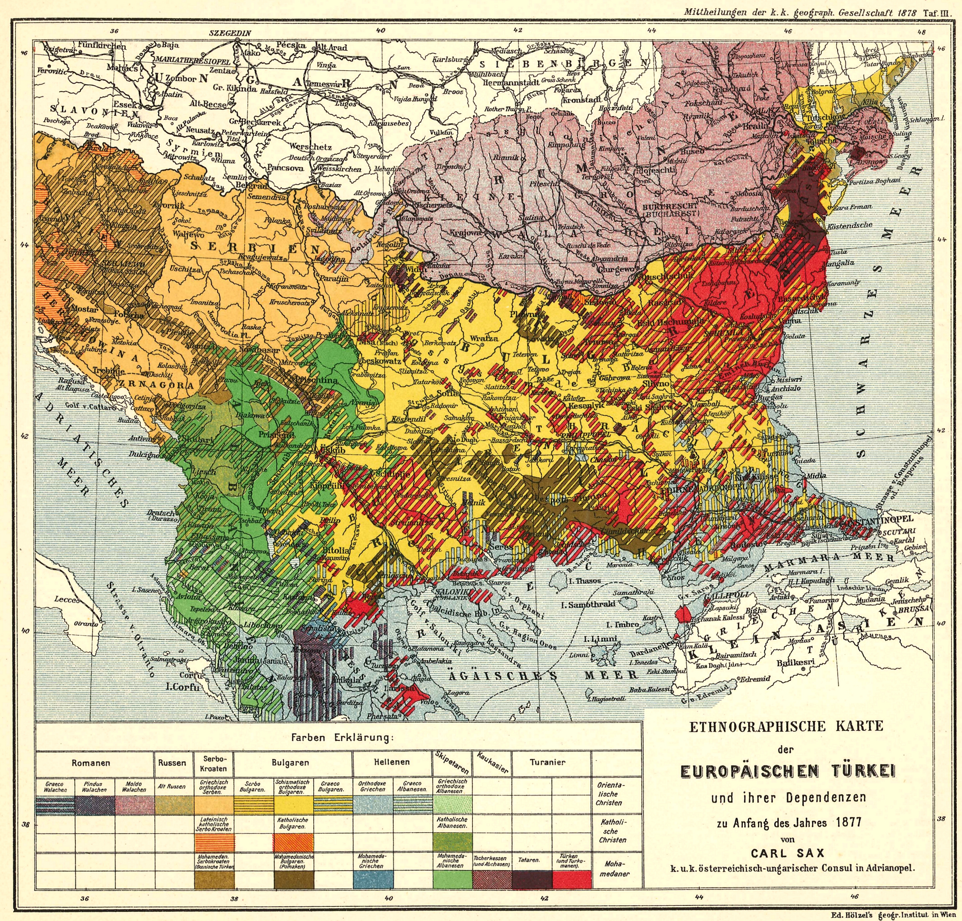
English: Ethnological Map of European Turkey and her Dependencies at the Time of the Beginning of the War of 1877, by Karl Sax, I. and R. Austro-Hungarian Consul at Adrianople. Published by the Imperial and Royal Geographical Society, Vienna 1878.
Български: Етнографска карта на Европейска Турция, автор: Карл Закс, 1877-1878 |
| Дата | 1877 - 1878 |
| Източник | The Bulgarians in their historical, ethnographical and political frontiers, 1917 |
| Автор | Carl Sax |
Лицензиране
|
Това произведение е обществено достояние в държавите, в които срокът на авторското право е 70 години или по-малко след смъртта на автора.
| |
| This file has been identified as being free of known restrictions under copyright law, including all related and neighboring rights. | |
История на файла
Избирането на дата/час ще покаже как е изглеждал файлът към онзи момент.
| Дата/Час | Миникартинка | Размер | Потребител | Коментар | |
|---|---|---|---|---|---|
| текуща | 10:04, 28 май 2008 | | 3100 × 2968 (7,57 МБ) | Alexandar.R.~commonswiki | {{Information |Description={{en|1=Ethnological Map of European Turkey and her Dependencies at the Time of the Beginning of the War of 1877, by Karl Sax, I. and R. Austro-Hungarian Consul at Adrianople. Publisched by the Imperial and Royal Geographical Soc |
Използване на файла
Следните 3 страници използват следния файл:
Глобално използване на файл
Този файл се използва от следните други уикита:
- Употреба в ba.wikipedia.org
- Употреба в cv.wikipedia.org
- Употреба в de.wikipedia.org
- Употреба в en.wikipedia.org
- Demographic history of Macedonia
- Talk:Albanians in North Macedonia
- History of the Bulgarian language
- Bulgarian Turks
- Albanians in Serbia
- Wikipedia:Articles for deletion/Log/2010 April 29
- Wikipedia:Articles for deletion/Genocide of Ottoman Turks and Muslims
- Talk:Albanians/Archive 3
- User:Falcaorib
- Circassians in Romania
- Употреба в et.wikipedia.org
- Употреба в hu.wikipedia.org
- Употреба в it.wikipedia.org
- Употреба в pnb.wikipedia.org
- Употреба в ro.wikipedia.org
- Употреба в ru.wikipedia.org
- Употреба в sq.wikipedia.org
- Употреба в sr.wikipedia.org
- Употреба в tr.wikipedia.org
- Употреба в ur.wikipedia.org