
Файл:Christian Schools in Macedonia early 20th.jpg
Размер на този преглед: 780 × 600 пиксела. Други разделителни способности: 312 × 240 пиксела | 624 × 480 пиксела | 999 × 768 пиксела | 1280 × 984 пиксела | 2000 × 1538 пиксела.
Оригинален файл (2000 × 1538 пиксела, големина на файла: 557 КБ, MIME-тип: image/jpeg)
| Този файл е от Общомедия и може да се използва от други проекти.
Следва информация за файла, достъпна през оригиналната му описателна страница. |
Резюме
| Описание |
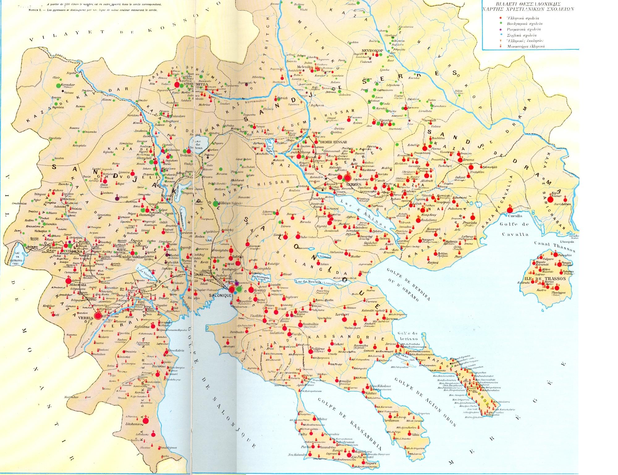
English: Map of the Italian Instituto Geografico de Agostini, showing the distribution of schools, churches, monasteries in the Ottoman vilayet of Saloniki.
Ελληνικά: Χάρτης με τα χριστιανικά σχολεία, εκκλησίες, μοναστήρια του βιλαετίου της Θεσσαλονίκης το 1903. |
| Дата | |
| Източник | Ιστορία του Ελληνικού Έθνους. Εκδοτική Αθηνών, Αθήνα 1978. ISBN 960-213-110-1, σελ. 228-229 |
| Автор | Άγνωστος/Unknown |
| Права (Повторно използване на файла) |
δείτε παρακάτω |
Лицензиране
This media file is in the public domain in the United States. This applies to U.S. works where the copyright has expired, often because its first publication occurred prior to January 1, 1929, and if not then due to lack of notice or renewal. See this page for further explanation.
|
 | |
 |
This image might not be in the public domain outside of the United States; this especially applies in the countries and areas that do not apply the rule of the shorter term for US works, such as Canada, Mainland China (not Hong Kong or Macao), Germany, Mexico, and Switzerland. The creator and year of publication are essential information and must be provided. See Wikipedia:Public domain and Wikipedia:Copyrights for more details.
|
История на файла
Избирането на дата/час ще покаже как е изглеждал файлът към онзи момент.
| Дата/Час | Миникартинка | Размер | Потребител | Коментар | |
|---|---|---|---|---|---|
| текуща | 14:51, 25 юли 2010 | | 2000 × 1538 (557 КБ) | Alexikoua | {{Information |Description={{en|1=Map of the Italian Instituto Geografico de Agostini, showing the distribution of schools, churches, monasteries in the Ottoman vilayet of Saloniki.}} {{el|1=Χάρτης με τα χριστιανικά σχολεία, ε |
Използване на файла
Следната страница използва следния файл:
Глобално използване на файл
Този файл се използва от следните други уикита:
- Употреба в en.wikipedia.org
- Употреба в es.wikipedia.org
- Употреба в fr.wikipedia.org
- Употреба в pt.wikipedia.org
- Употреба в sr.wikipedia.org