Файл:Comparison satellite navigation orbits.svg

Съдържанието на страницата не се поддържа на други езици.
от Уикипедия, свободната енциклопедия

Оригинален файл(Файл във формат SVG, основен размер: 512 × 512 пиксела, големина на файла: 42 КБ)

Визуализиране на това изображение на .
Емблемата на Общомедия Този файл е от Общомедия и може да се използва от други проекти.

Следва информация за файла, достъпна през оригиналната му описателна страница.

This image is an animated SVG file. The .png preview above created by RSVG for use in Wikimedia is not animated and may be incomplete or incorrect. To see the animation, open media:Comparison satellite navigation orbits.svg. It should run in any modern browser or viewer. Recent versions of Chrome, Firefox, Microsoft Edge, Safari, and Opera all support SVG animated with SMIL. Other SVG animations can be found at Category:Animated SVG files.

Templates:Animated SVG/I18n
العربية | Boarisch | বাংলা | català | čeština | Deutsch | Deutsch (Sie-Form)‎ | English | español | فارسی | suomi | français | galego | עברית | हिन्दी | magyar | հայերեն | íslenska | italiano | 日本語 | 한국어 | lietuvių | македонски | മലയാളം | Plattdüütsch | Nederlands | occitan | português | português do Brasil | русский | sicilianu | slovenščina | svenska | ไทย | українська | 中文 | 中文(简体)‎ | 中文(繁體)‎ | +/−

Резюме

Описание
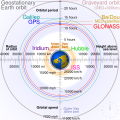
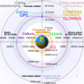
English: Comparison of GPS, GLONASS, Galileo and COMPASS (medium Earth orbit satellites) orbits with International Space Station, Hubble Space Telescope, geostationary and graveyard orbits, and the nominal size of the Earth.


For this diagram, the 3-dimensional aspect of orbits have been flattened. For instance, the view of the Earth depicted is looking down to the North Pole which makes the orbit representations appear to be equatorial. While this is accurate for geostationary orbits, other orbits listed are actually at significant inclinations. The inclination of Iridium orbits is at 86.4° which is nearly perpendicular to the diagrammed plane. Looking down to the North Pole from this zenith, a polar orbit of 90° inclination would actually appear as a straight line.
Français : Comparaison des orbites GPS, GLONASS, Galileo, Iridium et Beidou avec celles de la Station spatiale internationale et Hubble ainsi que l'orbite géostationnaire, l'orbite de rebut et la taille de la Terre.


Pour ce diagramme, l'aspect tridimensionnel des orbites a été ignoré : tout est aplati. La Terre est représentée avec le pôle Nord au centre, ce qui fait que les orbites semblent équatoriales. Ceci est correct dans le cas des orbites géostationnaires, mais les autres sont en réalité inclinées. Les satellites Iridium sont le cas le plus extrême, avec 86,4° d'inclinaison, les plaçant presque à la perpendiculaire du plan représenté. Si leur orbite était représentée de façon fidèle, nous ne verrions qu'une ligne droite sur ce diagramme.
Източник Собствена творба
Автор cmglee
други версии

[редактиране]

English: Animated
Español: Animada
Македонски: Анимирано
Русский: Мультипликация
Українська: Анімація
English: Static
Македонски: Обична слика
Русский: Обычная картинка
Українська: Статичне зображення
SVG развитие
InfoField
 
Кодът на това SVG е валиден.
 
This diagram was created with unknown tool.
 
 This diagram is translated using SVG switch elements: all translations are stored in the same file.

Assessment

Media of the day This file was selected as the media of the day for 12 August 2020. It was captioned as follows:
English: A detailed and informative diagram that brings to life where different satellites (e.g. the International Space Station vs. the GPS satellites) are physically located relative to Earth
Other languages
Čeština: Detailní diagram ukazující, kde se na oběžné dráze kolem Země fyzicky nacházejí různé uměle vyrobené satelity, např. Mezinárodní vesmírná stanice nebo součásti sysému GPS.
English: A detailed and informative diagram that brings to life where different satellites (e.g. the International Space Station vs. the GPS satellites) are physically located relative to Earth
Français : Diagramme animé présentant les principales orbites des satellites artificiels autour de la Terre.

Featured media
This is a featured media on Wikimedia Commons and is considered one of the finest files.

If you have a file of similar quality that can be published under a suitable copyright license, be sure to upload it, tag it, and nominate it.

Уикипедия

 This is a featured picture on the English language Wikipedia (Featured pictures) and is considered one of the finest images. See its nomination here.

If you think this file should be featured on Wikimedia Commons as well, feel free to nominate it.
If you have an image of similar quality that can be published under a suitable copyright license, be sure to upload it, tag it, and nominate it.

Лицензиране

Аз, носителят на авторските права над тази творба, я публикувам тук под следните лицензи:
w:bg:Криейтив Комънс
признание на авторството споделяне на споделеното
Този файл се разпространява под лиценз Криейтив Комънс Признание — Споделяне на споделеното 3.0.
Можете свободно:
  • да споделяте – да копирате, разпространявате и излъчвате произведението
  • да ремиксирате – да адаптирате произведението
Съгласно следните условия:
  • признание на авторството – Трябва да посочите авторството, да добавите връзка към лиценза и да посочите дали са правени промени. Можете да направите това по всякакъв разумен начин, но не и по начин, оставящ впечатлението, че същият/същите подкрепят вас или използването по някакъв начин на творбата от вас.
  • споделяне на споделеното – В случай, че промените, видоизмените или използвайки като основа произведението, го надградите, то полученото производно произведение може да се разпространява само съгласно условията на същия или съвместим лиценз с оригиналния такъв.
GNU head Предоставя се разрешение за копиране, разпространение и/или модификация на този документ според Лиценза за свободна документация на ГНУ, в своята версия 1.2 или някоя следваща версия, издадена от Фондацията за свободен софтуер; без непроменими раздели, без текст на предната подвързия и без текст на задната подвързия. Копие на този лиценз е приложено в раздела Лиценз за свободна документация на ГНУ.
Можете да изберете лиценз по Ваш избор.
Annotations
InfoField
This image is annotated: View the annotations at Commons

Описания

Add a one-line explanation of what this file represents
Earth satellite orbits

Някаква стойност без обект в Уикиданни

copyright status английски

copyrighted английски

source of file английски

original creation by uploader английски

MIME type английски

image/svg+xml

checksum английски

2cf5d382b563a0eac7ecd7322d221f0fb0d6bbbb

data size английски

43 502 Байт

512 пиксел

512 пиксел

История на файла

Избирането на дата/час ще покаже как е изглеждал файлът към онзи момент.

(най-нови | най-стари) Преглед (по-нови 10 | ) (10 | 20 | 50 | 100 | 250 | 500).
Дата/ЧасМиникартинкаРазмерПотребителКоментар
текуща04:48, 27 февруари 2021Миникартинка на версията към 04:48, 27 февруари 2021512 × 512 (42 КБ)GlrxFix SVG errors: systemLanguage attr on desc element; misuse of switch element; use SVG 2.0 rules; delete DOCTYPE
14:49, 24 септември 2020Миникартинка на версията към 14:49, 24 септември 2020512 × 512 (43 КБ)DrhymeFile uploaded using svgtranslate tool (https://svgtranslate.toolforge.org/). Added translation for ko.
14:44, 24 септември 2020Миникартинка на версията към 14:44, 24 септември 2020512 × 512 (40 КБ)DrhymeFile uploaded using svgtranslate tool (https://svgtranslate.toolforge.org/). Added translation for ko.
14:35, 24 септември 2020Миникартинка на версията към 14:35, 24 септември 2020512 × 512 (36 КБ)DrhymeFile uploaded using svgtranslate tool (https://svgtranslate.toolforge.org/). Added translation for ko.
19:41, 22 септември 2020Миникартинка на версията към 19:41, 22 септември 2020512 × 512 (29 КБ)CmgleeReverted to version as of 18:10, 19 August 2020 (UTC) as text is now misaligned and descriptions are removed
11:31, 21 септември 2020Миникартинка на версията към 11:31, 21 септември 2020512 × 512 (23 КБ)Leonel SohnsValid SVG.
18:10, 19 август 2020Миникартинка на версията към 18:10, 19 август 2020512 × 512 (29 КБ)RavenpuffSpecify supplementary systemLanguage="en" in switch tags as per Commons guidance
01:11, 19 август 2020Миникартинка на версията към 01:11, 19 август 2020512 × 512 (25 КБ)CmgleeFix broken hover effects and redundant text.
17:55, 30 юни 2020Миникартинка на версията към 17:55, 30 юни 2020512 × 512 (33 КБ)Galaktoschange http: to https: (except in doctype or xmlns) and wikipedia.org to en.wikipedia.org
19:43, 23 юни 2020Миникартинка на версията към 19:43, 23 юни 2020512 × 512 (33 КБ)CmgleeTry again
(най-нови | най-стари) Преглед (по-нови 10 | ) (10 | 20 | 50 | 100 | 250 | 500).

Следната страница използва следния файл:

Глобално използване на файл

Този файл се използва от следните други уикита:

Преглед на глобалната употреба на файла.

Метаданни