
Файл:East-Hem 800ad.jpg

Оригинален файл (3240 × 1903 пиксела, големина на файла: 3,51 МБ, MIME-тип: image/jpeg)
| Този файл е от Общомедия и може да се използва от други проекти.
Следва информация за файла, достъпна през оригиналната му описателна страница. |

|
Това изображение (или всички изображения в тази страница/категория) би трябвало да бъдат пресъздадени с използване на векторна графика във формат SVG. Това има няколко предимства; вижте Commons:Media for cleanup за повече информация. Ако разполагате с това избражение в SVG формат, моля качете го. След това заместете този шаблон с {{Vector version available|име на новия файл.svg}}.
|


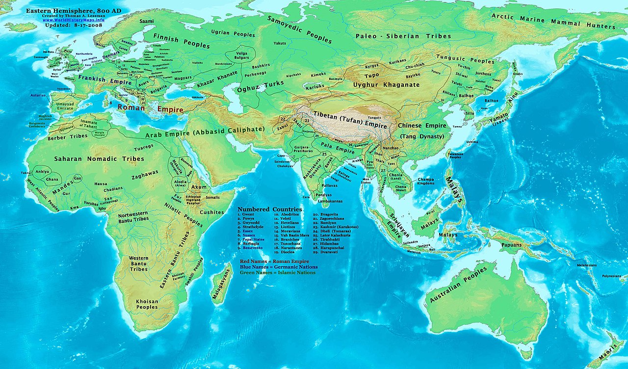
| Описание | Eastern Hemisphere in 800 AD. |
| Източник | self-made (For reference information, see the Map Source References section below.) |
| Автор | Thomas Lessman (Contact!) |
| Права (Повторно използване на файла) |
Аз, носителят на авторските права над тази творба, я публикувам тук под следния лиценз: Този файл се разпространява под лиценз Криейтив Комънс Признание — Споделяне на споделеното 3.0.
|
| други версии | see East-Hem_800ad.jpg file history on Wikipedia. |
Map Summary
Original Source URL: http://www.thomaslessman.com/History/images/East-Hem_800ad.jpg.
This map of the Eastern Hemisphere in 800 AD was created by Thomas Lessman, based on information from the sources listed below. This map is free for educational use (see Permission info above). When using this map, please mention that it is available for free at www.WorldHistoryMaps.info.
Map Source References
Remember, sources often conflict with each other. This map is only as accurate as the information that is available to me. To report any errors or to help further this work, please click here, or email Thomas Lessman at talessman@yis.us
References for information contained in this map:
1. Borders of Europe were mostly derived from the "Euratlas.com" map of Europe in 800 AD.
- (Please note: User:Bogomolov.PL has done a great job of showing me possible discrepancies in my north European borders compared to this source, due to the differences in the geographical layout of the maps.)
2. Asian information is mostly derived from the following sources:
- 2a. Wikimedia's The world in 750 CE and the World 820CE, created by User:Briangotts.
- 2b. Map of Asia in 750 AD, from Huhai.net.
- Please note: borders between Tibet and India are in question due to conflicts between source information:
- 2c. My depiction of Tibet's borders with India are based on these sources:
- 1: DK Atlas of World History (2000 edition, pg. 262), showing Tibet's borders in 800 AD, with northern India (the entire length of the Ganges, almost to the Indus river) under Tibet's control.
- 2: Huhai.net's map of Asia in 750 AD, which shows Tibetan control over Kamarupa, Bengal, and Pala.
- 3: "Himalayan Region, 500–1000 A.D." in Timeline of Art History. New York: The Metropolitan Museum of Art, (October 2001)
- 4: Google Book's "History of Tibet" (Page 54), makes several notes of Nepal's Licchavi dynasty as vassals of Tibet, and also says that India's Pala Empire under King Dharmapala accepted Tibetan overlordship.
- 5: Google Book's "Ancient India", (Page 632), describes Tibetan activities during the reigns of Songtsan Gampo and King Harsha of Kannauj. Also describes the Tibetan subjucation of Kamarupa and Kannauj after the death of King Harsha.
- 6: Wikipedia's article about Tibetan King Songtsän Gampo states that Tibet and Nepal invaded India in 648 AD and defeated Harsha's successor, after the Indian King had attacked a Chinese envoy named Wang Xuanze. (That statement referenced with Stein, R. A. Tibetan Civilization 1962. Revised English edition, 1972, Faber & Faber, London. Reprint, 1972. Stanford University Press, p. 62. ISBN 0-8047-0806-1 cloth; ISBN 0-8047-0901-7 pbk., pp. 58-59)
- Possible alternative borders for Indias Kamarupa, Gauda, Tripura, and Manipur can be seen on Porikolpok_Oxom's map of Kamarupa 7th-8th Century AD.
3. Much of the information in this map was cross-checked with Bruce Gordon's Regnal Chronologies.
Other Maps in this Series:
| Maps of the eastern hemisphere showing history
Bold dates are available on Wikimedia or Wikipedia. | ||
| Primeval | ||
| Ancient
|
·| 600 BC | 550 BC | 527 BC | 500 BC |
400 BC | ·| 1 AD | 50 AD | 100 AD | 200 AD | 300 AD | | |
| Medieval |
·| 500 AD | 565 AD | 600 AD | 700 AD | | |
| Modern |
·| 1500 AD | · * For historical maps of the whole world, | |
Other Info
История на файла
Избирането на дата/час ще покаже как е изглеждал файлът към онзи момент.
| Дата/Час | Миникартинка | Размер | Потребител | Коментар | |
|---|---|---|---|---|---|
| текуща | 09:20, 16 април 2009 | | 3240 × 1903 (3,51 МБ) | Ukabia | Added Igbo. |
| 22:46, 18 август 2008 |  | 3240 × 1903 (938 КБ) | Talessman | Updated information on Asia & Africa. Corrected some information for India, Arab Empire, Europe, etc. | |
| 20:23, 9 май 2008 |  | 3240 × 1903 (749 КБ) | Talessman | {{Information |Description=East Hemisphere in 800 AD |Source=self-made |Author= Talessman |Permission={{self|cc-by-sa-3.0}} }} |
Използване на файла
Следните 2 страници използват следния файл:
Глобално използване на файл
Този файл се използва от следните други уикита:
- Употреба в an.wikipedia.org
- Употреба в ar.wikipedia.org
- Употреба в arz.wikipedia.org
- Употреба в ast.wikipedia.org
- Употреба в azb.wikipedia.org
- Употреба в ba.wikipedia.org
- Употреба в bs.wikipedia.org
- Употреба в ca.wikipedia.org
- Употреба в cs.wikipedia.org
- Употреба в da.wikipedia.org
- Употреба в de.wikipedia.org
- Употреба в de.wikiversity.org
- Употреба в el.wikipedia.org
- Употреба в en.wikipedia.org
- 9th century
- History of the Khitans
- Proto-Mongols
- Tuvans
- Pyu city-states
- Turkic migration
- Portal:China/Anniversaries/November
- Portal:China/Anniversaries/November/November 20
- Nomadic empire
- Rashtrakuta literature
- User:Tompw/sandbox10
- Post-classical history
- File:Tibet 800ad.jpg
- User:Talessman/Maps
- User talk:Talessman/Maps
- Tibetan Empire
- History of Tuva
- History of the Uyghur people
- History of Champa
- User:Benjamin Trovato/sandbox
- Tang Standing Horse figure, Canberra
- User:Falcaorib
- Употреба в es.wikipedia.org
- Употреба в et.wikipedia.org
- Употреба в fa.wikipedia.org
Преглед на глобалната употреба на файла.