
Файл:Frankish kingdoms in 628.jpg

Оригинален файл (1239 × 1149 пиксела, големина на файла: 355 КБ, MIME-тип: image/jpeg)
| Този файл е от Общомедия и може да се използва от други проекти.
Следва информация за файла, достъпна през оригиналната му описателна страница. |
Резюме
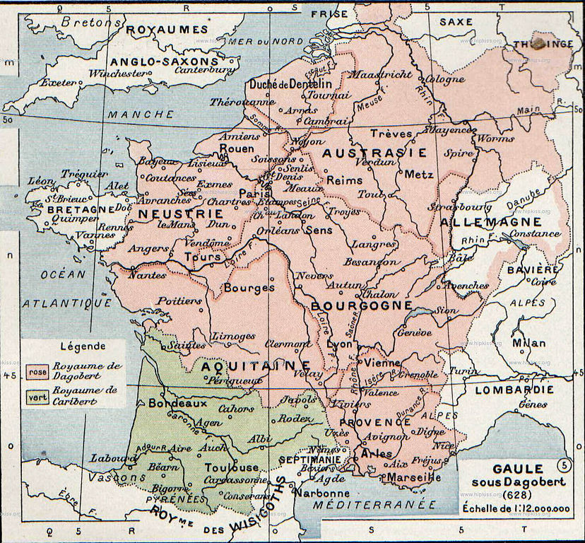
| Описание |
English: The map comes from Vidal-Lablache, Atlas général d'histoire et de géographie (1894). It shows the Frankish kingdoms in 628 AD.
Français : Gaule sous Dagobert (628). Paul Vidal de La Blache, Atlas général d'histoire et de géographie (1894). |
||||||||||||||||||||
| Дата | |||||||||||||||||||||
| Източник | Paul Vidal de La Blache, Atlas général d'histoire et de géographie (1894). | ||||||||||||||||||||
| Автор |
|
||||||||||||||||||||

Лицензиране
This image is in the public domain because it is a mere mechanical scan or photocopy of a public domain original, or – from the available evidence – is so similar to such a scan or photocopy that no copyright protection can be expected to arise. The original itself is in the public domain for the following reason:
This tag is designed for use where there may be a need to assert that any enhancements (eg brightness, contrast, colour-matching, sharpening) are in themselves insufficiently creative to generate a new copyright. It can be used where it is unknown whether any enhancements have been made, as well as when the enhancements are clear but insufficient. For known raw unenhanced scans you can use an appropriate {{PD-old}} tag instead. For usage, see Commons:When to use the PD-scan tag.  | ||||
Дневник на оригиналното качване
- 2007-08-19 21:37 Srnec 1239×1149×8 (363198 bytes) The map comes from Vidal-Lablache, ''Atlas général d'histoire et de géographie'' (1894). {{PD-art-life-70}}
История на файла
Избирането на дата/час ще покаже как е изглеждал файлът към онзи момент.
| Дата/Час | Миникартинка | Размер | Потребител | Коментар | |
|---|---|---|---|---|---|
| текуща | 20:19, 26 ноември 2007 | | 1239 × 1149 (355 КБ) | Obersachse | {{Information |Description={{en|The map comes from Vidal-Lablache, ''Atlas général d'histoire et de géographie'' (1894).}} |Source=Transfered from [http://en.wikipedia.org en.wikipedia] |Date=2007-08-19 (original upload date) |Author=Original uploader |
Използване на файла
Следните 3 страници използват следния файл:
Глобално използване на файл
Този файл се използва от следните други уикита:
- Употреба в af.wikipedia.org
- Употреба в als.wikipedia.org
- Употреба в arz.wikipedia.org
- Употреба в azb.wikipedia.org
- Употреба в be.wikipedia.org
- Употреба в br.wikipedia.org
- Употреба в ca.wikipedia.org
- Употреба в de.wikipedia.org
- Употреба в el.wikipedia.org
- Употреба в en.wikipedia.org
- Употреба в eo.wikipedia.org
- Употреба в es.wikipedia.org
- Употреба в eu.wikipedia.org
- Употреба в fr.wikipedia.org
- Употреба в gl.wikipedia.org
- Употреба в he.wikipedia.org
- Употреба в hy.wikipedia.org
- Употреба в id.wikipedia.org
- Употреба в it.wikipedia.org
- Употреба в ko.wikipedia.org
- Употреба в nl.wikipedia.org
- Употреба в pt.wikipedia.org
- Употреба в ru.wikipedia.org
Преглед на глобалната употреба на файла.