
Файл:Gallia cisalpina - Shepherd png.png

Оригинален файл (1722 × 882 пиксела, големина на файла: 3,64 МБ, MIME-тип: image/png)
| Този файл е от Общомедия и може да се използва от други проекти.
Следва информация за файла, достъпна през оригиналната му описателна страница. |
Резюме
| Описание |
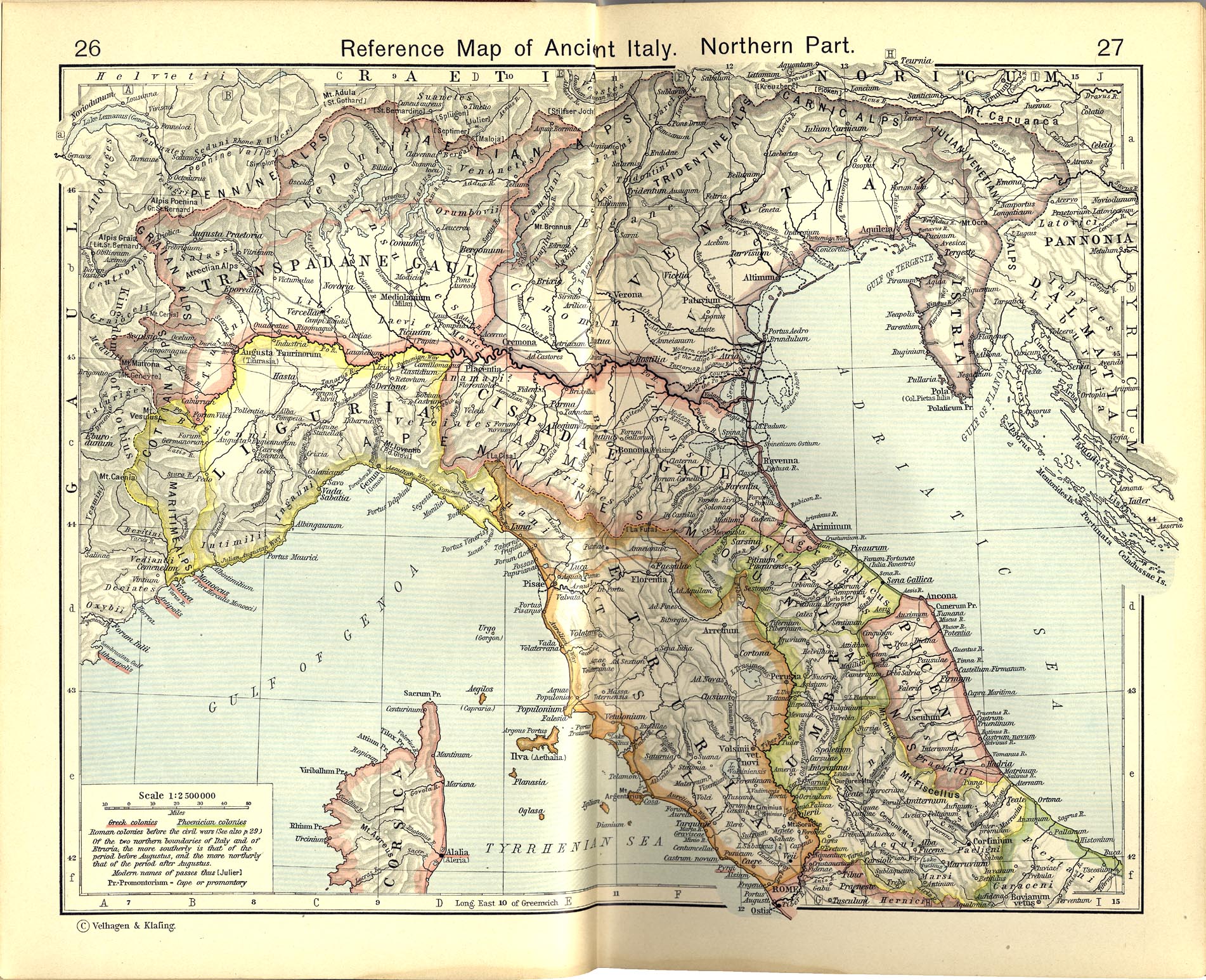
Italiano: Territori della Gallia cisalpina attorno agli inizi del I secolo a.C.
Historical Atlas by William R. Shepherd, 1911. Courtesy of the University of Texas Libraries, The University of Texas at Austin. From The Historical Atlas by William R. Shepherd, 1911 edition |
|||||
| Дата | ||||||
| Източник | File:Shepherd Map of Ancient Italy, Northern Part.jpg | |||||
| Автор |
Historical Atlas by William R. Shepherd 1911 edition
Reference: Reference Map of Ancient Italy, Northern Part Courtesy of the University of Texas Libraries, The University of Texas at Austin. [1] |
|||||
| Права (Повторно използване на файла) |
|
|||||

![[1]](http://www.lib.utexas.edu/maps/historical/shepherd/italy_ancient_south.jpg)
Дневник на оригиналното качване
This image is a derivative work of the following images:File:Shepherd Map of Ancient Italy, Northern Part.jpg
10:05, 2007 July 1 user:Accurimbono . . (366 bytes) (+366) . . (== Summary == Map of South Italy during the Roman period. Extracted from The Historical Atlas by William R. Shepherd, 1911. Original image is at http://www.lib.utexas.edu/maps/historical/shepherd_1911/shepherd-c-026-027.jpg
This media file is in the public domain in the United States. This applies to U.S. works where the copyright has expired, often because its first publication occurred prior to January 1, 1929, and if not then due to lack of notice or renewal. See this page for further explanation.
|
 | |
 |
This image might not be in the public domain outside of the United States; this especially applies in the countries and areas that do not apply the rule of the shorter term for US works, such as Canada, Mainland China (not Hong Kong or Macao), Germany, Mexico, and Switzerland. The creator and year of publication are essential information and must be provided. See Wikipedia:Public domain and Wikipedia:Copyrights for more details.
|
История на файла
Избирането на дата/час ще покаже как е изглеждал файлът към онзи момент.
| Дата/Час | Миникартинка | Размер | Потребител | Коментар | |
|---|---|---|---|---|---|
| текуща | 11:32, 9 ноември 2012 | | 1722 × 882 (3,64 МБ) | Cristiano64 | Gallia Cisalpina included also (in I century BC): Liguria and Venetia |
| 07:28, 15 октомври 2012 |  | 1722 × 882 (3,67 МБ) | Cristiano64 | User created page with UploadWizard |
Използване на файла
Следната страница използва следния файл:
Глобално използване на файл
Този файл се използва от следните други уикита:
- Употреба в ca.wikipedia.org
- Употреба в da.wikipedia.org
- Употреба в en.wikipedia.org
- Употреба в et.wikipedia.org
- Употреба в fa.wikipedia.org
- Употреба в fi.wikipedia.org
- Употреба в fr.wikipedia.org
- Употреба в hu.wikipedia.org
- Употреба в it.wikipedia.org
- Употреба в ja.wikipedia.org
- Употреба в pt.wikipedia.org
- Употреба в sh.wikipedia.org
- Употреба в www.wikidata.org