
Файл:Ionian Islands.svg

Размер на този PNG предварителен преглед на изходния SVG файл: 532 × 547 пиксела. Други разделителни способности: 233 × 240 пиксела | 467 × 480 пиксела | 747 × 768 пиксела | 996 × 1024 пиксела | 1992 × 2048 пиксела.
Оригинален файл (Файл във формат SVG, основен размер: 532 × 547 пиксела, големина на файла: 281 КБ)
| Този файл е от Общомедия и може да се използва от други проекти.
Следва информация за файла, достъпна през оригиналната му описателна страница. |

|
This map has been uploaded by Electionworld from en.wikipedia.org to enable the |
Резюме
| Описание |
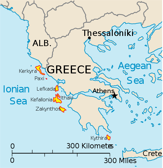
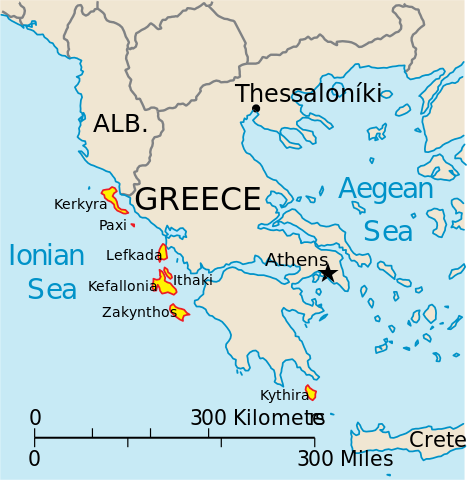
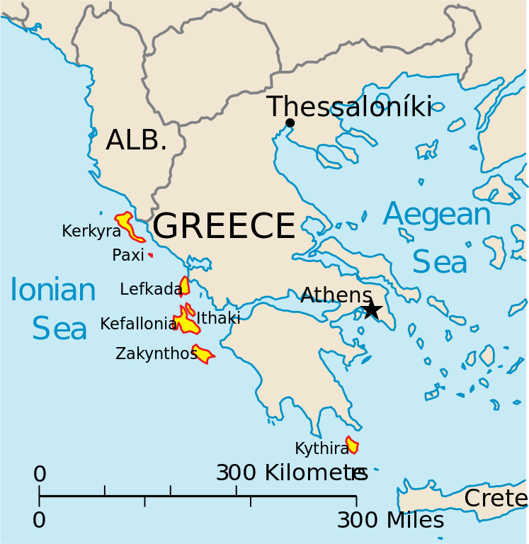
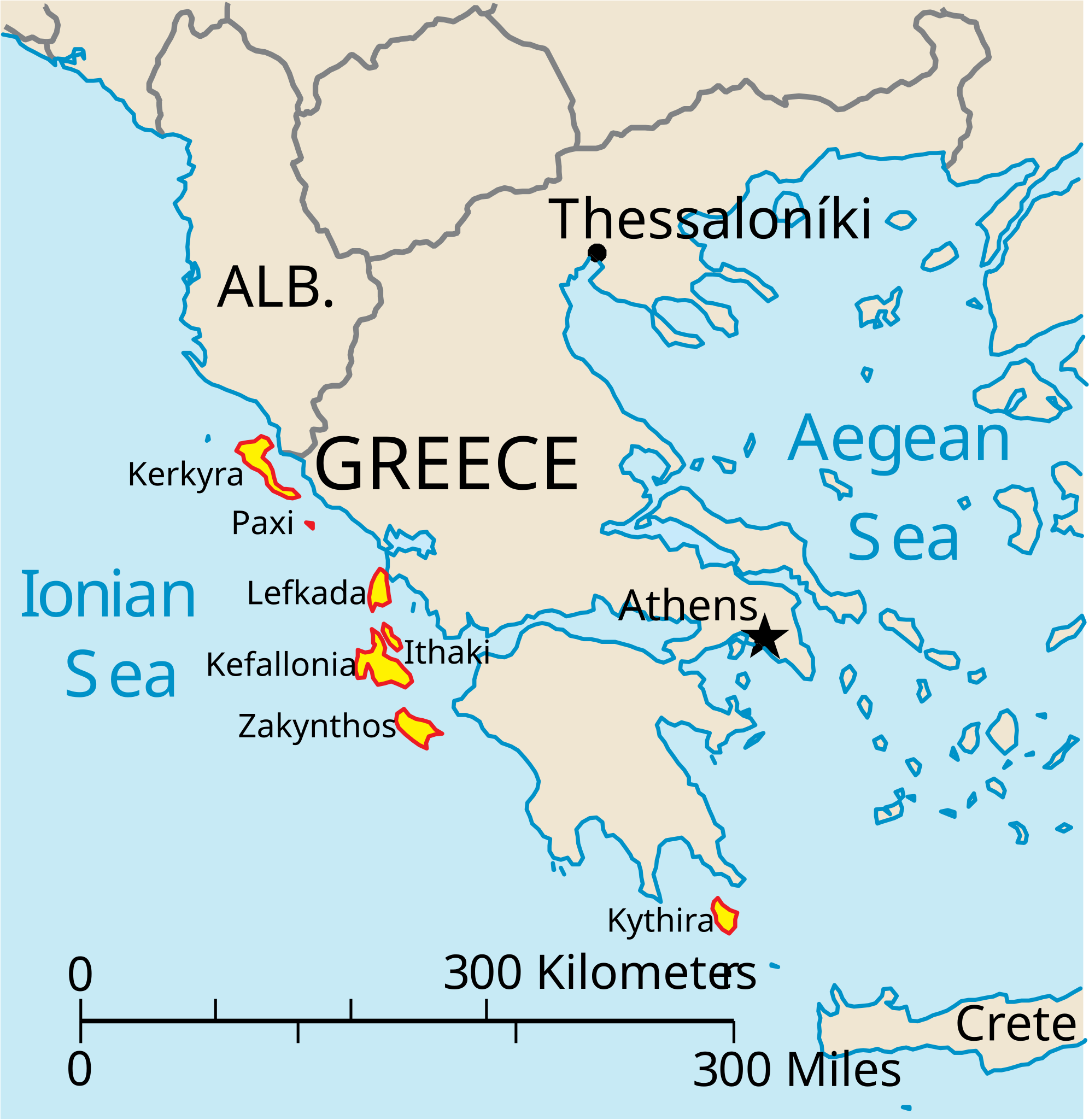
English: Map of the Ionian Islands off Greece. |
| Дата | |
| Източник | Собствена творба, Original vector data taken from the 2006 CIA World Factbook map of Europe. All modifications were made by me, and are free for anyone to use for any purpose. |
| Автор | Electionworld |
| други версии |
Version en français : |
Лицензиране
This image is in the public domain because it contains materials that originally came from the United States Central Intelligence Agency's World Factbook.
|
 |
История на файла
Избирането на дата/час ще покаже как е изглеждал файлът към онзи момент.
| Дата/Час | Миникартинка | Размер | Потребител | Коментар | |
|---|---|---|---|---|---|
| текуща | 14:39, 4 април 2010 | | 532 × 547 (281 КБ) | Kmusser | rm Macedonia label, not important to the map and avoids POV issue |
| 20:17, 20 декември 2006 |  | 532 × 547 (258 КБ) | Electionworld | {{ew|en|IMeowbot}} == Summary == Map of the Ionian Islands off Greece. Original vector data taken from the 2006 CIA World Factbook map of Europe. All modifications were made by me, and are free for anyone to use for any purpose. == Licensing == {{PD-US |
Използване на файла
Следните 2 страници използват следния файл:
Глобално използване на файл
Този файл се използва от следните други уикита:
- Употреба в ar.wikipedia.org
- Употреба в ast.wikipedia.org
- Употреба в be.wikipedia.org
- Употреба в ceb.wikipedia.org
- Употреба в ce.wikipedia.org
- Употреба в cy.wikipedia.org
- Употреба в da.wikipedia.org
- Употреба в de.wikipedia.org
- Употреба в en.wikipedia.org
- Употреба в et.wikipedia.org
- Употреба в fa.wikipedia.org
- Употреба в fi.wikipedia.org
- Употреба в fr.wikipedia.org
- Употреба в he.wikipedia.org
- Употреба в hr.wikipedia.org
- Употреба в hu.wikipedia.org
- Употреба в hyw.wikipedia.org
- Употреба в id.wikipedia.org
- Употреба в it.wikipedia.org
Преглед на глобалната употреба на файла.