
Файл:Israel - Location Map (2012) - ISR - UNOCHA.svg

Оригинален файл (Файл във формат SVG, основен размер: 250 × 250 пиксела, големина на файла: 141 КБ)
| Този файл е от Общомедия и може да се използва от други проекти.
Следва информация за файла, достъпна през оригиналната му описателна страница. |
Резюме
| Описание |
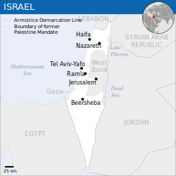
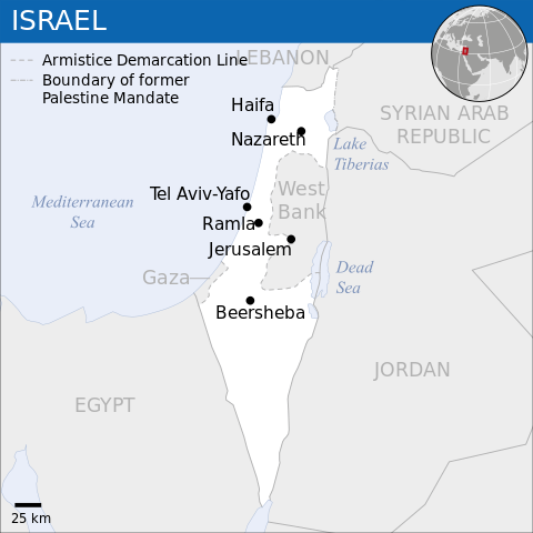
English: Locator map of Israel. العربية: خريطة إسرائيل. |
| Дата | |
| Източник |
English: [1], OCHA, UNCS |
| Автор | |
| други версии |
|
| SVG развитие |
_-_ISR_-_UNOCHA-ar.svg)
_-_ISR_-_UNOCHA-ur.svg)
_-_ISR_-_UNOCHA-zh.svg)
_-_ISR_-_UNOCHA-id.svg)
_-_ISR_-_UNOCHA.svg)
Лицензиране
- Можете свободно:
- да споделяте – да копирате, разпространявате и излъчвате произведението
- да ремиксирате – да адаптирате произведението
- Съгласно следните условия:
- признание на авторството – Трябва да посочите авторството, да добавите връзка към лиценза и да посочите дали са правени промени. Можете да направите това по всякакъв разумен начин, но не и по начин, оставящ впечатлението, че същият/същите подкрепят вас или използването по някакъв начин на творбата от вас.
 This map is part of a collection of 216 free country maps, created by the UN Office for the Coordination of Humanitarian Affairs (OCHA), to be used in print, web or broadcast products.
The ReliefWeb Location Maps released here are maps that highlight a country, its capital, major populated places and the surrounding regions. Attribution Requirements
Using the map without modifications: ensure that the sources and the disclaimer are below the map. Credit as follows: "Credit: OCHA". For use with alteration: remove the OCHA logo and disclaimer following any modification to the map, but keep the data sources as mentioned below the map. Credit the modified map as follows: "Based on OCHA map". You are responsible for the content of your map. We are keen to receive your feedback and hear how you used OCHA's maps. We would be grateful if you would notify us by e-mail and share your work with us. UN Disclaimer
The designations employed and the presentation of material of this map do not imply the expression of any opinion whatsoever on the part of the Secretariat of the United Nations concerning the legal status of any country, territory, city or area or of its authorities or concerning the delimitation of its frontiers or boundaries. |

|
Textual information (e.g. timestamp) once visible in the image itself has been moved into the image metadata and/or image description page. This makes the image easier to reuse and more language-neutral, and makes the text easier to process and search for. Commons discourages placing visible textual information in images. All licenses accepted on Commons permit this type of modification as a derivative work.
If attribution information were removed and the image is not public domain, replace this tag with {{Attribution metadata from licensed image}}.
|
История на файла
Избирането на дата/час ще покаже как е изглеждал файлът към онзи момент.
| Дата/Час | Миникартинка | Размер | Потребител | Коментар | |
|---|---|---|---|---|---|
| текуща | 08:26, 8 октомври 2023 | | 250 × 250 (141 КБ) | Trần Nguyễn Minh Huy | File uploaded using svgtranslate tool (https://svgtranslate.toolforge.org/). Added translation for vi. |
| 06:39, 27 юли 2022 |  | 250 × 250 (140 КБ) | Enkhsaihan2005 | File uploaded using svgtranslate tool (https://svgtranslate.toolforge.org/). Added translation for mn. | |
| 06:38, 27 юли 2022 |  | 250 × 250 (139 КБ) | Enkhsaihan2005 | File uploaded using svgtranslate tool (https://svgtranslate.toolforge.org/). Added translation for mn. | |
| 01:48, 28 март 2022 |  | 250 × 250 (136 КБ) | Nyilvoskt | File uploaded using svgtranslate tool (https://svgtranslate.toolforge.org/). Added translation for id. | |
| 15:21, 17 февруари 2022 |  | 250 × 250 (134 КБ) | Kurmanbek | File uploaded using svgtranslate tool (https://svgtranslate.toolforge.org/). Added translation for tr. | |
| 22:27, 17 февруари 2016 |  | 250 × 250 (130 КБ) | Wereldburger758 | Resized page to drawing. Removal watermark. Validation of image. | |
| 03:21, 19 август 2014 |  | 250 × 250 (185 КБ) | Pharos | == {{int:filedesc}} == {{Information |description={{en|1=Locator map of Chile.}} |date=2013 |source={{en|1=[http://reliefweb.int/map/chile/chile-location-map-2013 Chile Locator Map (ReliefWeb)]}} |author={{en|1=[[w:en:United Nations Offi... |
Използване на файла
Няма страници, използващи файла.
Глобално използване на файл
Този файл се използва от следните други уикита:
- Употреба в ar.wikipedia.org
- Употреба в az.wikipedia.org
- Употреба в ban.wikipedia.org
- Употреба в bcl.wikipedia.org
- Употреба в bh.wikipedia.org
- Употреба в blk.wikipedia.org
- Употреба в bxr.wikipedia.org
- Употреба в dty.wikipedia.org
- Употреба в en.wikipedia.org
- Употреба в es.wikipedia.org
- Употреба в eu.wikipedia.org
- Употреба в fa.wikipedia.org
- Употреба в fr.wikipedia.org
- Употреба в gu.wikipedia.org
- Употреба в hy.wikipedia.org
- Употреба в id.wikipedia.org
- Употреба в incubator.wikimedia.org
- Употреба в ka.wikipedia.org
- Употреба в lo.wikipedia.org
- Употреба в ml.wikipedia.org
- Употреба в mn.wikipedia.org
- Употреба в mzn.wikipedia.org
- Употреба в ne.wikipedia.org
- Употреба в nso.wikipedia.org
- Употреба в pa.wikipedia.org
- Употреба в pnb.wikipedia.org
- Употреба в ps.wikipedia.org
- Употреба в ro.wikipedia.org
- Употреба в ru.wikipedia.org
- Употреба в sco.wikipedia.org
- Употреба в sd.wikipedia.org
- Употреба в si.wikipedia.org
- Употреба в sl.wikipedia.org
- Употреба в sq.wikipedia.org
- Употреба в su.wikipedia.org
- Употреба в tcy.wikipedia.org
- Употреба в te.wikipedia.org
- Употреба в th.wikipedia.org
- Употреба в to.wikipedia.org
Преглед на глобалната употреба на файла.
_-_ISR_-_UNOCHA.svg)
_-_ISR_-_UNOCHA.svg)