
Файл:Maine state capitol.jpg

Оригинален файл (1500 × 2000 пиксела, големина на файла: 1,26 МБ, MIME-тип: image/jpeg)
| Този файл е от Общомедия и може да се използва от други проекти.
Следва информация за файла, достъпна през оригиналната му описателна страница. |
|
This is an image of a place or building that is listed on the National Register of Historic Places in the United States of America. Its reference number is 73000266. |
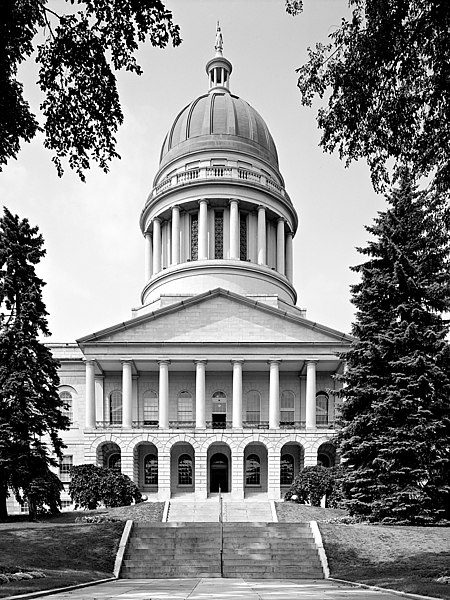
Maine State House, State & Capitol Streets, Augusta, Kennebec County, ME
Main (South) elevation
August 1965
- Photographer
- Jack E. Boucher
- Original file
- 17MB TIFF file, corrected, cropped, denoised, converted to JPEG

|
This file comes from the Historic American Buildings Survey (HABS), Historic American Engineering Record (HAER) or Historic American Landscapes Survey (HALS). These are programs of the National Park Service established for the purpose of documenting historic places. Records consist of measured drawings, archival photographs, and written reports.
|
| This image or media file contains material based on a work of a National Park Service employee, created as part of that person's official duties. As a work of the U.S. federal government, such work is in the public domain in the United States. See the NPS website and NPS copyright policy for more information. |
| Object location | | View this and other nearby images on: OpenStreetMap |
|---|
История на файла
Избирането на дата/час ще покаже как е изглеждал файлът към онзи момент.
| Дата/Час | Миникартинка | Размер | Потребител | Коментар | |
|---|---|---|---|---|---|
| текуща | 07:13, 4 февруари 2005 | | 1500 × 2000 (1,26 МБ) | MarkSweep | Maine state capitol {{HABS}} |
Използване на файла
Следните 2 страници използват следния файл:
Глобално използване на файл
Този файл се използва от следните други уикита:
- Употреба в da.wikipedia.org
- Употреба в de.wikipedia.org
- Употреба в el.wikipedia.org
- Употреба в en.wikipedia.org
- Употреба в en.wikivoyage.org
- Употреба в es.wikipedia.org
- Употреба в fa.wikipedia.org
- Употреба в fi.wikipedia.org
- Употреба в fo.wikipedia.org
- Употреба в fr.wikipedia.org
- Употреба в gl.wikipedia.org
- Употреба в he.wikipedia.org
- Употреба в hy.wikipedia.org
- Употреба в it.wikipedia.org
- Употреба в ja.wikipedia.org
- Употреба в kk.wikipedia.org
- Употреба в ko.wikipedia.org
- Употреба в lmo.wikipedia.org
- Употреба в mi.wikipedia.org
- Употреба в nl.wikipedia.org
- Употреба в pl.wikipedia.org
- Употреба в pnb.wikipedia.org
- Употреба в pt.wikipedia.org
- Употреба в ro.wikipedia.org
- Употреба в ru.wikipedia.org
- Употреба в www.wikidata.org
- Употреба в zh.wikipedia.org