
Файл:Map of the location of political prison camps (kwanliso) and ordinary prison camps (kyohwaso) in North Korea (United Nations, 2014).pdf

Оригинален файл (1239 × 1754 пиксела, големина на файла: 681 КБ, MIME-тип: application/pdf)
| Този файл е от Общомедия и може да се използва от други проекти.
Следва информация за файла, достъпна през оригиналната му описателна страница. |
Резюме
| Описание |
English: Map of the location of political prison camps (kwanliso) and ordinary prison camps (kyohwaso) in the Democratic People's Republic of Korea (North Korea).
Map issued in 2014 by the Commission of Inquiry on Human Rights in the Democratic People's Republic of Korea, under the United Nations Human Rights Council. |
| Дата | |
| Източник | United Nations - Human Rights Council - Commission of Inquiry on Human Rights in the Democratic People's Republic of Korea (http://www.ohchr.org/EN/HRBodies/HRC/CoIDPRK/Pages/ReportoftheCommissionofInquiryDPRK.aspx; http://www.ohchr.org/Documents/HRBodies/HRCouncil/CoIDPRK/Report/map/coi-dprk-map-large.pdf) |
| Автор | United Nations - Human Rights Council - Commission of Inquiry on Human Rights in the Democratic People's Republic of Korea: Michael Donald Kirby (Chair),Sonja Biserko, Marzuki Darusman (Special Rapporteur). |
Лицензиране
| This image is a map derived from a United Nations map.
Unless stated otherwise, UN maps are to be considered in the public domain. This applies worldwide. UN maps are, in principle, open source material and you can use them in your work or for making your own map. UN requests however that you delete the UN name, logo and reference number upon any modification to the map. Content of your map will be your responsibility. You can state in your publication, if you wish, something like: based on UN map … (map name, map number, revision number and date). See: Geospatial Information Section. And: Geospatial, location data for a better world. |
 |
История на файла
Избирането на дата/час ще покаже как е изглеждал файлът към онзи момент.
| Дата/Час | Миникартинка | Размер | Потребител | Коментар | |
|---|---|---|---|---|---|
| текуща | 03:11, 10 юни 2018 | 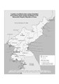 | 1239 × 1754 (681 КБ) | Al83tito | User created page with UploadWizard |
Използване на файла
Следната страница използва следния файл:
Глобално използване на файл
Този файл се използва от следните други уикита:
- Употреба в en.wikipedia.org
- Употреба в fr.wikipedia.org
- Употреба в it.wikipedia.org
- Употреба в ja.wikipedia.org
- Употреба в pt.wikipedia.org
- Употреба в sl.wikipedia.org
- Употреба в tl.wikipedia.org
- Употреба в vi.wikipedia.org
- Употреба в www.wikidata.org
- Употреба в zh.wikipedia.org