
Файл:MarsTopoMap-PIA02031 modest.jpg

Размер на този преглед: 674 × 600 пиксела. Други разделителни способности: 270 × 240 пиксела | 540 × 480 пиксела | 864 × 768 пиксела | 1151 × 1024 пиксела | 2497 × 2221 пиксела.
Оригинален файл (2497 × 2221 пиксела, големина на файла: 1,09 МБ, MIME-тип: image/jpeg)
| Този файл е от Общомедия и може да се използва от други проекти.
Следва информация за файла, достъпна през оригиналната му описателна страница. |
Резюме


| Описание |
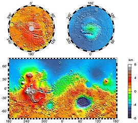
English: Maps of Mars' global topography. The projections are Mercator to 70° latitude and stereographic at the poles with the south pole at left and north pole at right. Note the elevation difference between the northern and southern hemispheres. The Tharsis volcano-tectonic province is centered near the equator in the longitude range 220° E to 300° E and contains the vast east-west trending Valles Marineris canyon system and several major volcanic shields including Olympus Mons (18° N, 225° E), Alba Patera (42° N, 252° E), Ascraeus Mons (12° N, 248° E), Pavonis Mons (0°, 247° E), and Arsia Mons (9° S, 239° E). Regions and structures discussed in the text include Solis Planum (25° S, 270° E), Lunae Planum (10° N, 290° E), and Claritas Fossae (30° S, 255° E). Major impact basins include Hellas (45° S, 70° E), Argyre (50° S, 320° E), Isidis (12° N, 88° E), and Utopia (45° N, 110° E). This analysis uses an areocentric coordinate convention with east longitude positive.
Русский: Топографическая карта Марса. |
| Дата | |
| Източник |
http://photojournal.jpl.nasa.gov/jpeg/PIA02031.jpg
|
| Автор | NASA/JPL-Caltech/GSFC |
| Права (Повторно използване на файла) |
PD-USGOV-NASA |
Тази картинка е каталогизирина от Лабораторията за реактивно движение към НАСА с идентификационен номер (Photo ID): PIA02031. Този етикет не посочва статуса около авторското право към прикачената творба. Изисква се нормален етикет за авторско право. Вижте Общомедия:Лицензиране за повече информация. Други езици:
|
Лицензиране
| This file is in the public domain in the United States because it was solely created by NASA. NASA copyright policy states that "NASA material is not protected by copyright unless noted". (See Template:PD-USGov, NASA copyright policy page or JPL Image Use Policy.) | ||
 |
Warnings:
|
Дневник на оригиналното качване
The original description page was here. All following user names refer to en.wikipedia.
- 2004-05-06 16:52 Wwoods 612×545×8 (88223 bytes) Topographic Map of Mars; http://photojournal.jpl.nasa.gov/catalog/PIA02031 ; {{msg:PD}}
| Annotations | This image is annotated: View the annotations at Commons |


История на файла
Избирането на дата/час ще покаже как е изглеждал файлът към онзи момент.
| Дата/Час | Миникартинка | Размер | Потребител | Коментар | |
|---|---|---|---|---|---|
| текуща | 00:43, 22 март 2005 | | 2497 × 2221 (1,09 МБ) | Wikibob~commonswiki | high res jpg from http://photojournal.jpl.nasa.gov/jpeg/PIA02031.jpg PD |
| 16:40, 30 декември 2004 |  | 612 × 545 (86 КБ) | Kristaga | NASA-photo, all NASA images are free to use. |
Използване на файла
Следната страница използва следния файл:
Глобално използване на файл
Този файл се използва от следните други уикита:
- Употреба в als.wikipedia.org
- Употреба в ar.wikipedia.org
- Употреба в be.wikipedia.org
- Употреба в bo.wikipedia.org
- Употреба в ca.wikipedia.org
- Употреба в ca.wikibooks.org
- Употреба в cv.wikipedia.org
- Употреба в de.wikipedia.org
- Употреба в el.wikipedia.org
- Употреба в en.wikipedia.org
- User:Mcdavis941/mars
- Wikipedia:Reference desk/Science/Archive
- User:Scholar743/subpage3
- Mars ocean theory
- Phaethontis quadrangle
- Water on Mars
- Ptolemaeus (Martian crater)
- Tader Valles
- Gorgonum Chaos
- Wikipedia:Reference desk/Archives/Science/2010 September 26
- User talk:Wikileadspresident
- List of largest craters in the Solar System
- User:Jimmarsmars/sandbox
- Lakes on Mars
- Употреба в en.wikiversity.org
- Употреба в es.wikipedia.org
- Употреба в eu.wikipedia.org
- Употреба в fa.wikipedia.org
- Употреба в fi.wikipedia.org
- Употреба в fr.wikipedia.org
- Употреба в gl.wikipedia.org
- Употреба в he.wikipedia.org
- Употреба в hi.wikipedia.org
- Употреба в hr.wikipedia.org
- Употреба в hu.wikipedia.org
- Употреба в hy.wikipedia.org
Преглед на глобалната употреба на файла.