
Файл:Paramushir, Atlasov, Shumshu - Landsat 7.jpg

Размер на този преглед: 542 × 599 пиксела. Други разделителни способности: 217 × 240 пиксела | 434 × 480 пиксела | 695 × 768 пиксела | 926 × 1024 пиксела | 1852 × 2048 пиксела | 3600 × 3980 пиксела.
Оригинален файл (3600 × 3980 пиксела, големина на файла: 3,16 МБ, MIME-тип: image/jpeg)
| Този файл е от Общомедия и може да се използва от други проекти.
Следва информация за файла, достъпна през оригиналната му описателна страница. |
Резюме
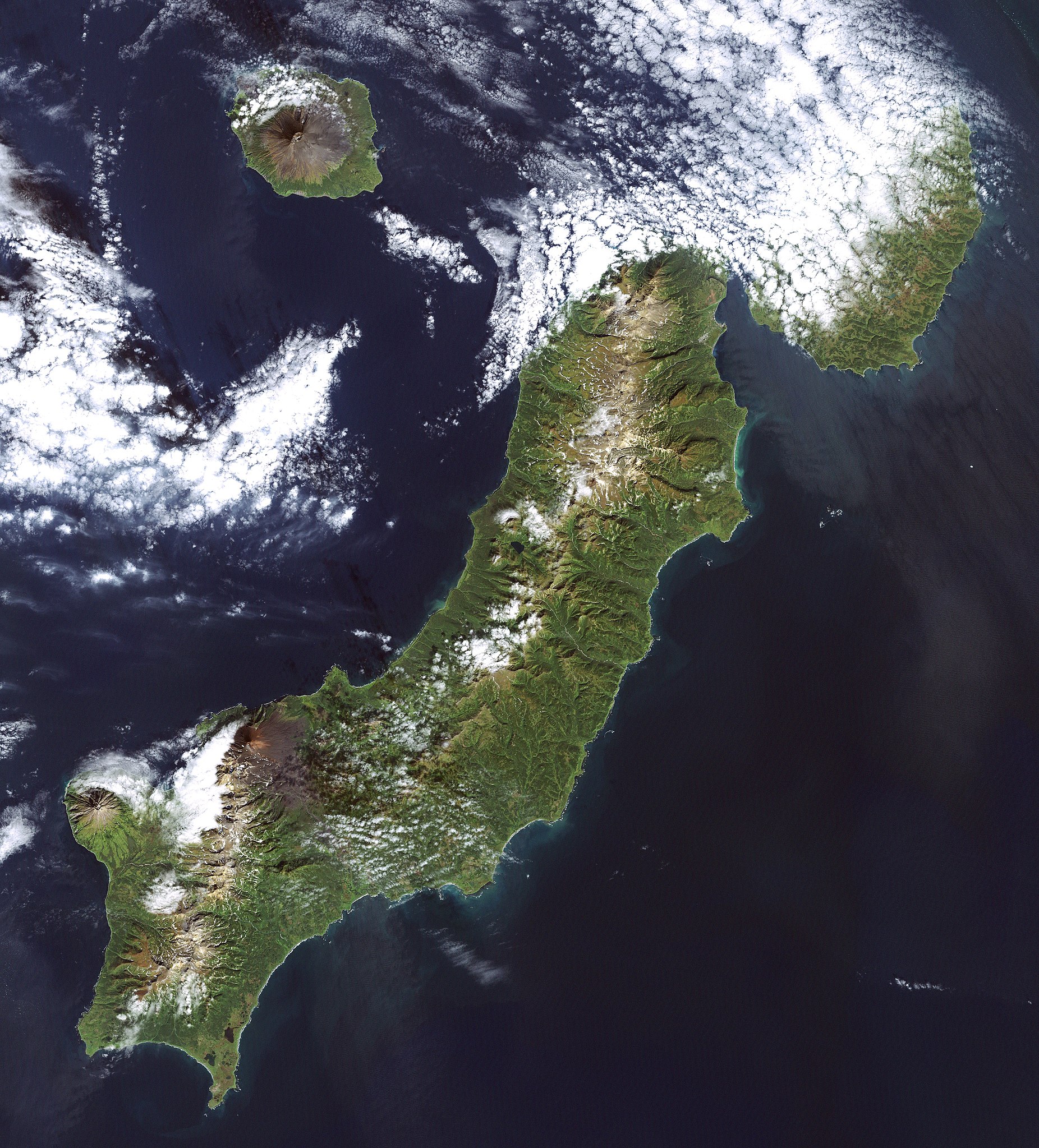
Čeština: Paramušir ( rusky Остров Парамушир; japonsky: 幌筵島, Paramuširu-tó nebo Horomuširo-tó; v ainštině znamená široká země (poro mošir)) je největším ostrovem severní části Kurilského souostroví a zároveň druhým největším ostrovem celého souostroví po ostrově Iturup.
English: Paramushir () or Paramushiro is the second largest of the Kuril Islands, lying near the north of the archipelago. It is governed by Russia. It is home to several volcanoes, including Fuss Peak at 1,772m and Chikurachki at 1,816m. Severo-Kurilsk, the northernmost settlement of the islands, lies on Paramushir.
日本語: 幌筵島(ほろむしろとう・パラムシルとうとも読む)は、 千島列島の北東部にある島。、ロシア連邦の実効支配下にあるが、日本政府は国際法上は所属未定地であると主張している。ロシア名パラムシル島()
Русский: Парамушир ( парамусиру-сима, от айнского широкий остров) — один из островов Северной группы Большой гряды Курильских островов. Площадь 2479 км², это второй по площади после Итурупа остров архипелега. В длину — около 120 км, ширина до 30 км.
(This summary was created using Commons SumItUp)
| Описание | Landsat 7 image of the Kuril Islands of Paramushir, Atlasov, and Shumshu, 28.5 meter resolution. (Shumshu is mostly cloud-covered.) Based on Global Orthorectified Landsat dataset (ETM+); WRS_PATH 100, WRS_ROW 025. Generated using "true-color" combination of bands 3, 2, & 1 as R, G, B respectively. Color curves enhanced in the Gimp. |
| Дата | Data acquisition: 2000-09-20. Orthorectified version produced: 2002-12-04. Image created: 2007-02-04. |
| Източник | Data from USGS GloVis server http://glovis.usgs.gov/. Landsat Orthorectified data generated through NASA's Commercial Remote Sensing Program. |
| Автор | Data: NASA. Image: Dave Pape |
| Права (Повторно използване на файла) |
Original data PD-NASA; any copyright that exists from my creation of this image is dedicated to the public domain (PD-SELF) |
| Camera location | | View this and other nearby images on: OpenStreetMap |
|---|
Лицензиране
| This file is in the public domain in the United States because it was solely created by NASA. NASA copyright policy states that "NASA material is not protected by copyright unless noted". (See Template:PD-USGov, NASA copyright policy page or JPL Image Use Policy.) | ||
 |
Warnings:
|
This work is based on a work in the public domain. It has been digitally enhanced and/or modified. This derivative work has been (or is hereby) released into the public domain by its author, Davepape. This applies worldwide.
In some countries this may not be legally possible; if so: |
История на файла
Избирането на дата/час ще покаже как е изглеждал файлът към онзи момент.
| Дата/Час | Миникартинка | Размер | Потребител | Коментар | |
|---|---|---|---|---|---|
| текуща | 19:56, 5 февруари 2007 | | 3600 × 3980 (3,16 МБ) | Davepape | {{cs|'''Paramušir''' ( rusky ''Остров Парамушир''; japonsky: 幌筵島, ''Paramuširu-tó'' nebo ''Horomuširo-tó''; v ainštině znamená ''široká země'' (''poro mošir'')) je nej |
Използване на файла
Следната страница използва следния файл:
Глобално използване на файл
Този файл се използва от следните други уикита:
- Употреба в ace.wikipedia.org
- Употреба в af.wikipedia.org
- Употреба в arz.wikipedia.org
- Употреба в ca.wikipedia.org
- Употреба в ceb.wikipedia.org
- Употреба в cs.wikipedia.org
- Употреба в el.wikipedia.org
- Употреба в en.wikipedia.org
- Употреба в et.wikipedia.org
- Употреба в eu.wikipedia.org
- Употреба в fr.wikipedia.org
- Употреба в gl.wikipedia.org
- Употреба в id.wikipedia.org
- Употреба в ja.wikipedia.org
- Употреба в ko.wikipedia.org
- Употреба в ky.wikipedia.org
- Употреба в nn.wikipedia.org
- Употреба в no.wikipedia.org
- Употреба в pl.wikipedia.org
- Употреба в pt.wikipedia.org
- Употреба в ru.wikipedia.org
- Употреба в sk.wikipedia.org
- Употреба в tr.wikipedia.org
- Употреба в uk.wikipedia.org
- Употреба в vi.wikipedia.org
- Употреба в www.wikidata.org
- Употреба в zh.wikipedia.org