
Файл:Passchendaele aerial view.jpg
Оригинален файл (500 × 674 пиксела, големина на файла: 317 КБ, MIME-тип: image/jpeg)
| Този файл е от Общомедия и може да се използва от други проекти.
Следва информация за файла, достъпна през оригиналната му описателна страница. |
|

|
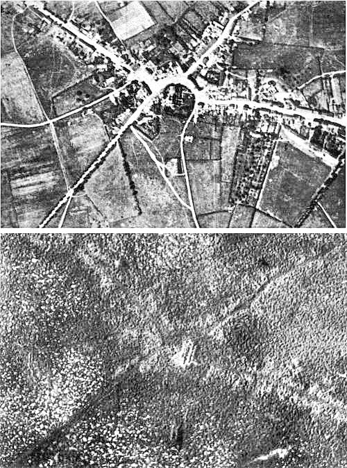
Това изображение е оценено в съответствие с критериите за ценни изображения и е признато като най-ценната снимка в Общомедия в категорията the Battle of Passchendaele. Може да прегледате номинацията в Commons:Valued image candidates/Passchendaele aerial view.jpg. |
| Описание |
English: Aerial view of the village of Passchendaele (north is to the right of the photo) before and after the Third Battle of Ypres, 1917.
Français : Vue aerienne du village de Passendale, avant et après la troisième bataille d'Ypres, en 1917. Le nord est à droite sur les photos. |
|||
| Дата | ||||
| Източник |
|
|||
| Автор | Photographer not identified. "Official photograph". | |||
| Права (Повторно използване на файла) |
|
|||
| други версии |
|


| Camera location | | View this and other nearby images on: OpenStreetMap |
|---|
История на файла
Избирането на дата/час ще покаже как е изглеждал файлът към онзи момент.
| Дата/Час | Миникартинка | Размер | Потребител | Коментар | |
|---|---|---|---|---|---|
| текуща | 17:33, 22 декември 2011 | | 500 × 674 (317 КБ) | Soerfm | Sharpness |
| 11:23, 25 април 2005 |  | 500 × 674 (290 КБ) | Gsl~commonswiki | Second version: Lightened and set levels. Sharpened slightly (by w:User:Ian Dunster) | |
| 11:21, 25 април 2005 |  | 500 × 674 (81 КБ) | Gsl~commonswiki | Original version from en.wikipedia.org |
Използване на файла
Следната страница използва следния файл:
Глобално използване на файл
Този файл се използва от следните други уикита:
- Употреба в ar.wikipedia.org
- Употреба в ast.wikipedia.org
- Употреба в az.wikipedia.org
- Употреба в bn.wikipedia.org
- Употреба в br.wikipedia.org
- Употреба в ca.wikipedia.org
- Употреба в cs.wikipedia.org
- Употреба в da.wikipedia.org
- Употреба в de.wikipedia.org
- Употреба в el.wikipedia.org
- Употреба в en.wikipedia.org
- Battle of Passchendaele
- Wikipedia:Featured picture candidates/October-2004
- Wikipedia:Picture of the day/November 2004
- Wikipedia:Picture of the day/November 7, 2004
- Wikipedia:POTD/November 7, 2004
- Alexander Edwards
- Wikipedia:Picture of the day/February 2005
- Wikipedia:POTD/February 21, 2005
- Wikipedia:Picture of the day/February 21, 2005
- Wikipedia:Picture of the day/December 2005
- Wikipedia:Picture of the day/December 21, 2005
- Wikipedia:POTD/December 21, 2005
- User:Cyde/Featured pictures
- Passendale
- Portal:United Kingdom/Featured picture/12
- Portal:United Kingdom/Featured picture
- Second Battle of Passchendaele
- Wikipedia:Featured picture candidates/delist/2008
- Wikipedia:Featured picture candidates/delist/Village of Passchendaele
- User talk:Durova/Archive 61
- Wikipedia:Featured picture candidates/delist/2009
- Wikipedia:Featured picture candidates/delist/File:Passchendaele aerial view.jpg
- User:Durova/FPC survey
- Wikipedia talk:Valued picture candidates/Archive 3
- Wikipedia:Featured picture candidates/delist/2015
- Wikipedia:Featured picture candidates/delist/Passchendaele
- Night action of 1/2 December 1917
- Употреба в es.wikipedia.org
- Употреба в fi.wikipedia.org
- Употреба в fr.wikipedia.org
- Употреба в fy.wikipedia.org
- Употреба в gl.wikipedia.org
Преглед на глобалната употреба на файла.