
Файл:Pinal County Arizona Incorporated and Unincorporated areas Kearny highlighted.svg

Размер на този PNG предварителен преглед на изходния SVG файл: 800 × 600 пиксела. Други разделителни способности: 320 × 240 пиксела | 640 × 480 пиксела | 1024 × 768 пиксела | 1280 × 960 пиксела | 2560 × 1920 пиксела.
Оригинален файл (Файл във формат SVG, основен размер: 800 × 600 пиксела, големина на файла: 146 КБ)
| Този файл е от Общомедия и може да се използва от други проекти.
Следва информация за файла, достъпна през оригиналната му описателна страница. |
Резюме
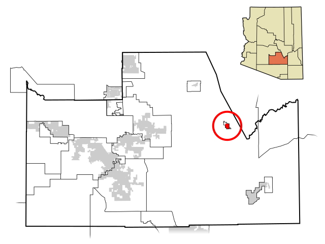
| Описание | This map shows the incorporated areas and unincorporated areas in Pinal County, Arizona. Kearny is highlighted in red. Other incorporated cities are shown in gray, planning area borders for these cities and Indian reservation borders are shown as solid black lines. Map data is based on the following files as noted, all of which are .pdf files: *Pinal County 2008 Comprehensive Plan Amendments (.pdf) - For determining incorporated and Indian reservation boundaries. *CAAG Pinal Planning Commissioners Presentation (.pdf) - For determining planning area boundaries in Pinal County. *CAAG Population Estimates for Pinal County Places (.pdf) - For determining boundaries of unincorporated areas in Pinal County. Additional data for cities shown are based on individual files from each city's Website. (Please view the category page for links to these files.) I created this map in Inkscape. Please Note: This file replaces Image:Pinal County Incorporated areas Kearny highlighted.svg, which is now obsolete! |
| Дата | |
| Източник | My own work, based on public domain information |
| Автор | Ixnayonthetimmay |
| Права (Повторно използване на файла) |
Public Domain |
| други версии | See Category:Maps of Pinal County for other versions of this image. |
Лицензиране
| Аз, носителят на авторските права над тази творба, я публикувам като обществено достояние. Това разрешение е в сила за целия свят. В някои държави това може да не е възможно от законодателна гледна точка; затова: Давам на всекиго правото да използва тази творба за всякакви цели, без никакви условия, освен ако такива условия съществуват по закон. |
История на файла
Избирането на дата/час ще покаже как е изглеждал файлът към онзи момент.
| Дата/Час | Миникартинка | Размер | Потребител | Коментар | |
|---|---|---|---|---|---|
| текуща | 05:32, 8 юли 2009 | | 800 × 600 (146 КБ) | Ixnayonthetimmay | == Summary == {{Information |Description=This map shows the incorporated areas and unincorporated areas in Pinal County, Arizona. [[:en:Gold Camp, Arizona|Gold |
| 17:31, 19 април 2008 |  | 800 × 600 (156 КБ) | Ixnayonthetimmay | == Summary == {{Information |Description=This map shows the incorporated areas and unincorporated areas in Pinal County, Arizona. Kearny |
Използване на файла
Няма страници, използващи файла.
Глобално използване на файл
Този файл се използва от следните други уикита:
- Употреба в ar.wikipedia.org
- Употреба в ca.wikipedia.org
- Употреба в ceb.wikipedia.org
- Употреба в cy.wikipedia.org
- Употреба в eu.wikipedia.org
- Употреба в fa.wikipedia.org
- Употреба в fr.wikipedia.org
- Употреба в ht.wikipedia.org
- Употреба в it.wikipedia.org
- Употреба в pt.wikipedia.org
- Употреба в sr.wikipedia.org
- Употреба в tt.wikipedia.org
- Употреба в www.wikidata.org
- Употреба в zh-min-nan.wikipedia.org