
Файл:Sarychev Volcano edit.jpg

Оригинален файл (2734 × 2208 пиксела, големина на файла: 551 КБ, MIME-тип: image/jpeg)
| Този файл е от Общомедия и може да се използва от други проекти.
Следва информация за файла, достъпна през оригиналната му описателна страница. |
Резюме
| Описание |
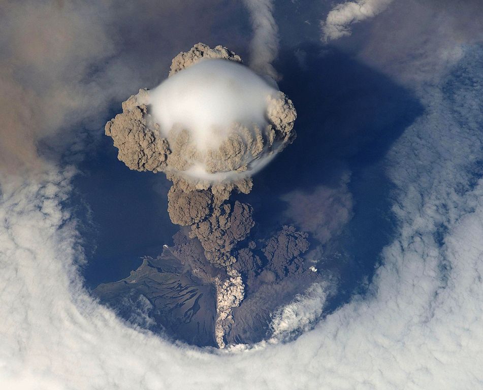
Čeština: Erupce sopky Saryčeva na ostrově Matua v Kurilských ostrovech. Fotografováno 12. června 2009 z Mezinárodní vesmírné stanice. Deutsch: Eruption des Vulkans Sarytschew am 12. Juni 2009. English: A picture of Russia's Sarychev Volcano, on Matua Island in the Kuril Islands, erupting on 12 June 2009, as seen from the International Space Station (ISS). The ISS orbits the Earth at a height of between 347 and 360 km. Original description by NASA: "Prior to June 12, the last explosive eruption had occurred in 1989 with eruptions in 1986, 1976, 1954 and 1946 also producing lava flows. Commercial airline flights were diverted from the region to minimize the danger of engine failures from ash intake. This detailed photograph is exciting to volcanologists because it captures several phenomena that occur during the earliest stages of an explosive volcanic eruption. "The main column is one of a series of plumes that rose above Matua Island (48.1 degrees north latitude and 153.2 degrees east longitude) on June 12. The plume appears to be a combination of brown ash and white steam. The vigorously rising plume gives the steam a bubble-like appearance; the surrounding atmosphere has been shoved up by the shock wave of the eruption. The smooth white cloud on top may be water condensation that resulted from rapid rising and cooling of the air mass above the ash column, and is probably a transient feature (the eruption plume is starting to punch through). The structure also indicates that little to no shearing winds were present at the time to disrupt the plume. By contrast, a cloud of denser, gray ash -- most probably a pyroclastic flow -- appears to be hugging the ground, descending from the volcano summit. The rising eruption plume casts a shadow to the northwest of the island (bottom center). Brown ash at a lower altitude of the atmosphere spreads out above the ground at upper right. Low-level stratus clouds approach Matua Island from the east, wrapping around the lower slopes of the volcano. Only about 1.5 kilometers of the coastline of Matua Island (upper center) can be seen beneath the clouds and ash."Français : Le volcan Sarychev, sur l'île Matua, en éruption. Photo prise le 12 juin 2009. 中文: 2009年6月12日萨雷切夫火山喷发情景。该火山位于千岛群岛中的马图阿岛。 |
| Дата | (UTC) |
| Източник | |
| Автор |
|
| This is a retouched picture, which means that it has been digitally altered from its original version. Modifications: Rotated and cropped; empty corners filled in using smart replace filter; all darkened. The original can be viewed here: Sarychev Volcano.jpg:
|
|
Лицензиране
| This file is in the public domain in the United States because it was solely created by NASA. NASA copyright policy states that "NASA material is not protected by copyright unless noted". (See Template:PD-USGov, NASA copyright policy page or JPL Image Use Policy.) | ||
 |
Warnings:
|
And in case the retouching would attract a copyright:
| Аз, носителят на авторските права над тази творба, я публикувам като обществено достояние. Това разрешение е в сила за целия свят. В някои държави това може да не е възможно от законодателна гледна точка; затова: Давам на всекиго правото да използва тази творба за всякакви цели, без никакви условия, освен ако такива условия съществуват по закон. |
Дневник на оригиналното качване
This image is a derivative work of the following images:
- File:Sarychev_Volcano.jpg licensed with PD-USGov-NASA
- 2009-06-26T18:01:12Z TonyBallioni 4288x2840 (627136 Bytes) {{Information |Description={{en|1=A picture of Russia's Sarychev Volcano, located in the Kuril Islands, erupting, ass seen from the International Space Station}} |Source=http://www.nasa.gov/multimedia/imagegallery/image_featu
Uploaded with derivativeFX
История на файла
Избирането на дата/час ще покаже как е изглеждал файлът към онзи момент.
| Дата/Час | Миникартинка | Размер | Потребител | Коментар | |
|---|---|---|---|---|---|
| текуща | 13:54, 2 ноември 2010 | | 2734 × 2208 (551 КБ) | Avenue | Darken. |
| 13:53, 2 ноември 2010 |  | 2734 × 2208 (510 КБ) | Avenue | Fill in blank areas in upper right and lower left corners using GIMP's "Smart remove selection ..." filter. | |
| 13:46, 2 ноември 2010 |  | 2734 × 2208 (725 КБ) | Avenue | {{Information |Description={{en|1=A picture of Russia's Sarychev Volcano, located in the Kuril Islands, erupting, as seen from the International Space Station}} |Source=*File:Sarychev_Volcano.jpg |Date=2010-11-02 13:43 (UTC) |Author=*[[:File:Saryche |
Използване на файла
Следната страница използва следния файл:
Глобално използване на файл
Този файл се използва от следните други уикита:
- Употреба в cs.wikipedia.org
- Употреба в en.wikipedia.org
- Portal:Geography
- Portal:Geography/Featured picture
- Explosive eruption
- Portal:Earth sciences
- Matua (island)
- Portal:Geology
- Talk:Matua (island)
- User:Ceranthor/FPC
- Wikipedia:Featured pictures/Sciences/Geology
- Wikipedia:WikiProject Volcanoes/Content
- Wikipedia:Featured pictures thumbs/26
- Wikipedia:Featured picture candidates/Sarychev Peak
- Wikipedia:Featured picture candidates/December-2010
- Wikipedia:WikiProject Russia/History of Russia task force
- Wikipedia:WikiProject Russia/Physical geography of Russia task force
- User talk:Ceranthor/Archive 19
- Wikipedia:WikiProject Geology/Recognized content
- Wikipedia:Picture of the day/July 2012
- Template:POTD/2012-07-15
- Wikipedia:Main Page history/2012 July 15
- Wikipedia:WikiProject Russia/Recognized content
- Portal:Geography/Featured picture/10
- Wikipedia:WikiProject Geology/Automated list of recognized content
- Употреба в es.wikipedia.org
- Употреба в fa.wikipedia.org
- Употреба в fi.wikipedia.org
- Употреба в gn.wikipedia.org
- Употреба в he.wikivoyage.org
- Употреба в id.wikipedia.org
- Употреба в kk.wikipedia.org
- Употреба в mk.wikipedia.org
- Употреба в pa.wikipedia.org
- Употреба в sv.wikipedia.org
- Употреба в ur.wikipedia.org
- Употреба в vi.wikipedia.org
- Употреба в www.wikidata.org
- Употреба в zh.wikipedia.org