
Файл:SeptinsularRepublic1801.jpg
SeptinsularRepublic1801.jpg (416 × 424 пиксела, големина на файла: 265 КБ, MIME-тип: image/jpeg)
| Този файл е от Общомедия и може да се използва от други проекти.
Следва информация за файла, достъпна през оригиналната му описателна страница. |

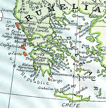
Septinsular Republic (yellow) in 1801, on the 19th century map of Ottoman Empire (green)
|
Това произведение е обществено достояние в държавите, в които срокът на авторското право е 70 години или по-малко след смъртта на автора.
| |
| This file has been identified as being free of known restrictions under copyright law, including all related and neighboring rights. | |
История на файла
Избирането на дата/час ще покаже как е изглеждал файлът към онзи момент.
| Дата/Час | Миникартинка | Размер | Потребител | Коментар | |
|---|---|---|---|---|---|
| текуща | 17:48, 2 март 2010 | | 416 × 424 (265 КБ) | Spiridon Ion Cepleanu | |
| 09:06, 11 март 2006 |  | 416 × 424 (103 КБ) | Julo | thumb Septinsular Republic (yellow) in 1801, on the 19th century map of Ottoman Empire (green) {{PD-old}} category:19th century mapsCategory:Historical maps of the BalkansCategory:Historical maps of Greece |
Използване на файла
Следната страница използва следния файл:
Глобално използване на файл
Този файл се използва от следните други уикита:
- Употреба в ar.wikipedia.org
- Употреба в ast.wikipedia.org
- Употреба в br.wikipedia.org
- Употреба в cs.wikipedia.org
- Употреба в de.wikipedia.org
- Употреба в el.wikipedia.org
- Употреба в en.wikipedia.org
- Употреба в es.wikipedia.org
- Употреба в et.wikipedia.org
- Употреба в fa.wikipedia.org
- Употреба в fi.wikipedia.org
- Употреба в fr.wikipedia.org
- République des Sept-Îles
- Mer-Égée
- Départements français de Grèce
- Évolution territoriale de la France contemporaine
- Wikipédia:Atelier graphique/Cartes/Archives/décembre 2012
- Traité de Constantinople (1800)
- Wikipédia:Atelier graphique/Cartes/Archives/mars 2016
- Utilisateur:Exp JC/Brouillon
- Discussion:Mer-Égée/LSV 21712
- Употреба в gl.wikipedia.org
- Употреба в he.wikipedia.org
- Употреба в id.wikipedia.org
- Употреба в it.wikipedia.org
- Употреба в la.wikipedia.org
- Употреба в ms.wikipedia.org
- Употреба в nl.wikipedia.org
- Употреба в no.wikipedia.org
- Употреба в pl.wikipedia.org
Преглед на глобалната употреба на файла.