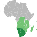
Файл:Southern African Development Community.svg

Съдържанието на страницата не се поддържа на други езици.
от Уикипедия, свободната енциклопедия

Оригинален файл(Файл във формат SVG, основен размер: 1000 × 1000 пиксела, големина на файла: 184 КБ)

Емблемата на Общомедия Този файл е от Общомедия и може да се използва от други проекти.

Следва информация за файла, достъпна през оригиналната му описателна страница.

Резюме

Описание Map of Africa showing the member nations of the Southern African Development Community (SADC). Nations that are members of SADC and the Southern African Customs Union (SACU) are coloured dark green, while those that are members of SADC only are coloured light green.
Дата (UTC)
Източник
Автор

Лицензиране

Public domain Аз, носителят на авторските права над тази творба, я публикувам като обществено достояние. Това разрешение е в сила за целия свят.
В някои държави това може да не е възможно от законодателна гледна точка; затова:
Давам на всекиго правото да използва тази творба за всякакви цели, без никакви условия, освен ако такива условия съществуват по закон.

Дневник на оригиналното качване

This image is a derivative work of the following images:

  • File:BlankMap-Africa.svg licensed with PD-user
    • 2011-11-08T13:50:11Z Htonl 1000x1000 (188219 Bytes) South Sudan has been allocated ISO code SS; change class and id correspondingly
    • 2011-07-09T21:38:33Z Lokal Profil 1000x1000 (188235 Bytes) Fixed code. Essentialy reverted and readded south sudan manually
    • 2011-07-09T17:09:06Z Seb az86556 1000x1000 (189357 Bytes) +South Sudan
    • 2010-07-18T16:04:42Z Stephen Morley 1000x1000 (189216 Bytes) Fixed errors that made SVG invalid
    • 2009-09-22T16:22:54Z Lokal Profil 1000x1000 (188987 Bytes) Reverted to version as of 00:54, 3 April 2008; the new map contains none of the iso code and css abilities of the original
    • 2009-09-22T15:11:08Z NuclearVacuum 1000x1000 (360040 Bytes) minor change
    • 2009-09-22T15:06:20Z NuclearVacuum 1000x1000 (360239 Bytes) Fixed map so it shows surrounding countries as well as making the code valid
    • 2008-04-03T00:54:00Z Lokal Profil 1000x1000 (188987 Bytes) reunion, saint helena, madeira and canary islands (mayotte already in) added for completion
    • 2008-04-01T00:21:58Z Lokal Profil 1000x1000 (185868 Bytes) Made circles smaller, and circular. They were the right size for the world map but to big for the Africa only map
    • 2008-03-31T23:55:20Z Lokal Profil 1000x1000 (185877 Bytes) Removed circle for gambia, not needed for Africa only map
    • 2008-03-24T03:09:01Z Lokal Profil 1000x1000 (186084 Bytes) {{Information |Description=Blank map of Africa Detailed SVG map with grouping enabled to connect all non-contiguous parts of a country's territory for easy colouring. Smaller countries can also be represented by larger circl

Uploaded with derivativeFX

Описания

Add a one-line explanation of what this file represents

Items portrayed in this file

изобразен обект

copyright status английски

20 ноември 2011

История на файла

Избирането на дата/час ще покаже как е изглеждал файлът към онзи момент.

Дата/ЧасМиникартинкаРазмерПотребителКоментар
текуща10:34, 23 юли 2018Миникартинка на версията към 10:34, 23 юли 20181000 × 1000 (184 КБ)YdecreuxAdded Comoros
11:59, 21 ноември 2011Миникартинка на версията към 11:59, 21 ноември 20111000 × 1000 (184 КБ)Htonlcolor scheme
13:20, 20 ноември 2011Миникартинка на версията към 13:20, 20 ноември 20111000 × 1000 (184 КБ)Htonl== {{int:filedesc}} == {{Information |Description=Map of Africa showing the member nations of the w:Southern African Development Community (SADC). Nations that are members of SADC and the w:Southern African Customs Union (SACU) are coloured dark

Следната страница използва следния файл:

Глобално използване на файл

Този файл се използва от следните други уикита:

Метаданни