
Файл:Southern Bavaria ESA344112.jpg

Оригинален файл (1920 × 1434 пиксела, големина на файла: 5,56 МБ, MIME-тип: image/jpeg)
| Този файл е от Общомедия и може да се използва от други проекти.
Следва информация за файла, достъпна през оригиналната му описателна страница. |
Резюме
| Описание |
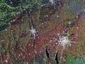
English: This image from Sentinel-1A’s radar captures part of Germany’s state of Bavaria, with the city of Munich on the right and Augsburg at the centre.
Munich is located on the elevated plains just north of the Alps. Zooming in, we can clearly see the river Isar running through the city. Along the northern part of this river, the white radar reflections from buildings give way to an elongated area of vegetation. This is the English Garden, a public park created in 1789 with an informal landscape of a style that was popular in Britain from the mid-18th century to the early 19th century. With an area of over 3.5 sq km, it is one of the world’s largest urban public parks. Outside the city – particularly to the east and south – we can see circular areas cut out of the forest to make space for villages. The landscape across this area was shaped by glaciers, including the two large lakes south of Munich – Lake Starnberg to the east and Ammersee to the west – that are the results of ice-age glaciers melting. Lake Starnberg is a popular recreation area for Munich, and has been named a wetland of international importance by the Ramsar Convention. The Convention is an intergovernmental treaty for the sustainable use of wetlands. This image, also featured on theEarth from Space video programme, combines three radar scans from the Sentinel-1A satellite in March and April 2015. |
| Дата | |
| Източник | http://www.esa.int/spaceinimages/Images/2015/07/Southern_Bavaria |
| Автор | European Space Agency |
| Права (Повторно използване на файла) |
Copernicus Sentinel data (2015)/ESA,CC BY-SA 3.0 IGO |
| други версии |
|
| Title | Southern Bavaria |
| Set | Earth observation image of the week |
| System | Copernicus |
| Mission | Sentinel-1 |
| Location | Germany |
| Activity | Observing the Earth |
| Keywords | City |
Лицензиране
- Можете свободно:
- да споделяте – да копирате, разпространявате и излъчвате произведението
- да ремиксирате – да адаптирате произведението
- Съгласно следните условия:
- признание на авторството – Трябва да посочите авторството, да добавите връзка към лиценза и да посочите дали са правени промени. Можете да направите това по всякакъв разумен начин, но не и по начин, оставящ впечатлението, че същият/същите подкрепят вас или използването по някакъв начин на творбата от вас.
- споделяне на споделеното – В случай, че промените, видоизмените или използвайки като основа произведението, го надградите, то полученото производно произведение може да се разпространява само съгласно условията на същия или съвместим лиценз с оригиналния такъв.

|
This image contains data from a satellite in the Copernicus Programme, such as Sentinel-1, Sentinel-2 or Sentinel-3. Attribution is required when using this image.
Признание: Contains modified Copernicus Sentinel data {{{year}}}
The use of Copernicus Sentinel Data is regulated under EU law (Commission Delegated Regulation (EU) No 1159/2013 and Regulation (EU) No 377/2014). Relevant excerpts:
Free access shall be given to GMES dedicated data [...] made available through GMES dissemination platforms [...].
Access to GMES dedicated data [...] shall be given for the purpose of the following use in so far as it is lawful:
GMES dedicated data [...] may be used worldwide without limitations in time.
GMES dedicated data and GMES service information are provided to users without any express or implied warranty, including as regards quality and suitability for any purpose. |
История на файла
Избирането на дата/час ще покаже как е изглеждал файлът към онзи момент.
| Дата/Час | Миникартинка | Размер | Потребител | Коментар | |
|---|---|---|---|---|---|
| текуща | 01:20, 8 май 2017 | | 1920 × 1434 (5,56 МБ) | Fæ | European Space Agency, Id 344112, http://www.esa.int/spaceinimages/Images/2015/07/Southern_Bavaria, User:Fæ/Project_list/ESA |
Използване на файла
Следната страница използва следния файл:
Глобално използване на файл
Този файл се използва от следните други уикита:
- Употреба в www.wikidata.org