
Файл:Via Appia.jpg

Оригинален файл (1271 × 442 пиксела, големина на файла: 216 КБ, MIME-тип: image/jpeg)
| Този файл е от Общомедия и може да се използва от други проекти.
Следва информация за файла, достъпна през оригиналната му описателна страница. |
| Описание |
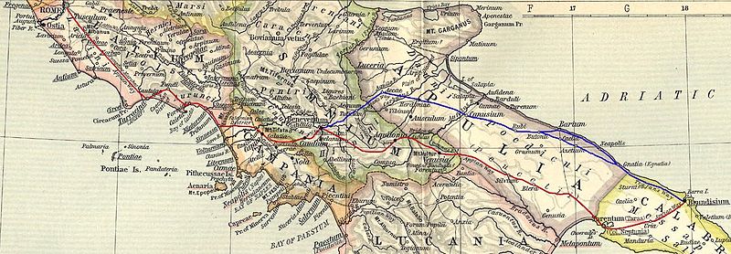
English: Ancient roman Appia road (from a William R. Shepherd 1911 map). The original track is in red color. In blue color a subsequent parallel track built under Traiano emperor and named Appia Traiana Italiano: Via Appia Antica (su mappa di William R. Shepherd, 1911). In colore rosso il tracciato originario, in blu l'Appia Traiana |
||||
| Дата | |||||
| Източник |
Based on a map from "Historical Atlas" by William R. Shepherd, New York, Henry Holt and Company, 1923 now in Public Domain. Reference: Reference Map of Ancient Italy, Southern Part Courtesy of the University of Texas Libraries, The University of Texas at Austin. [1] |
||||
| Автор | EH101 | ||||
| Права (Повторно използване на файла) |
|
||||
![[1]](http://www.lib.utexas.edu/maps/historical/shepherd_1911/shepherd-c-030-031.jpg)
История на файла
Избирането на дата/час ще покаже как е изглеждал файлът към онзи момент.
| Дата/Час | Миникартинка | Размер | Потребител | Коментар | |
|---|---|---|---|---|---|
| текуща | 14:58, 15 март 2012 | 1271 × 442 (216 КБ) | EH101 | Fixed error from this message: The Via Appia Antica after Minturnae doesn't cross Suessa, Teanum Sidicinum, Cales (there was the end of the Via Latina), but cross the ancient city of Sinuessa and then reach Casilinum. --DenghiùComm (talk) 09:57, 14 J... | |
| 21:15, 7 март 2008 | 1314 × 435 (215 КБ) | EH101 | {{Information |Description={{en|Ancient roman Appia road (from a William R. Shepherd 1911 map). The original track is in red color. In blue color a subsequent parallel track built under Traiano emperor and named Appia Traiana}} {{it|Via Appia Antica (su m | ||
| 20:55, 16 май 2007 | 1304 × 391 (165 КБ) | EH101 | |||
| 23:51, 13 февруари 2006 | 1304 × 391 (158 КБ) | Ilario | {{it|Via Appia Antica (su mappa di William R. Shepherd, 1911)}} Category:Rivers in Switzerland |
Използване на файла
Следната страница използва следния файл:
Глобално използване на файл
Този файл се използва от следните други уикита:
- Употреба в da.wikipedia.org
- Употреба в es.wikipedia.org
- Употреба в fr.wikipedia.org
- Употреба в it.wikipedia.org
- Употреба в la.wikipedia.org
- Употреба в pt.wikipedia.org
- Употреба в ro.wikipedia.org
- Употреба в sv.wikipedia.org