
Файл:West Mediterranean areas 348BC-fr.svg

Размер на този PNG предварителен преглед на изходния SVG файл: 800 × 402 пиксела. Други разделителни способности: 320 × 161 пиксела | 640 × 322 пиксела | 1024 × 515 пиксела | 1280 × 643 пиксела | 2560 × 1286 пиксела | 812 × 408 пиксела.
Оригинален файл (Файл във формат SVG, основен размер: 812 × 408 пиксела, големина на файла: 1,12 МБ)
| Този файл е от Общомедия и може да се използва от други проекти.
Следва информация за файла, достъпна през оригиналната му описателна страница. |
| Описание |
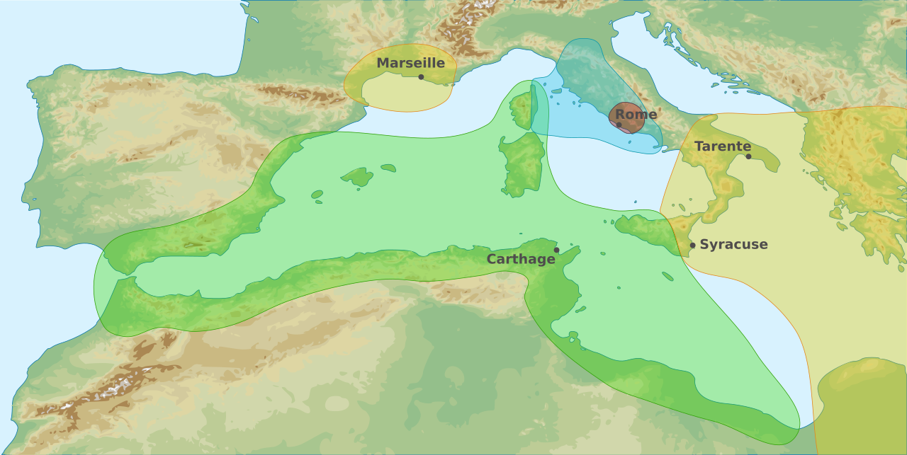
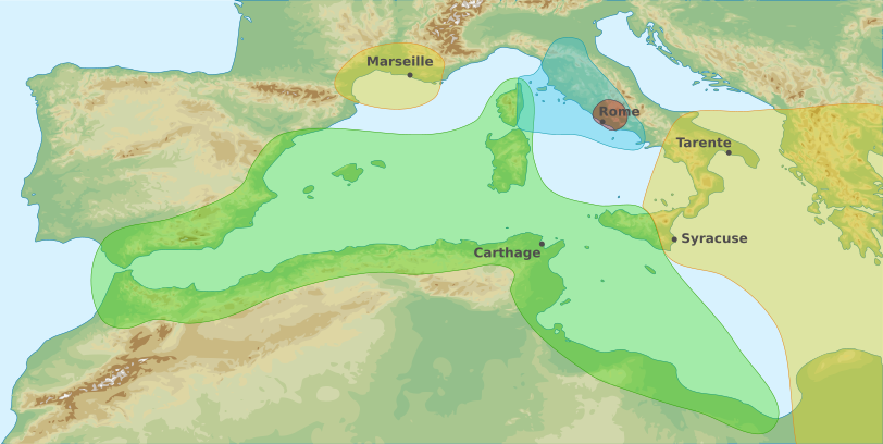
English: Map of area of influences in the Western Mediterranean Sea in 348 BC Français : Carte des zones d'influences dans l'Ouest de la Mer Méditerranée en 348 av. J-C Carthaginois Étrusques Grecs Romains |
| Дата | (UTC) |
| Източник | |
| Автор |
|
| други версии |
|
.svg)

Français : Cette carte a été créée par Pethrus d'après les sources mentionnés ci-dessus. Il s'agit d'un travail d'amateur, même s'il a été réalisé avec soin ; il peut comporter des inexactitudes ou des erreurs. Cette carte a donc un rôle d'illustration et non de référence. N'hésitez pas à me signaler toute erreur que vous constateriez ou à effectuer vous-même la correction. English: This map was drawn by Pethrus from sources mentionned above. Even if it was done with care, this is an amateur work ; there might be some inaccuracies or errors. As such, it should not be considered authoritative. Please contact me if you notice any mistake, and feel free to correct it yourself.
|

|
This SVG file contains embedded text that can be translated into your language, using any capable SVG editor, text editor or the SVG Translate tool. For more information see: About translating SVG files. |
Аз, носителят на авторските права над тази творба, я публикувам тук под следните лицензи:
Този файл се разпространява под лиценза Криейтив Комънс Признание - Споделяне на споделеното 3.0 Нелокализиран, 2.5 Неадаптиран, 2.0 Неадаптиран и 1.0 Неадаптиран.
- Можете свободно:
- да споделяте – да копирате, разпространявате и излъчвате произведението
- да ремиксирате – да адаптирате произведението
- Съгласно следните условия:
- признание на авторството – Трябва да посочите авторството, да добавите връзка към лиценза и да посочите дали са правени промени. Можете да направите това по всякакъв разумен начин, но не и по начин, оставящ впечатлението, че същият/същите подкрепят вас или използването по някакъв начин на творбата от вас.
- споделяне на споделеното – В случай, че промените, видоизмените или използвайки като основа произведението, го надградите, то полученото производно произведение може да се разпространява само съгласно условията на същия или съвместим лиценз с оригиналния такъв.

|
Предоставя се разрешение за копиране, разпространение и/или модификация на този документ според Лиценза за свободна документация на ГНУ, в своята версия 1.2 или някоя следваща версия, издадена от Фондацията за свободен софтуер; без непроменими раздели, без текст на предната подвързия и без текст на задната подвързия. Копие на този лиценз е приложено в раздела Лиценз за свободна документация на ГНУ. |
Можете да изберете лиценз по Ваш избор.
Дневник на оригиналното качване
This image is a derivative work of the following images:
- File:West_Mediterranean_Areas_348_BC.png licensed with PD-user
- 2006-07-14T09:22:39Z Horatius 1340x937 (2173031 Bytes) == Summary == Main areas of influence in West Mediterranean Sea in 348 BC. Principali aree di influenza nel Mediterraneo Occidentale nell'anno 348 aC (Secondo Trattato Roma-Cartagine). == Licensing == {{PD-user|Horatius}}
- File:West_Mediterranean_sea_topographic_map.svg licensed with Cc-by-sa-3.0,2.5,2.0,1.0, GFDL
- 2010-03-23T22:50:18Z Pethrus 812x408 (1161860 Bytes) {{Information |Description={{en|1=Topographic map of Western Mediterranean Sea}}{{fr|1=Carte topographique de l'Ouest de la Mer Méditerranée}} |Source=*[[:File:Western_Europe_DEMIS_topographic_map.svg|]], a DEMIS map {{inks
Uploaded with derivativeFX
История на файла
Избирането на дата/час ще покаже как е изглеждал файлът към онзи момент.
| Дата/Час | Миникартинка | Размер | Потребител | Коментар | |
|---|---|---|---|---|---|
| текуща | 21:16, 24 март 2010 | | 812 × 408 (1,12 МБ) | Pethrus | {{Information |Description={{en|1=Map of area of influences in the Western Mediterranean Sea in 348 BC}}{{fr|1=Carte des zones d'influences dans l'Ouest de la Mer Méditerranée en 348 av. J-C {{legend|#A3EBA9|Carthaginois}}{{legend|#9BE1F5|Étrusques}}{{ |
Използване на файла
Следната страница използва следния файл:
Глобално използване на файл
Този файл се използва от следните други уикита:
- Употреба в fr.wikipedia.org
- Употреба в it.wikipedia.org