
Файл:WielkoPolska epoki Piastowskiej.jpg

Оригинален файл (4075 × 3613 пиксела, големина на файла: 10,46 МБ, MIME-тип: image/jpeg)
| Този файл е от Общомедия и може да се използва от други проекти.
Следва информация за файла, достъпна през оригиналната му описателна страница. |
Резюме
| Описание |
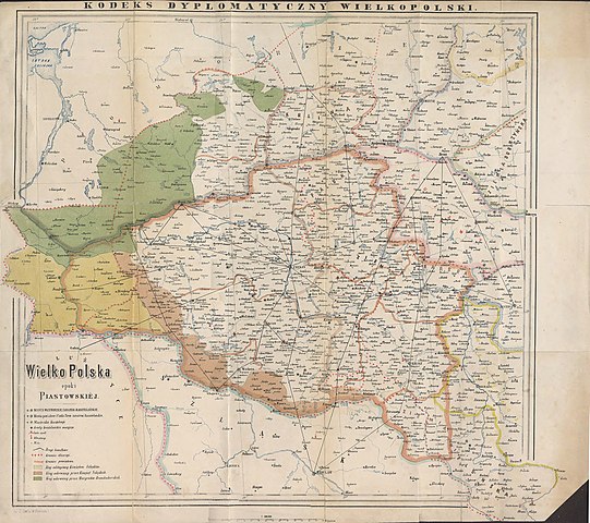
English: Historical map of Greater Poland (Middle Ages) made by Dr. T. Szulc and included in the 4th volume of Codex diplomaticus Maioris Poloniae
Polski: Historyczna mapa Wielkopolski w epoce piastowskiej wykonana przez Dr. T. Szulca i zamieszczona w 4. tomie Kodeksu dyplomatycznego Wielkopolski |
| Дата | |
| Източник | Kodeks dyplomatyczny Wielkopolski obejmujący dokumenta tak już drukowane, jak dotąd nie ogłoszone, sięgające do roku 1400, t.4, Poznań 1881 - Mapa Wielkopolski |
| Автор | Dr. T. Szulc |
| други версии | Derivative works of this file: Land given up to Silesian dukes (Dr. T. Szulc).jpg |
.jpg)
Лицензиране
|
Това произведение е обществено достояние в държавите, в които срокът на авторското право е 70 години или по-малко след смъртта на автора.
| |
| This file has been identified as being free of known restrictions under copyright law, including all related and neighboring rights. | |
История на файла
Избирането на дата/час ще покаже как е изглеждал файлът към онзи момент.
| Дата/Час | Миникартинка | Размер | Потребител | Коментар | |
|---|---|---|---|---|---|
| текуща | 15:28, 22 юни 2009 | | 4075 × 3613 (10,46 МБ) | Paelius | {{Information |Description={{en|1=Historical map of Greater Poland (Middle Ages) made by Dr. T. Szulc and included in the 4th volume of Codex diplomaticus Maioris Poloniae}} {{pl|1=Historyczna mapa Wielkopolski w epoce piastowskiej wykonana przez Dr. T. S |
Използване на файла
Следната страница използва следния файл:
Глобално използване на файл
Този файл се използва от следните други уикита:
- Употреба в azb.wikipedia.org
- Употреба в ca.wikipedia.org
- Употреба в cs.wikipedia.org
- Употреба в da.wikipedia.org
- Употреба в de.wikipedia.org
- Употреба в dsb.wikipedia.org
- Употреба в el.wikipedia.org
- Употреба в en.wikipedia.org
- Употреба в es.wikipedia.org
- Употреба в et.wikipedia.org
- Употреба в fa.wikipedia.org
- Употреба в hr.wikipedia.org
- Употреба в mk.wikipedia.org
- Употреба в nl.wikipedia.org
- Употреба в no.wikipedia.org
- Употреба в pl.wikipedia.org
- Piła (miasto)
- Głogów
- Wielkopolska
- Jarocin
- Sieraków
- Władysław Odonic
- Bolesław Pobożny
- Lubusz
- Chwarszczany
- Nowa Marchia
- Międzyrzecz
- Świebodzin
- Wschowa
- Łagów (powiat świebodziński)
- Powiat wałecki
- Powiat górowski
- Powiat milicki
- Powiat międzyrzecki
- Międzychód
- Odolanów
- Opole (średniowiecze)
- Osieczna
- Buk (miasto)
- Zamek w Międzyrzeczu
- Kościan
Преглед на глобалната употреба на файла.