
Файл:California map showing Lake County.png
Не е налична версия с по-висока разделителна способност.
California_map_showing_Lake_County.png (200 × 231 пиксела, големина на файла: 22 КБ, MIME-тип: image/png)
| Този файл е от Общомедия и може да се използва от други проекти.
Следва информация за файла, достъпна през оригиналната му описателна страница. |
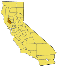
Map of Lake county in California. From en:

|
Предоставя се разрешение за копиране, разпространение и/или модификация на този документ според Лиценза за свободна документация на ГНУ, в своята версия 1.2 или някоя следваща версия, издадена от Фондацията за свободен софтуер; без непроменими раздели, без текст на предната подвързия и без текст на задната подвързия. Копие на този лиценз е приложено в раздела Лиценз за свободна документация на ГНУ. |
| Този файл се разпространява под лиценз Криейтив Комънс Признание — Споделяне на споделеното 3.0. | ||
| ||
| This licensing tag was added to this file as part of the GFDL licensing update. |
История на файла
Избирането на дата/час ще покаже как е изглеждал файлът към онзи момент.
| Дата/Час | Миникартинка | Размер | Потребител | Коментар | |
|---|---|---|---|---|---|
| текуща | 17:03, 1 юли 2005 | | 200 × 231 (22 КБ) | Pyramide~commonswiki | Map of Lake county in California. From en: {{GFDL}} Category:Maps of counties in California |
Използване на файла
Следната страница използва следния файл:
Глобално използване на файл
Този файл се използва от следните други уикита:
- Употреба в en.wikipedia.org
- Stone House (Lake County, California)
- Old Lake County Courthouse (California)
- Rattlesnake Island (Clear Lake)
- Template:LakeCountyCA-geo-stub
- Forbes Creek (California)
- Clear Lake Volcanic Field
- Loch Lomond, California
- Whispering Pines, California
- Little Blue Peak
- Clearlake Highlands, California
- Buckingham Park, California
- Clearlake Park, California
- Dahnohabe, California
- Finley, California
- Glenhaven, California
- Guenoc, California
- Harbin Springs, California
- Hullville, California
- Khawina, California
- Koi, California
- Lolsel, California
- Olposel, California
- Parramore Springs
- Pine Grove, Lake County, California
- Hopitsewah, California
- Timber Lake (Lake County, California)
- Eastlake Landfill
- Great Western Mine (Lake County, California)
- Jericho Creek (Hunting Creek tributary)
- The Jams
- Seigler Canyon Creek
- Highland Springs Reservoir
- Hidden Valley Lake (California)
- Thurston Lake
- Adobe Reservoir
- Adobe Creek (Lake County, California)
- St. Helena Toll Road and Bull Trail
- Употреба в li.wikipedia.org
- Употреба в pam.wikipedia.org
- Употреба в www.wikidata.org