
Файл:Canada2.A2002165.1940.250m.jpg

Размер на този преглед: 461 × 599 пиксела. Други разделителни способности: 184 × 240 пиксела | 369 × 480 пиксела | 591 × 768 пиксела | 788 × 1024 пиксела | 1575 × 2048 пиксела | 4000 × 5200 пиксела.
Оригинален файл (4000 × 5200 пиксела, големина на файла: 2,83 МБ, MIME-тип: image/jpeg)
| Този файл е от Общомедия и може да се използва от други проекти.
Следва информация за файла, достъпна през оригиналната му описателна страница. |
Резюме
| Описание |
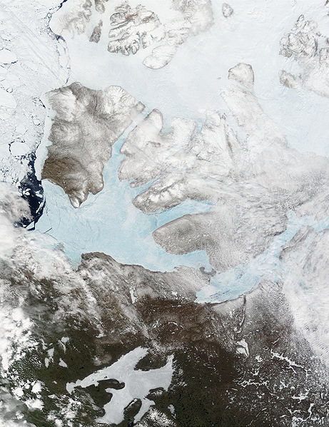
English: These Moderate resolution Imaging Spectroradiometer Images from June 14 and 16, 2002, show Banks Island (upper left) and Victoria Island (to the southeast) in the Arctic Ocean off northwest Canada. Left of center in each image is Amundsen Gulf, looking bright blue as this arm of the Beaufort Sea (at the southern end of the Arctic Ocean) begins to thaw. At the bottom of the images, the tundra of the Northwest Territories (left) and the Nunavut (right) Provinces of Canada is beginning to lose its winter snow cover. At bottom center of the portrait oriented image is Great Bear lake--still frozen. |
| Дата | June 14 and 16, 2002 |
| Източник | http://visibleearth.nasa.gov/view_rec.php?id=3342 |
| Автор | Jacques Descloitres, MODIS Land Rapid Response Team, NASA/GSFC |
Лицензиране
| This file is in the public domain in the United States because it was solely created by NASA. NASA copyright policy states that "NASA material is not protected by copyright unless noted". (See Template:PD-USGov, NASA copyright policy page or JPL Image Use Policy.) | ||
 |
Warnings:
|
История на файла
Избирането на дата/час ще покаже как е изглеждал файлът към онзи момент.
| Дата/Час | Миникартинка | Размер | Потребител | Коментар | |
|---|---|---|---|---|---|
| текуща | 17:59, 20 август 2008 | | 4000 × 5200 (2,83 МБ) | Ando228 | {{Information |Description={{en|1=These Moderate resolution Imaging Spectroradiometer Images from June 14 and 16, 2002, show Banks Island (upper left) and Victoria Island (to the southeast) in the Arctic Ocean off northwest Canada. Left of center in each |
Използване на файла
Следната страница използва следния файл:
Глобално използване на файл
Този файл се използва от следните други уикита:
- Употреба в af.wikipedia.org
- Употреба в ar.wikipedia.org
- Употреба в ast.wikipedia.org
- Употреба в az.wikipedia.org
- Употреба в be.wikipedia.org
- Употреба в bn.wikipedia.org
- Употреба в ca.wikipedia.org
- Употреба в ceb.wikipedia.org
- Употреба в cy.wikipedia.org
- Употреба в da.wikipedia.org
- Употреба в de.wikivoyage.org
- Употреба в diq.wikipedia.org
- Употреба в en.wikipedia.org
- Употреба в es.wikipedia.org
- Употреба в eu.wikipedia.org
- Употреба в fa.wikipedia.org
- Употреба в fi.wikipedia.org
- Употреба в fr.wikipedia.org
- Употреба в fr.wikivoyage.org
- Употреба в fy.wikipedia.org
- Употреба в ga.wikipedia.org
- Употреба в gl.wikipedia.org
- Употреба в he.wikipedia.org
- Употреба в hu.wikipedia.org
- Употреба в hy.wikipedia.org
- Употреба в ilo.wikipedia.org
- Употреба в is.wikipedia.org
- Употреба в it.wikipedia.org
- Употреба в ja.wikipedia.org
- Употреба в ko.wikipedia.org
- Употреба в ku.wikipedia.org
- Употреба в la.wikipedia.org
- Употреба в lv.wikipedia.org
- Употреба в ml.wikipedia.org
- Употреба в mzn.wikipedia.org
- Употреба в nl.wikipedia.org
- Употреба в nn.wikipedia.org
Преглед на глобалната употреба на файла.