
Файл:GreaterAmericaMap.jpg

Размер на този преглед: 800 × 558 пиксела. Други разделителни способности: 320 × 223 пиксела | 640 × 446 пиксела | 1024 × 714 пиксела | 1280 × 893 пиксела | 1537 × 1072 пиксела.
Оригинален файл (1537 × 1072 пиксела, големина на файла: 325 КБ, MIME-тип: image/jpeg)
| Този файл е от Общомедия и може да се използва от други проекти.
Следва информация за файла, достъпна през оригиналната му описателна страница. |

|
Това изображение (или всички изображения в тази страница/категория) би трябвало да бъдат пресъздадени с използване на векторна графика във формат SVG. Това има няколко предимства; вижте Commons:Media for cleanup за повече информация. Ако разполагате с това избражение в SVG формат, моля качете го. След това заместете този шаблон с {{Vector version available|име на новия файл.svg}}.
|


Резюме
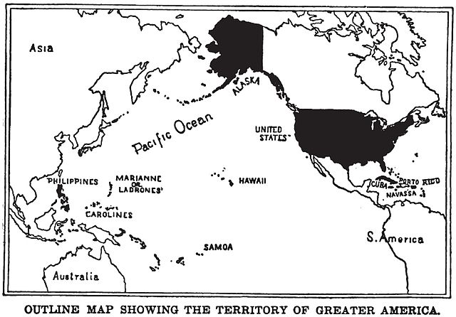
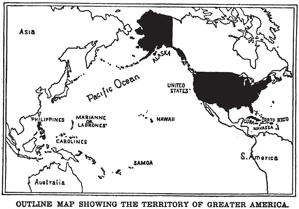
English: Map of "Greater America", 1899.
Shows territories and possessions of the United States after the Spanish American War, including Alaska, Cuba, Hawaii, Marianas, Philippines, Puerto Rico, and Samoa in addition to the continental United States.
Printed in book "War in the Philippines" by Marshall Everet.
Scanned from original 1899 printing by Infrogmation, previously uploaded by him to en:Wikipedia 23:36, 22 October 2003
en:Image:GreaterAmericaMap.jpg
Лицензиране
This media file is in the public domain in the United States. This applies to U.S. works where the copyright has expired, often because its first publication occurred prior to January 1, 1929, and if not then due to lack of notice or renewal. See this page for further explanation.
|
 | |
 |
This image might not be in the public domain outside of the United States; this especially applies in the countries and areas that do not apply the rule of the shorter term for US works, such as Canada, Mainland China (not Hong Kong or Macao), Germany, Mexico, and Switzerland. The creator and year of publication are essential information and must be provided. See Wikipedia:Public domain and Wikipedia:Copyrights for more details.
|
История на файла
Избирането на дата/час ще покаже как е изглеждал файлът към онзи момент.
| Дата/Час | Миникартинка | Размер | Потребител | Коментар | |
|---|---|---|---|---|---|
| текуща | 22:17, 24 август 2010 | | 1537 × 1072 (325 КБ) | Quazgaa | Higher Res |
| 12:55, 23 май 2005 |  | 571 × 391 (70 КБ) | Shizhao | Map of "Greater America", scanned from 1899 book. Shows territories and possessions of the United States after the Spanish American War, including Alaska, Cuba, Hawaii, Marianas, Philippines, Puerto Rico, and Samoa |
Използване на файла
Няма страници, използващи файла.
Глобално използване на файл
Този файл се използва от следните други уикита:
- Употреба в ba.wikipedia.org
- Употреба в be.wikipedia.org
- Употреба в da.wikipedia.org
- Употреба в en.wikipedia.org
- Употреба в en.wikibooks.org
- Употреба в en.wikiquote.org
- Употреба в es.wikipedia.org
- Употреба в fa.wikipedia.org
- Употреба в fr.wikipedia.org
- Употреба в hu.wikipedia.org
- Употреба в hy.wikipedia.org
- Употреба в id.wikipedia.org
- Употреба в it.wikipedia.org
- Употреба в ja.wikipedia.org
- Употреба в ko.wikipedia.org
- Употреба в nl.wikipedia.org
- Употреба в no.wikipedia.org
- Употреба в pl.wikipedia.org
- Употреба в pt.wikipedia.org
- Употреба в ru.wikipedia.org
- Употреба в tt.wikipedia.org
- Употреба в uk.wikipedia.org
- Употреба в vi.wikipedia.org
- Употреба в zh.wikipedia.org