
Файл:Munster Tabula Novarum Insularum 1540 UTA.jpg

Размер на този преглед: 777 × 600 пиксела. Други разделителни способности: 311 × 240 пиксела | 622 × 480 пиксела | 995 × 768 пиксела | 1280 × 988 пиксела | 2560 × 1975 пиксела | 3674 × 2835 пиксела.
Оригинален файл (3674 × 2835 пиксела, големина на файла: 1,93 МБ, MIME-тип: image/jpeg)
| Този файл е от Общомедия и може да се използва от други проекти.
Следва информация за файла, достъпна през оригиналната му описателна страница. |
Резюме
| Заглавие |
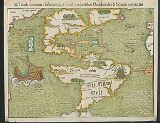
Latina: Tabula Novarum Insularum |
||||||||||||||||||||||||||
| Description |
English: Religion and politics are often closely allied, and this was especially the case in the sixteenth century. In this famous map, the Spanish flag flies prominently in the West Indies, while the Portuguese flag dominates the south Atlantic – reflecting pronouncements by Pope Alexander VI in 1493 and the Treaty of Tordesillas between Spain and Portugal of 1494. These declarations divided the non-Christian world between the two countries and charged the Portuguese and Spanish rulers with the responsibility of bringing the non-Christian inhabitants into the Catholic faith. This is reputedly the first printed map to name the Pacific Ocean and it is also among the earliest printed maps of the Western Hemisphere to show North and South America as separate but connected landmasses. The map’s creator, Münster, was a German Catholic Franciscan theologian and priest (ordained in 1512) as well as cartographer, cosmographer, humanist, mathematician, and scholar. |
||||||||||||||||||||||||||
| Дата | |||||||||||||||||||||||||||
| Източник | UTA Libraries Cartographic Connections: географска карта / text | ||||||||||||||||||||||||||
| Създател |
|
||||||||||||||||||||||||||
| Произход |
English: UTA Libraries Special Collections |
||||||||||||||||||||||||||
| Geotemporal data | |||||||||||||||||||||||||||
| Map location | Америка | ||||||||||||||||||||||||||
| Georeferencing | If inappropriate please set warp_status = skip to hide. | ||||||||||||||||||||||||||
| Bibliographic data | |||||||||||||||||||||||||||
| Публикация |
Geographia Universalis |
||||||||||||||||||||||||||
| Автор |
|
||||||||||||||||||||||||||
| Място на издаване | Базел | ||||||||||||||||||||||||||
| Printed by |
|
||||||||||||||||||||||||||
| Archival data | |||||||||||||||||||||||||||
| Колекция |
|
||||||||||||||||||||||||||
| Размери | Височина: 27,5 cm; ширина: 34,5 cm | ||||||||||||||||||||||||||
| Медия | colored engraving on paper | ||||||||||||||||||||||||||
| artwork-references |
Burden The Mapping of North America, no. 12 , pp. 15−17 Martin и Martin Maps of Texas and the Southwest, 1513-1900, no. 2 , p. 67 |
||||||||||||||||||||||||||
.jpg)

Лицензиране

|
This file was provided to Wikimedia Commons by the University of Texas at Arlington Libraries as part of a cooperation project. The University of Texas at Arlington Libraries is part of the University of Texas at Arlington, a public research university located in Arlington, Texas.
|
|
Това произведение е обществено достояние в държавите, в които срокът на авторското право е 100 години или по-малко след смъртта на автора. Това произведение е обществено достояние в Съединените американски щати, защото е било публикувано преди 1 януари 1929 година. | |
| This file has been identified as being free of known restrictions under copyright law, including all related and neighboring rights. | |
История на файла
Избирането на дата/час ще покаже как е изглеждал файлът към онзи момент.
| Дата/Час | Миникартинка | Размер | Потребител | Коментар | |
|---|---|---|---|---|---|
| текуща | 18:23, 29 януари 2022 | | 3674 × 2835 (1,93 МБ) | Michael Barera | == {{int:filedesc}} == {{Map |title = {{la|'''''Tabula Novarum Insularum'''''}} |description = {{en|Religion and politics are often closely allied, and this was especially the case in the sixteenth century. In this famous map, the Spanish flag flies prominently in the West Indies, while the Portuguese flag dominates the south Atlantic – reflecting pronouncements by Pope Alexander VI in 1493 and the Treaty of Tordesillas between Spain and Portugal of 1494. These declaration... |
Използване на файла
Следната страница използва следния файл:
Глобално използване на файл
Този файл се използва от следните други уикита:
- Употреба в de.wikipedia.org
- Употреба в el.wikipedia.org
- Употреба в en.wikipedia.org
- Употреба в es.wikipedia.org
- Употреба в eu.wikipedia.org
- Употреба в fr.wikipedia.org
- Употреба в it.wikipedia.org
- Употреба в ru.wikipedia.org