
Файл:Podgorica Montenegro.png
Podgorica_Montenegro.png (525 × 599 пиксела, големина на файла: 456 КБ, MIME-тип: image/png)
| Този файл е от Общомедия и може да се използва от други проекти.
Следва информация за файла, достъпна през оригиналната му описателна страница. |
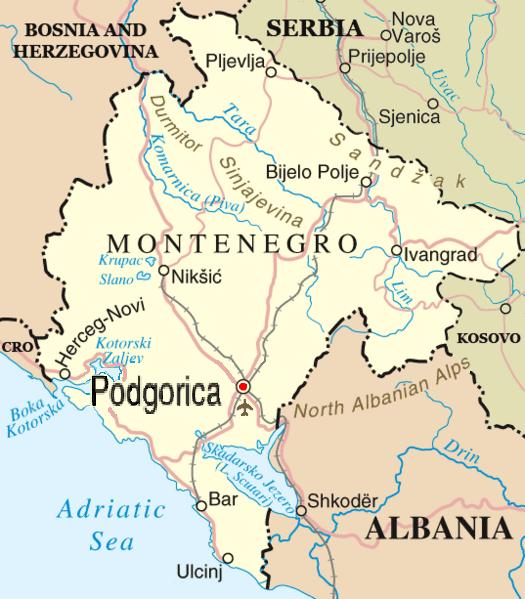
| Описание |
English: Map of en:Podgorica, en:Montenegro adapted by Madman from http://www.un.org/Depts/Cartographic/map/profile/yugoslav.pdf
by way of Image:Montenegro-bioce.png. |
| Дата | 28 януари 2006 (original upload date) |
| Източник | Прехвърлен от en.wikipedia към Общомедия от Drilnoth използвайки CommonsHelper. |
| Автор | The original uploader was Madman2001 at английски Уикипедия. |

|
Това изображение (или всички изображения в тази страница/категория) би трябвало да бъдат пресъздадени с използване на векторна графика във формат SVG. Това има няколко предимства; вижте Commons:Media for cleanup за повече информация. Ако разполагате с това избражение в SVG формат, моля качете го. След това заместете този шаблон с {{Vector version available|име на новия файл.svg}}.
|
Лицензиране
This file is in the public domain because permission given by UN as set out below
|
| This image is a map derived from a United Nations map.
Unless stated otherwise, UN maps are to be considered in the public domain. This applies worldwide. UN maps are, in principle, open source material and you can use them in your work or for making your own map. UN requests however that you delete the UN name, logo and reference number upon any modification to the map. Content of your map will be your responsibility. You can state in your publication, if you wish, something like: based on UN map … (map name, map number, revision number and date). See: Geospatial Information Section. And: Geospatial, location data for a better world. |
 |
Дневник на оригиналното качване
- 2006-01-28 05:42 Madman2001 525×599× (466813 bytes) Better map of [[Podgorica]]], [[Montenegro]], adapted and edited by [[User:Madman2001|Madman]] from http://www.un.org/Depts/Cartographic/map/profile/yugoslav.pdf by way of Image:Montenegro-bioce.png == {{int:license}} == {{PD-because|permission given by UN as
- 2006-01-08 05:25 Madman2001 1920×1440× (924096 bytes) Author: Madman compiled from a number of sources, including satellite photos with hand-drawn towns and borders
- 2006-01-07 22:43 Madman2001 1920×1440× (708202 bytes) Author: Madman, using public domain satellite imagery for the geographic outline, with hand-drawn border and towns
История на файла
Избирането на дата/час ще покаже как е изглеждал файлът към онзи момент.
| Дата/Час | Миникартинка | Размер | Потребител | Коментар | |
|---|---|---|---|---|---|
| текуща | 12:27, 31 март 2009 | | 525 × 599 (456 КБ) | File Upload Bot (Magnus Manske) | {{BotMoveToCommons|en.wikipedia|year={{subst:CURRENTYEAR}}|month={{subst:CURRENTMONTHNAME}}|day={{subst:CURRENTDAY}}}} {{Information |Description={{en|Map of en:Podgorica, en:Montenegro adapted by Madman from http://www |
Използване на файла
Няма страници, използващи файла.
Глобално използване на файл
Този файл се използва от следните други уикита:
- Употреба в sc.wikipedia.org