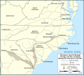
Файл:Shermans march through Georgia and the Carolinas map-en.svg

Съдържанието на страницата не се поддържа на други езици.
от Уикипедия, свободната енциклопедия

Оригинален файл(Файл във формат SVG, основен размер: 870 × 780 пиксела, големина на файла: 279 КБ)

Емблемата на Общомедия Този файл е от Общомедия и може да се използва от други проекти.

Следва информация за файла, достъпна през оригиналната му описателна страница.

 
W3C-validity not checked.

Резюме

Camera location35° 00′ 00″ N, 80° 00′ 00″ W Kartographer map based on OpenStreetMap.View this and other nearby images on: OpenStreetMapinfo


Описание
Français : Carte de la marche du général William Tecumseh Sherman à travers la Géorgie et les Carolines, durant la Guerre de Sécession.

UTM projection

Scale: 1:2,000,000
Дата
Източник

Собствена творба

Автор Eric Gaba (Sting - fr:Sting)
Права
(Повторно използване на файла)
Public domain
други версии

[редактиране]


Translate this file This SVG file contains embedded text that can be translated into your language, using any capable SVG editor, text editor or the SVG Translate tool. For more information see: About translating SVG files.

Лицензиране

Public domain This work was previously under Public Domain, or a Free License. It has been digitally enhanced and/or modified. This derivative work has been (or is hereby) released into the public domain by its author, Sting at the French Wikipedia project. This applies worldwide.

In some countries this is not legally possible; if so:
Sting grants anyone the right to use this work for any purpose, without any conditions, unless such conditions are required by law.


English  简体中文‎  繁體中文‎  +/−

Описания

Add a one-line explanation of what this file represents

Items portrayed in this file

изобразен обект

Някаква стойност без обект в Уикиданни

source of file английски

original creation by uploader английски

35°0'0.000"N, 80°0'0.000"W

История на файла

Избирането на дата/час ще покаже как е изглеждал файлът към онзи момент.

Дата/ЧасМиникартинкаРазмерПотребителКоментар
текуща14:22, 9 юли 2009Миникартинка на версията към 14:22, 9 юли 2009870 × 780 (279 КБ)StingOups ! A newbie error on the scale
04:04, 8 юли 2009Миникартинка на версията към 04:04, 8 юли 2009870 × 780 (279 КБ)Sting== Summary == {{Location|35|00|00|N|80|00|00|W|scale:3000000}} <br/> {{Information| |Description={{en|Map of Gen. William T. Sherman's march through Georgia and the Carolinas during the [

Няма страници, използващи файла.

Глобално използване на файл

Този файл се използва от следните други уикита: