
Файл:20040514 large hail 5.25".jpg

Оригинален файл (659 × 721 пиксела, големина на файла: 60 КБ, MIME-тип: image/jpeg)
| Този файл е от Общомедия и може да се използва от други проекти.
Следва информация за файла, достъпна през оригиналната му описателна страница. |
Резюме
| Описание |
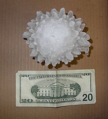
English: A large hailstone, approximately 133 mm (5 1/4 inches) in diameter, that fell in Harper, Kansas on May 14, 2004.
Français : Un grêlon de 133 mm de diamètre, tombé à Harper, dans le Kansas le 14 mai 2004. |
|||
| Дата | ||||
| Източник | http://www.crh.noaa.gov/ict/scripts/viewimage.php?STORY_NUMBER=2004051418&IMG_NUM=16&loc=local | |||
| Автор | National Weather Service - Wichita, Kansas | |||
| Права (Повторно използване на файла) |
|
| Object location | | View this and other nearby images on: OpenStreetMap |
|---|
Лицензиране
This image is in the public domain because it contains materials that originally came from the U.S. National Oceanic and Atmospheric Administration, taken or made as part of an employee's official duties.
|

|
Това изображение е оценено в съответствие с критериите за ценни изображения и е признато като най-ценната снимка в Общомедия в категорията Hailstone. Може да прегледате номинацията в Commons:Valued image candidates/20040514 large hail 5.25".jpg. |
История на файла
Избирането на дата/час ще покаже как е изглеждал файлът към онзи момент.
| Дата/Час | Миникартинка | Размер | Потребител | Коментар | |
|---|---|---|---|---|---|
| текуща | 11:08, 7 септември 2009 | | 659 × 721 (60 КБ) | Ks0stm | {{Information |Description={{en|1=A large hailstone, approximately 5 1/4 inches in diameter, that fell in Harper, Kansas on May 14, 2004}} |Source=http://www.crh.noaa.gov/ict/scripts/viewimage.php?STORY_NUMBER=2004051418&IMG_NUM=16&loc=local |Author=Natio |
Използване на файла
Следната страница използва следния файл:
Глобално използване на файл
Този файл се използва от следните други уикита:
- Употреба в beta.wikiversity.org
- Употреба в da.wikipedia.org
- Употреба в el.wikipedia.org
- Употреба в en.wikipedia.org
- Употреба в en.wikiversity.org
- Употреба в kbp.wikipedia.org
- Употреба в lv.wikipedia.org
- Употреба в mk.wikipedia.org
- Употреба в pl.wiktionary.org
- Употреба в pt.wikipedia.org
- Употреба в ta.wiktionary.org