
Файл:Chesapeake Bay Watershed.png
Не е налична версия с по-висока разделителна способност.
Chesapeake_Bay_Watershed.png (300 × 345 пиксела, големина на файла: 16 КБ, MIME-тип: image/png)
| Този файл е от Общомедия и може да се използва от други проекти.
Следва информация за файла, достъпна през оригиналната му описателна страница. |
Резюме
| Описание |
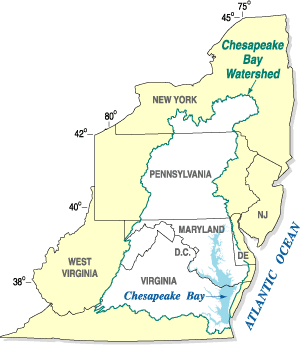
Български: Местообитанието на Часи.
Dansk: Vandskellet omkring Chesapeake Bay.
English: The Chesapeake Bay Watershed.
Español: Mapa de la cuenca hidrográfica de la bahía de Chesapeake (en blanco), mostrando los estados a los que drena.
Nederlands: Chesapeake Bay stroomgebied. English: Chesapeake Bay Watershed overlaid on political map of Mid-Atlantic states It is a large body of water |
| Източник | United States Geological Survey |
| Автор |
Лицензиране
Този материал е обществено достояние в Съединените Щати тъй като е дело на Федералното правителство на САЩ.
Забележка: Това не се отнася за материали, създадени от щатски правителства или местни органи на властта..
|
 | |
| This file has been identified as being free of known restrictions under copyright law, including all related and neighboring rights. | ||
Дневник на оригиналното качване
Прехвърлен от en.wikipedia към Общомедия от Hejsa.
The original description page was here. All following user names refer to en.wikipedia.
- 2008-01-31 01:59 Karma Heretic 300×345× (13443 bytes) {{Information |Description=Chesapeake Bay Watershed overlaid on political map of Mid-Atlantic states |Source=United States Geological Survey |Date=January 30, 2008 |Location=http://md.water.usgs.gov/publications/fs-091-03/html/location_big.gif |Author= |P
Дневник на оригиналното качване
| Дата/Час | Размер | Потребител | Коментар |
|---|---|---|---|
| 7 ноември 2008, 15:29:53 | 300 × 345 (13443 bytes) | Hejsa (беседа · приноси) | {{Information |Description={{en|Chesapeake Bay Watershed overlaid on political map of Mid-Atlantic states<br/> It is a large body of water}} |Source=Transferred from [http://en.wikipedia.org en.wikipedia]; transfer was stated to be made by [[User:Hejsa]]. |
История на файла
Избирането на дата/час ще покаже как е изглеждал файлът към онзи момент.
| Дата/Час | Миникартинка | Размер | Потребител | Коментар | |
|---|---|---|---|---|---|
| текуща | 15:29, 21 ноември 2014 | | 300 × 345 (16 КБ) | GifTagger | Bot: Converting file to superior PNG file. (Source: Chesapeake_Bay_Watershed.gif). This GIF was problematic due to transparency and non-greyscale color table. |
Използване на файла
Следната страница използва следния файл:
Глобално използване на файл
Този файл се използва от следните други уикита:
- Употреба в da.wikipedia.org
- Употреба в en.wikipedia.org
- Употреба в es.wikipedia.org
- Употреба в fy.wikipedia.org
- Употреба в nl.wikipedia.org
- Употреба в th.wikipedia.org