
Файл:GangesValley&Plain.jpg

Размер на този преглед: 800 × 559 пиксела. Други разделителни способности: 320 × 223 пиксела | 640 × 447 пиксела | 1024 × 715 пиксела | 1280 × 894 пиксела | 2165 × 1512 пиксела.
Оригинален файл (2165 × 1512 пиксела, големина на файла: 680 КБ, MIME-тип: image/jpeg)
| Този файл е от Общомедия и може да се използва от други проекти.
Следва информация за файла, достъпна през оригиналната му описателна страница. |
Резюме
| Описание |
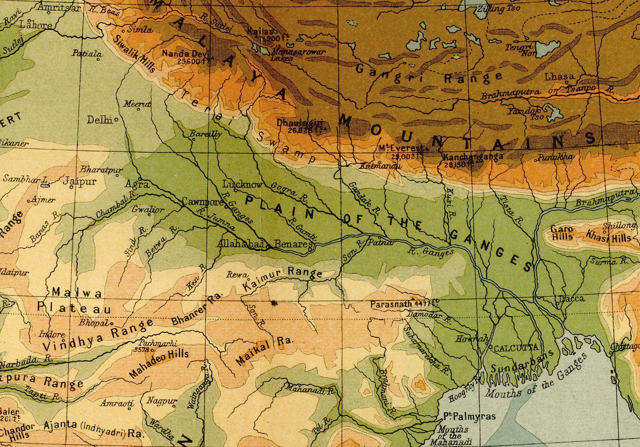
English: The Ganges river valley and plain as shown in a portion of the map, "India: Orthographical Features" from Imperial Gazetteer of India, volume 26, Atlas (Map Number 3) (1908). |
| Дата | |
| Източник | Imperial Gazetteer of India, volume 26, Atlas Scanned and cropped from personal copy by Fowler&fowler«Talk» |
| Автор | John Bartholomew and Sons, Edinburgh |
Лицензиране
This work created by the United Kingdom Government is in the public domain.
This is because it is one of the following:
HMSO has declared that the expiry of Crown Copyrights applies worldwide (ref: HMSO Email Reply)
|
 |
Дневник на оригиналното качване
Прехвърлен от en.wikipedia към Общомедия от Sreejithk2000 използвайки CommonsHelper.
The original description page was here. All following user names refer to en.wikipedia.
- 2009-03-29 22:18 Fowler&fowler 2165×1512× (696637 bytes) {{Information |Description = The [[Ganges]] river valley and plain as shown in a portion of the map, "[http://dsal.uchicago.edu/reference/gaz_atlas_1909/pager.html?object=10 India: Orographical Features]" from ''[http://dsal.uchicago.edu/reference/gaz_atlas_1909/ Imperial Gazetteer of India, volume 26, Atlas]'' (Map Number 3) (1908). Scanned and cropped from personal copy
История на файла
Избирането на дата/час ще покаже как е изглеждал файлът към онзи момент.
| Дата/Час | Миникартинка | Размер | Потребител | Коментар | |
|---|---|---|---|---|---|
| текуща | 17:00, 30 юни 2010 | | 2165 × 1512 (680 КБ) | File Upload Bot (Magnus Manske) | {{BotMoveToCommons|en.wikipedia|year={{subst:CURRENTYEAR}}|month={{subst:CURRENTMONTHNAME}}|day={{subst:CURRENTDAY}}}} {{Information |Description={{en|The en:Ganges river valley and plain as shown in a portion of the map, "India: Orthographical Fea |
Използване на файла
Следната страница използва следния файл:
Глобално използване на файл
Този файл се използва от следните други уикита:
- Употреба в as.wikipedia.org
- Употреба в ban.wikipedia.org
- Употреба в bh.wikipedia.org
- Употреба в bn.wikipedia.org
- Употреба в de.wikipedia.org
- Употреба в en.wikipedia.org
- Употреба в es.wikipedia.org
- Употреба в fr.wikipedia.org
- Употреба в ilo.wikipedia.org
- Употреба в ko.wikipedia.org
- Употреба в ku.wikipedia.org
- Употреба в kw.wikipedia.org
- Употреба в mn.wikipedia.org
- Употреба в nds.wikipedia.org
- Употреба в sk.wikipedia.org
- Употреба в sr.wikipedia.org
- Употреба в uk.wikipedia.org
- Употреба в zh.wikipedia.org