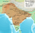
Файл:Maurya Empire, c.250 BCE 2.png

Съдържанието на страницата не се поддържа на други езици.
от Уикипедия, свободната енциклопедия

Оригинален файл(1200 × 1121 пиксела, големина на файла: 2,26 МБ, MIME-тип: image/png)

Емблемата на Общомедия Този файл е от Общомедия и може да се използва от други проекти.

Следва информация за файла, достъпна през оригиналната му описателна страница.

Резюме

Описание
English: Note: This was the standard "textbook" map of the Maurya Empire. Historians are now arguing that the Maurya Empire did not include large parts of India, which were controlled by autonomous tribes. For such a map, see File:Maurya Empire, c.250 BCE.png.
Alternative map of Maurya Empire

Boundaries are based on Charles Joppen Historical Atlas of India (1907), see File:India_in_250_B._C.jpg.

Other Sources:

Other sources:

  • Grainger, John D. (1990, 2014). Seleukos Nikator: Constructing a Hellenistic Kingdom. Routledge.
  • Keay, John (2000). India, a History. New York: Harper Collins Publishers.
  • Kulke, H.; Rothermund, D. (2004). A History of India, 4th, Routledge.
  • Puri, Baji Nath (1996). Buddhism in Central Asia. Delhi: Motilal Banarsidass.
  • Raychaudhuri, H. C.; Mukherjee, B. N. (1996). Political History of Ancient India: From the Accession of Parikshit to the Extinction of the Gupta Dynasty. Oxford University Press.
  • Stein, Burton (1998). A History of India (1st ed.), Oxford: Wiley-Blackwell.

Notes:

  • Sri Lanka and the southernmost parts of India (modern Tamil Nadu and Kerala) remained independent, despite the diplomacy and cultural influence of their larger neighbor to the north (Schwartzberg 1992, p. 18; Kulke & Rothermund 2004, p. 68).
  • The account of Strabo indicates that the western-most territory of the empire extended from the southeastern Hindu Kush, through the region of Kandahar, to coastal Baluchistan south of that (Raychaudhuri & Mukherjee 1996, p. 594).
  • The claim that Aria/Herat was one of the provinces (alongside Arachosia, Gedrosia, and Paropamisadae) ceded by Seleucus to Chandragupta Maurya is often repeated, but Aria (modern Herat) "has been wrongly included in the list of ceded satrapies by some scholars [...] on the basis of wrong assessments of the passage of Strabo [...] and a statement by Pliny." (Raychaudhuri & Mukherjee 1996, p. 594). Seleucus "must [...] have held Aria", and furthermore, his "son Antiochos was active there fifteen years later." (Grainger 2014, p. 109).
  • "The region of Aria is definitely known to have been Seleucid under Seleucus I and Antiochus I as it definitely was after Antiochus III's great campaign in the east against the Parthians and Bactrians. [...] There is no evidence whatever that it did not remain Seleucid, like Drangiana, with which it is linked by easy routes." -Susan M. Sherwin-White and Amélie Kuhrt (1993) From Samarkhand to Sardis: A New Approach to the Seleucid Empire, University of California Press, pp.79-80.
  • It is recorded that Drangiana province continued to be in the Seleucids' hands, as per [1].
  • "Desert of Gedrosia [...] was left an unclaimed wilderness." —Kosmin, Paul J. (2014), The Land of the Elephant Kings Space, Territory, and Ideology in the Seleucid Empire, Harvard University Press, p.16
  • Schwartzberg (p. 18) speculates about the Buddhist culture and Kharosthi inscriptions/manuscripts found in Khotan, but these texts from Khotan, Turfan, and Tajikstan have all been shown to be later than the 1st century BCE (Puri, p. 185).
Дата
Източник Собствена творба
Автор Avantiputra7

Лицензиране

Аз, носителят на авторските права над тази творба, я публикувам тук под следния лиценз:
w:bg:Криейтив Комънс
признание на авторството споделяне на споделеното
Този файл се разпространява под лиценз Криейтив Комънс Признание — Споделяне на споделеното 3.0.
Можете свободно:
  • да споделяте – да копирате, разпространявате и излъчвате произведението
  • да ремиксирате – да адаптирате произведението
Съгласно следните условия:
  • признание на авторството – Трябва да посочите авторството, да добавите връзка към лиценза и да посочите дали са правени промени. Можете да направите това по всякакъв разумен начин, но не и по начин, оставящ впечатлението, че същият/същите подкрепят вас или използването по някакъв начин на творбата от вас.
  • споделяне на споделеното – В случай, че промените, видоизмените или използвайки като основа произведението, го надградите, то полученото производно произведение може да се разпространява само съгласно условията на същия или съвместим лиценз с оригиналния такъв.

Описания

Add a one-line explanation of what this file represents

Някаква стойност без обект в Уикиданни

copyright status английски

copyrighted английски

source of file английски

original creation by uploader английски

media type английски

image/png

История на файла

Избирането на дата/час ще покаже как е изглеждал файлът към онзи момент.

(най-нови | най-стари) Преглед (по-нови 10 | ) (10 | 20 | 50 | 100 | 250 | 500).
Дата/ЧасМиникартинкаРазмерПотребителКоментар
текуща11:01, 30 април 2024Миникартинка на версията към 11:01, 30 април 20241200 × 1121 (2,26 МБ)Avantiputra7western borders: see talk page
04:37, 16 април 2024Миникартинка на версията към 04:37, 16 април 20241200 × 1121 (2,26 МБ)Avantiputra7Reverted to version as of 11:12, 5 April 2024 (UTC) - vandalism
07:37, 14 април 2024Миникартинка на версията към 07:37, 14 април 20241200 × 1121 (2,18 МБ)Layman7676Reverted to version as of 11:12, 4 April 2024 (UTC) The map you are publishing isn't based on wha vincient Arthur really said.
11:12, 5 април 2024Миникартинка на версията към 11:12, 5 април 20241200 × 1121 (2,26 МБ)Avantiputra7Reverted to version as of 08:27, 3 April 2024 (UTC) - vandalism
11:12, 4 април 2024Миникартинка на версията към 11:12, 4 април 20241200 × 1121 (2,18 МБ)Chakravartin1929Reverted to version as of 05:41, 26 March 2024 (UTC) This is the true map. It depicts The mauryan map accurately.
08:27, 3 април 2024Миникартинка на версията към 08:27, 3 април 20241200 × 1121 (2,26 МБ)Avantiputra7Reverted to version as of 11:06, 3 March 2024 (UTC)
05:41, 26 март 2024Миникартинка на версията към 05:41, 26 март 20241200 × 1121 (2,18 МБ)Chakravartin1929Reverted to version as of 09:06, 3 March 2024 (UTC)
11:06, 3 март 2024Миникартинка на версията към 11:06, 3 март 20241200 × 1121 (2,26 МБ)Avantiputra7Reverted to version as of 11:10, 29 January 2024 (UTC)
09:06, 3 март 2024Миникартинка на версията към 09:06, 3 март 20241200 × 1121 (2,18 МБ)Chakravartin1929Reverted to version as of 16:50, 14 December 2023 (UTC) This map is better.
11:10, 29 януари 2024Миникартинка на версията към 11:10, 29 януари 20241200 × 1121 (2,26 МБ)Avantiputra7tweaked
(най-нови | най-стари) Преглед (по-нови 10 | ) (10 | 20 | 50 | 100 | 250 | 500).

Следната страница използва следния файл:

Глобално използване на файл

Този файл се използва от следните други уикита:

Преглед на глобалната употреба на файла.

Метаданни