
Файл:B26055943A - A map of the East-Indies and the adjacent countries.jpg

Размер на този преглед: 800 × 509 пиксела. Други разделителни способности: 320 × 204 пиксела | 640 × 407 пиксела | 1024 × 652 пиксела | 1280 × 815 пиксела | 2560 × 1629 пиксела | 7509 × 4779 пиксела.
Оригинален файл (7509 × 4779 пиксела, големина на файла: 12,73 МБ, MIME-тип: image/jpeg)
| Този файл е от Общомедия и може да се използва от други проекти.
Следва информация за файла, достъпна през оригиналната му описателна страница. |
Резюме
| Описание |
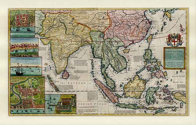
English: This large map by Herman Moll shows the East Indies from the Persian border to New Guinea and the southern part of Japan, including India, Ceylon, southeast Asia, most of China, Indonesia and the Philippines. It illustrates the extent of European influence and trade in the region, at the height of European colonial control. Further map features and detail maps of interest: Batavia, Goa, Mughal Empire, Maldives, Chennai, Banten, Lake Chimay |
| Дата | |
| Източник | NLB Singapore, David Parry Southeast Asian Map Collection. Available on BookSG https://eresources.nlb.gov.sg/printheritage/detail/3957ca10-8863-4f87-9d8c-49cfe590b0cd.aspx |
| Автор | Moll, Herman, -1732 |
| други версии |


Лицензиране
| Този файл е достъпен под лиценза Creative Commons CC0 1.0 Универсален Посвещение на публичните домейни. | |
| The person who associated a work with this deed has dedicated the work to the public domain by waiving all of their rights to the work worldwide under copyright law, including all related and neighboring rights, to the extent allowed by law. You can copy, modify, distribute and perform the work, even for commercial purposes, all without asking permission.
|
История на файла
Избирането на дата/час ще покаже как е изглеждал файлът към онзи момент.
| Дата/Час | Миникартинка | Размер | Потребител | Коментар | |
|---|---|---|---|---|---|
| текуща | 05:13, 28 декември 2021 | | 7509 × 4779 (12,73 МБ) | NLSingapore | Uploaded a work by Moll, Herman, -1732 from NLB Singapore, David Parry Southeast Asian Map Collection. Available on BookSG https://eresources.nlb.gov.sg/printheritage/detail/3957ca10-8863-4f87-9d8c-49cfe590b0cd.aspx with UploadWizard |
Използване на файла
Следната страница използва следния файл:
Глобално използване на файл
Този файл се използва от следните други уикита:
- Употреба в ar.wikipedia.org
- Употреба в ast.wikipedia.org
- Употреба в az.wikipedia.org
- Употреба в be.wikipedia.org
- Употреба в br.wikipedia.org
- Употреба в ca.wikipedia.org
- Употреба в cy.wikipedia.org
- Употреба в el.wikipedia.org
- Употреба в eo.wikipedia.org
- Употреба в eu.wikipedia.org
- Употреба в fr.wikipedia.org
- Употреба в ga.wikipedia.org
- Употреба в he.wikipedia.org
- Употреба в hy.wikipedia.org
- Употреба в it.wikipedia.org
- Употреба в sv.wikipedia.org
- Употреба в uk.wikipedia.org
- Употреба в www.wikidata.org