
Файл:Flemish Community in Belgium and Europe.svg

Размер на този PNG предварителен преглед на изходния SVG файл: 680 × 520 пиксела. Други разделителни способности: 314 × 240 пиксела | 628 × 480 пиксела | 1004 × 768 пиксела | 1280 × 979 пиксела | 2560 × 1958 пиксела.
Оригинален файл (Файл във формат SVG, основен размер: 680 × 520 пиксела, големина на файла: 2,38 МБ)
| Този файл е от Общомедия и може да се използва от други проекти.
Следва информация за файла, достъпна през оригиналната му описателна страница. |
Резюме
| Описание |
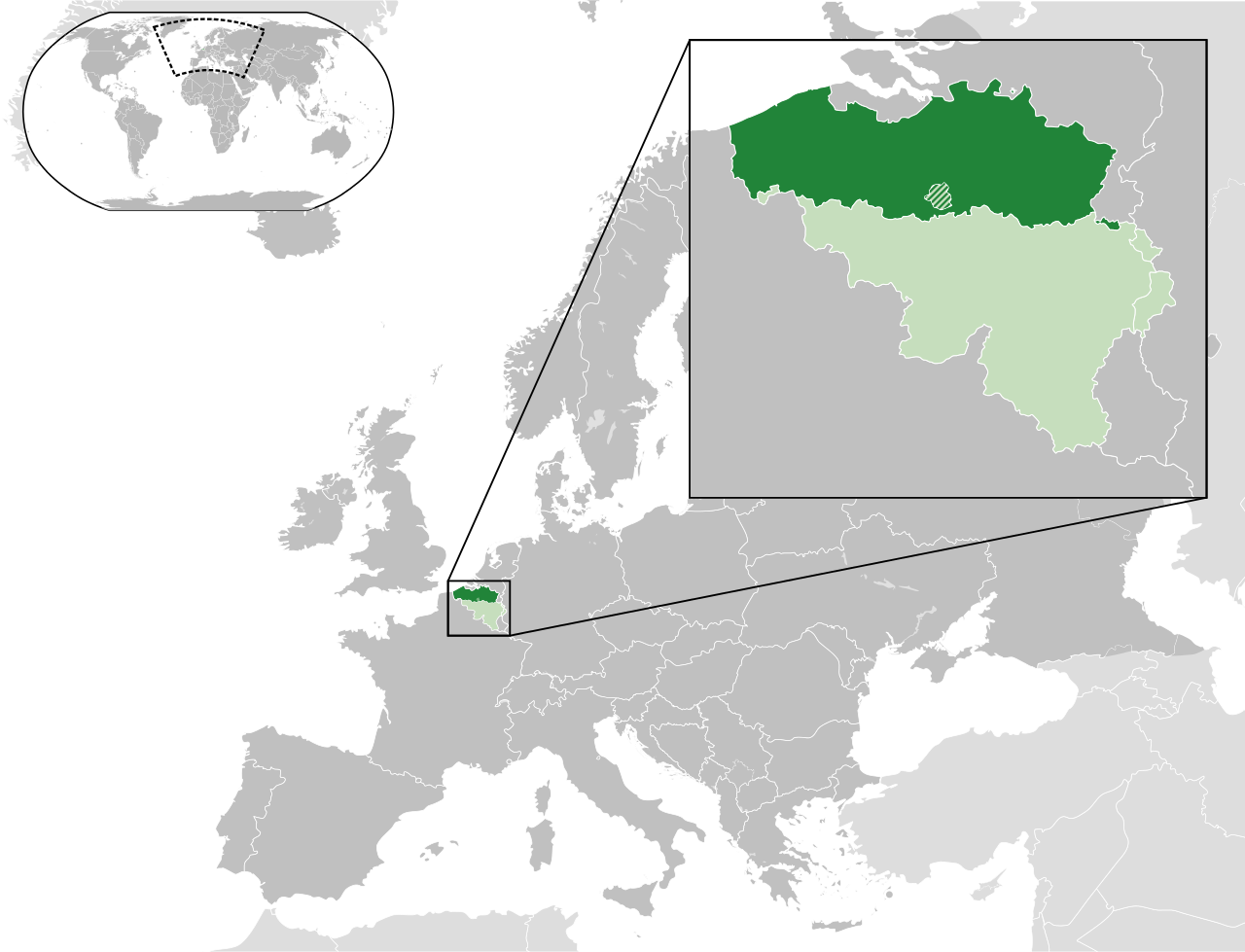
English: A map of the Flemish Community within Belgium and within Europe. Brussels, which is the capital of both the Flemish and French communities is shown with diagonal bars. |
| Дата | (UTC) |
| Източник |
This file was derived from: Blank map of Europe (with disputed regions).svg: |
| Автор |
|
| други версии |
|


.svg)
Лицензиране
Този файл се разпространява под лиценз Криейтив Комънс Признание — Споделяне на споделеното 3.0.
- Можете свободно:
- да споделяте – да копирате, разпространявате и излъчвате произведението
- да ремиксирате – да адаптирате произведението
- Съгласно следните условия:
- признание на авторството – Трябва да посочите авторството, да добавите връзка към лиценза и да посочите дали са правени промени. Можете да направите това по всякакъв разумен начин, но не и по начин, оставящ впечатлението, че същият/същите подкрепят вас или използването по някакъв начин на творбата от вас.
- споделяне на споделеното – В случай, че промените, видоизмените или използвайки като основа произведението, го надградите, то полученото производно произведение може да се разпространява само съгласно условията на същия или съвместим лиценз с оригиналния такъв.
Дневник на оригиналното качване
This image is a derivative work of the following images:
- File:Blank_map_of_Europe.svg licensed with Cc-by-sa-2.5
- 2012-02-21T16:27:27Z Alphathon 680x520 (614699 Bytes) Updated Metadata and the boarders/coastlines along the western coast of the Black Sea
- 2011-09-19T22:57:58Z Alphathon 680x520 (603759 Bytes) Added North/Northern Cyprus
- 2011-08-23T10:26:48Z Heb 680x520 (604212 Bytes) Added [[:en:Bornholm]] (taken from [[:File:Denmark blank map.svg]])
- 2011-04-12T00:40:40Z Alphathon 680x520 (602549 Bytes) Upgraded Sicily based on "File:Freeworldmaps-sicily.jpg". Upgraded Malta based on "File:Map of Malta 2.png". Simplified Croatian borders.
- 2011-04-10T21:43:04Z Alphathon 680x520 (607359 Bytes) Upgraded Croatia, Bosnia & Herzegovina, Slovenia and surrounding countries based on data from "File:Kroatien - Politische Gliederung (Karte).png"
- 2011-04-10T20:05:09Z Alphathon 680x520 (568373 Bytes) Improved Serbia, Montenegro and surrounding countries using data from "File:Serbia Map.png". Fixed Serbia-Montenegro border. Added Kosovo (using dashed border, since it is not a universally recognised nation, and left the lan
- 2011-04-10T15:55:02Z Alphathon 680x520 (524980 Bytes) Tweaked Ukraine and surrounding countries based on data from "File:Up-map.png"
- 2011-04-10T04:02:09Z Alphathon 680x520 (511168 Bytes) Improved Greece, Albania, F.Y.R. Macedonia and Bulgaria based on "File:Greece topo.jpg"
- 2011-04-10T02:48:52Z Alphathon 680x520 (505569 Bytes) Tweaked Germany and surrounding countries based on info from "File:Germany_general_map.png"
- 2011-04-10T01:54:05Z Alphathon 680x520 (493733 Bytes) Converted all lakes back to separate layer. Added Finish lakes and tweaked Finland shape based on "File:Finland 1996 CIA map.jpg". Added Swiss lakes based on "File:Suisse cantons.svg". Tweaked Scotland and added Lochs.
- 2011-04-10T00:07:54Z Alphathon 680x520 (450120 Bytes) Improved England outline and added Isle of Wight based on "File:England Regions - Blank.svg". Improved Denmark based on "File:2 digit postcode danmark.png". Improved Sweden based on "File:Map of Sweden, CIA, 1996.jpg"
- 2011-04-08T15:53:07Z Alphathon 680x520 (438878 Bytes) Upgraded/fixed various parts of the map. Details: *Some minor fixes to Ireland and added some of the larger lakes based on [[:File:Ireland_trad_counties_named.svg]] *Pretty major fixes to Scotland (mainly the west coast and i
- 2008-09-17T09:50:25Z F7 680x520 (531491 Bytes)
- 2008-09-17T09:42:57Z F7 680x520 (2353 Bytes)
- 2008-05-26T19:04:07Z Collard 680x520 (531491 Bytes) uploading on behalf of [[User:Checkit]], direct complaints to him plox: 'Moved countries out of the "outlines" group, removed "outlines" style class, remove separate style information for Russia'
- 2008-04-30T01:38:52Z TimothyBourke 680x520 (531767 Bytes) Changed the country code of Serbia to RS per [http://en.wikipedia.org/wiki/Serbian_country_codes] and the file [http://www.iso.org/iso/iso3166_en_code_lists.txt].
- 2008-02-08T22:44:37Z CarolSpears 680x520 (531767 Bytes) validated
- 2007-07-10T11:47:59Z MrWeeble 680x520 (533112 Bytes) Updated to include British Crown Dependencies as seperate entities and regroup them as "British Islands", with some simplifications to the XML and CSS
- 2007-05-14T17:17:34Z Zirland 680x520 (540659 Bytes) serbia and montenegro
- 2007-03-30T20:40:49Z W!B: 680x520 (538830 Bytes) minor corr: update nl:Ijsselmeer, del fi:lakes (all small), add ru:lake Oneka (all ref maps.google), glued northern irland back to ie ;)
- 2007-02-05T18:44:32Z Maix 680x520 (538295 Bytes) cropped
- 2007-02-04T15:07:29Z Maix 680x520 (538310 Bytes) {{Information |Description=A blank Map of Europe in SVG format. Every country has an id which is its ISO-3116-1-ALPHA2 code in lower case for easy coloring. |Source=Image based on [[Image:Europe_countries.svg|]] by [[User:Ti
Uploaded with derivativeFX
История на файла
Избирането на дата/час ще покаже как е изглеждал файлът към онзи момент.
| Дата/Час | Миникартинка | Размер | Потребител | Коментар | |
|---|---|---|---|---|---|
| текуща | 19:21, 22 февруари 2015 | | 680 × 520 (2,38 МБ) | Leftcry | Cyprus isn't europe |
| 20:31, 17 август 2013 |  | 680 × 520 (2,36 МБ) | Alphathon | Enlarged zoomed-in map | |
| 15:04, 28 юли 2013 |  | 680 × 520 (2,37 МБ) | Alphathon | == {{int:filedesc}} == {{Information |Description={{en|A map of the Flemish Community within Belgium and within Europe. Brussels, which is the capital of both the Flemish and French communities is shown with diagonal bars.}} |Source={{Derived from|Blan... |
Използване на файла
Няма страници, използващи файла.
Глобално използване на файл
Този файл се използва от следните други уикита:
- Употреба в af.wikipedia.org
- Употреба в an.wikipedia.org
- Употреба в ar.wikipedia.org
- Употреба в ckb.wikipedia.org
- Употреба в cy.wikipedia.org
- Употреба в da.wikipedia.org
- Употреба в el.wikipedia.org
- Употреба в en.wikipedia.org
- Flanders
- Zeelandic Flanders
- List of municipalities of the Flemish Region
- Pajottenland
- De Vlaamse Leeuw
- Flemish Movement
- Flemish Parliament
- Flemish Region
- Politics of Flanders
- Flemish Community
- Political parties in Flanders
- French Flanders
- Flemish Government
- Flemish Diamond
- Flemish literature
- Flemish painting
- Education in Flanders
- Flag of Flanders
- Romance Flanders
- Science and technology in Flanders
- Day of the Flemish Community
- Westhoek (region)
- Coat of arms of Flanders
- User:SPQRobin/sandbox
- Flemish people
- Template:Flanders topics
- History of Flanders
- User:Carl D
- Denderstreek
- Hageland
- Agriculture in Flanders
- Flemish dialects
- Transport in Flanders
- Peeters II Government
- County of Flanders
- Bourgeois Government
- Dutch in Belgium
- Homans Government
- Jambon Government
- Talk:Basque Country (autonomous community)/Archive 1
- Употреба в en.wikinews.org
Преглед на глобалната употреба на файла.