
Файл:Germany Morgenthau Plan-en.svg

Размер на този PNG предварителен преглед на изходния SVG файл: 666 × 599 пиксела. Други разделителни способности: 267 × 240 пиксела | 533 × 480 пиксела | 853 × 768 пиксела | 1138 × 1024 пиксела | 2276 × 2048 пиксела | 1000 × 900 пиксела.
Оригинален файл (Файл във формат SVG, основен размер: 1000 × 900 пиксела, големина на файла: 129 КБ)
| Този файл е от Общомедия и може да се използва от други проекти.
Следва информация за файла, достъпна през оригиналната му описателна страница. |
Резюме
| Описание |
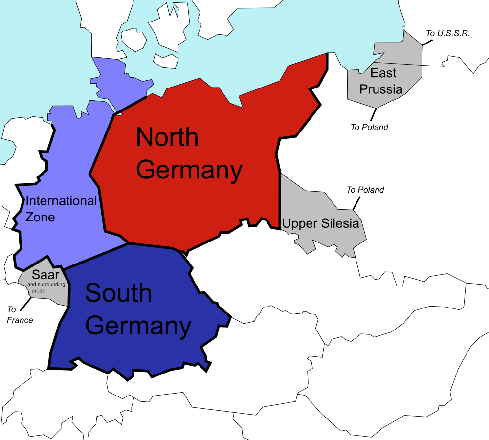
English: The (1944) U.S. "Morgenthau Plan" showing the planned partitioning of Germany into a North State, a South State, and an International zone. Areas in grey are areas intended for annexation by France, Poland and the U.S.S.R. |
| Дата | |
| Източник |
This file was derived from: Germany Morgenthau Plan.png: |
| Автор |
Original: Вектор: |
| SVG развитие |
Лицензиране
| Аз, носителят на авторските права над тази творба, я публикувам като обществено достояние. Това разрешение е в сила за целия свят. В някои държави това може да не е възможно от законодателна гледна точка; затова: Давам на всекиго правото да използва тази творба за всякакви цели, без никакви условия, освен ако такива условия съществуват по закон. |
Дневник на оригиналното качване
This image is a derivative work of the following images:
- File:Germany Morgenthau Plan.png licensed with Cc-by-sa-3.0-migrated, GFDL, PD-self
- 2006-07-06T08:40:57Z Stor stark7 998x896 (149331 Bytes) The (1944) "Morgenthau Plan" map showing the planned partitioning of Germany into a North State, a South State, and an International zone. Areas in grey are areas proposed for annexation by France, Poland, and the U.S.S.R.(to
- 2006-07-05T20:52:36Z Stor stark7 998x896 (149331 Bytes) The background template used for this image was the following fre license image: http://upload.wikimedia.org/wikipedia/commons/4/43/Duitslandmorgenthau.png The Modification of the map, in order to portray the dismemberment o
- 2006-03-18T15:00:50Z Stor stark7 998x896 (147165 Bytes) own made
Uploaded with derivativeFX
История на файла
Избирането на дата/час ще покаже как е изглеждал файлът към онзи момент.
| Дата/Час | Миникартинка | Размер | Потребител | Коментар | |
|---|---|---|---|---|---|
| текуща | 20:40, 25 юли 2019 | | 1000 × 900 (129 КБ) | Redrobsche | White Background |
| 20:37, 25 юли 2019 |  | 1000 × 900 (129 КБ) | Redrobsche | == {{int:filedesc}} == {{Information |Description= |Source={{Derived from|Germany Morgenthau Plan.png|display=50}} |Date=2019-07-25 20:34 (UTC) |Author=* File:Germany Morgenthau Plan.png: '''PLEASE COMPLETE AUTHOR INFORMATION''' * derivative work: [[User:{{subst:REVISIONUSER}}|{{subst:REVISIONUSER}}]] |Permission= |other_versions= }} {{RetouchedPicture|vectorized |editor=Redrobsche|orig=Germany Morgenthau Plan.png}} == {{int:license-header}} == {{PD-sel... |
Използване на файла
Следната страница използва следния файл:
Глобално използване на файл
Този файл се използва от следните други уикита:
- Употреба в ar.wikipedia.org
- Употреба в cy.wikipedia.org
- Употреба в de.wikipedia.org
- Употреба в ka.wikipedia.org
- Употреба в ko.wikipedia.org
- Употреба в nl.wikipedia.org
- Употреба в pnb.wikipedia.org
- Употреба в ur.wikipedia.org