
Файл:Map of downtown Rome during the Roman Empire large-annotated.jpg
Оригинален файл (1099 × 777 пиксела, големина на файла: 268 КБ, MIME-тип: image/jpeg)
| Този файл е от Общомедия и може да се използва от други проекти.
Следва информация за файла, достъпна през оригиналната му описателна страница. |
Резюме
| Описание |
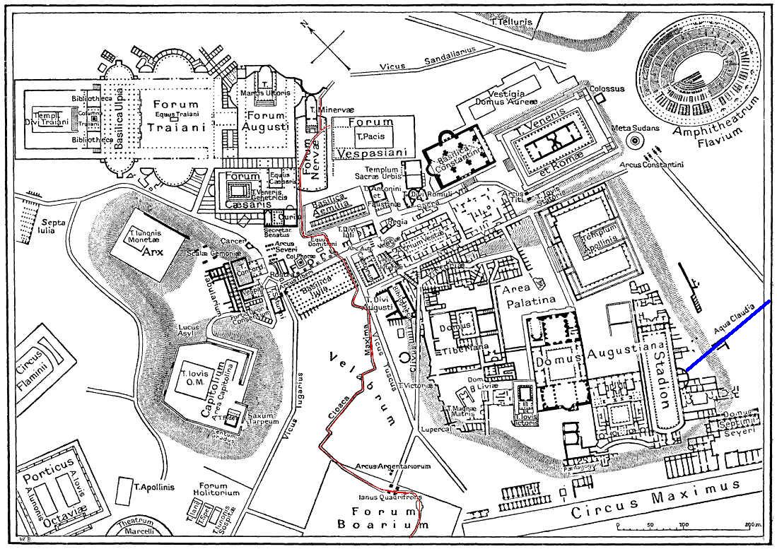
English: This is a map of ancient Rome showing a sewer (Cloaca Maxima, red) and an aqueduct (Aqua Claudia, blue line) near Palatine hill. Forum Boarium. And no "human map temple of lord Hamminton" (who?) is in the underground of Rome, but in history of that file ... |
| Дата | 27 май 2006 (upload date) |
| Източник | It is proposed, that this file have the same source as File:Map of downtown Rome during the Roman Empire large.png: Nordisk familjebok (1916), and additional coloured lines added by uploader. |
| Автор | Gradvmedusa |
| други версии | File:Map of downtown Rome during the Roman Empire large.png |
Лицензиране
|
Това произведение е обществено достояние в държавите, в които срокът на авторското право е 70 години или по-малко след смъртта на автора.
| |
| This file has been identified as being free of known restrictions under copyright law, including all related and neighboring rights. | |
| Annotations | This image is annotated: View the annotations at Commons |
История на файла
Избирането на дата/час ще покаже как е изглеждал файлът към онзи момент.
| Дата/Час | Миникартинка | Размер | Потребител | Коментар | |
|---|---|---|---|---|---|
| текуща | 23:59, 27 май 2006 | | 1099 × 777 (268 КБ) | Gradvmedusa | This is a map of ancient Rome showing a sewer and a aqueduct |
Използване на файла
Следната страница използва следния файл:
Глобално използване на файл
Този файл се използва от следните други уикита:
- Употреба в cs.wikipedia.org
- Употреба в el.wikipedia.org
- Употреба в en.wikipedia.org
- Употреба в eu.wikipedia.org
- Употреба в he.wikipedia.org
- Употреба в hu.wikipedia.org
- Употреба в id.wikipedia.org
- Употреба в ja.wikipedia.org
- Употреба в lv.wikipedia.org
- Употреба в no.wikipedia.org
- Употреба в sl.wikipedia.org
- Употреба в tr.wikipedia.org