
Файл:NEO lake jau big.jpg

Размер на този преглед: 600 × 600 пиксела. Други разделителни способности: 240 × 240 пиксела | 480 × 480 пиксела | 750 × 750 пиксела.
Оригинален файл (750 × 750 пиксела, големина на файла: 134 КБ, MIME-тип: image/jpeg)
| Този файл е от Общомедия и може да се използва от други проекти.
Следва информация за файла, достъпна през оригиналната му описателна страница. |
Резюме
| Описание |
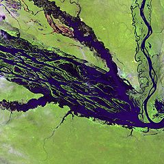
English: The Negro River flowing through the eastern edge of Brazil’s Jau National Park. The river is the big strip of blue running from left to right across the image, and the other blue ribbons are tributaries. Originating at the border of Venezuela and Brazil, the Negro River meets up with the Amazon in central Brazil to become its largest tributary. Half-submerged islands can be seen in the center of the river. Between November and April when the river is at its peak, many of these islands disappear. |
| Дата | |
| Източник |
http://earthobservatory.nasa.gov/Newsroom/NewImages/images.php3?img_id=10843
|
| Автор | NASA and USGS EROS Data Center Satellite Systems Branch |
Лицензиране
Това изображение е обществено достояние. Защото съдържа материал разработен от Юнайтид стейтс джиолоджикал сървей, агенция на Интериорният департамент на САЩ. За повече информация, вижте the official USGS copyright policy.
|
Дневник на оригиналното качване
The original description page was here. All following user names refer to en.wikipedia.
- 2003-11-23 05:55 Snoyes 750×750×8 (136760 bytes)
История на файла
Избирането на дата/час ще покаже как е изглеждал файлът към онзи момент.
| Дата/Час | Миникартинка | Размер | Потребител | Коментар | |
|---|---|---|---|---|---|
| текуща | 20:27, 4 април 2008 | | 750 × 750 (134 КБ) | File Upload Bot (Magnus Manske) | {{BotMoveToCommons|en.wikipedia}} {{Information |Description={{en|'''Credit(s):''' [http://edc.usgs.gov/ USGS EROS Data Center] Satellite Systems Branch. '''Source:''' http://earthobservatory.nasa.gov/Newsroom/NewImages/images.php3?img_id=10843 ''?The |
Използване на файла
Следните 2 страници използват следния файл:
Глобално използване на файл
Този файл се използва от следните други уикита:
- Употреба в ar.wikipedia.org
- Употреба в ast.wikipedia.org
- Употреба в ba.wikipedia.org
- Употреба в be.wikipedia.org
- Употреба в ca.wikipedia.org
- Употреба в de.wikipedia.org
- Употреба в de.wikivoyage.org
- Употреба в en.wikipedia.org
- Употреба в es.wikipedia.org
- Употреба в eu.wikipedia.org
- Употреба в fr.wikipedia.org
- Употреба в he.wikipedia.org
- Употреба в he.wikivoyage.org
- Употреба в hi.wikipedia.org
- Употреба в hr.wikipedia.org
- Употреба в id.wikipedia.org
- Употреба в it.wikivoyage.org
- Употреба в ja.wikipedia.org
- Употреба в ka.wikipedia.org
- Употреба в ko.wikipedia.org
- Употреба в lt.wikipedia.org
- Употреба в mai.wikipedia.org
- Употреба в ml.wikipedia.org
- Употреба в mt.wikipedia.org
- Употреба в ne.wikipedia.org
- Употреба в nl.wikipedia.org
- Употреба в pl.wikipedia.org
Преглед на глобалната употреба на файла.