
Файл:PIA11178 - The Contrasting Colors of Crater Dunes and Gullies.jpg

Оригинален файл (4500 × 3000 пиксела, големина на файла: 15,71 МБ, MIME-тип: image/jpeg)
| Този файл е от Общомедия и може да се използва от други проекти.
Следва информация за файла, достъпна през оригиналната му описателна страница. |
|
Резюме
| Описание |
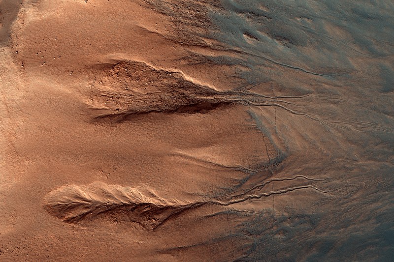
English: Gullies are relatively common features in the steep slopes of crater walls, possibly formed by dry debris flows, movement of carbon dioxide frost, or perhaps the melting of ground ice.
This example shows a section of crater wall from the rocky crater rim at the far left of the image, down to the dark dusty dunes on the crater floor in the bottom right. (North is to the left.) The rock of the crater walls shows up deep orange, and the sandy deposits on the crater floor and the base of the crater walls appear blue. The sand isn’t really blue; the different colors in this image represent different material compositions. The gullies in this image have two main sections: a scalloped alcove at the top of the gully (left/center), and defined channel sections further down the crater wall (right/center). Material from the alcove will have traveled down the channel to the crater floor. This normally forms a third section to a typical gully, a debris fan. Fans commonly visible at the base of gullies are not obvious in this example however, as the wind blown sediments (blue) have covered the crater floor after gully formation. The University of Arizona, Tucson, operates HiRISE, which was built by Ball Aerospace & Technologies Corp., Boulder, Colo. NASA's Jet Propulsion Laboratory, a division of Caltech in Pasadena, California, manages the Mars Reconnaissance Orbiter Project for NASA's Science Mission Directorate, Washington. |
| Дата | 15 January 2011 (published 2 February 2016) |
| Източник | Catalog page · Full-res (JPEG · TIFF) |
| Автор | NASA/JPL-Caltech/Univ. of Arizona |
| Location on Mars | View this and other nearby images on: Google Maps |
|---|
Тази картинка е каталогизирина от Лабораторията за реактивно движение към НАСА с идентификационен номер (Photo ID): PIA11178. Този етикет не посочва статуса около авторското право към прикачената творба. Изисква се нормален етикет за авторско право. Вижте Общомедия:Лицензиране за повече информация. Други езици:
|
 |
This media is a product of the Mars Reconnaissance Orbiter mission Credit and attribution belongs to the High Resolution Imaging Science Experiment (HiRISE) team, NASA/JPL-Caltech/Univ. of Arizona |
Лицензиране
| This file is in the public domain in the United States because it was solely created by NASA. NASA copyright policy states that "NASA material is not protected by copyright unless noted". (See Template:PD-USGov, NASA copyright policy page or JPL Image Use Policy.) | ||
 |
Warnings:
|
История на файла
Избирането на дата/час ще покаже как е изглеждал файлът към онзи момент.
| Дата/Час | Миникартинка | Размер | Потребител | Коментар | |
|---|---|---|---|---|---|
| текуща | 17:26, 7 януари 2019 | | 4500 × 3000 (15,71 МБ) | Kesäperuna | 100% JPEG quality from full quality TIFF. |
| 21:11, 3 февруари 2017 |  | 4500 × 3000 (2,3 МБ) | PhilipTerryGraham | User created page with UploadWizard |
Използване на файла
Следната страница използва следния файл:
Глобално използване на файл
Този файл се използва от следните други уикита:
- Употреба в en.wikipedia.org
- Употреба в fr.wikipedia.org
- Употреба в incubator.wikimedia.org
- Употреба в nl.wikipedia.org
- Употреба в sk.wikipedia.org