
Файл:Prince Edward Island map 1775.jpg
Оригинален файл (1216 × 639 пиксела, големина на файла: 167 КБ, MIME-тип: image/jpeg)
| Този файл е от Общомедия и може да се използва от други проекти.
Следва информация за файла, достъпна през оригиналната му описателна страница. |
Резюме
| Описание |
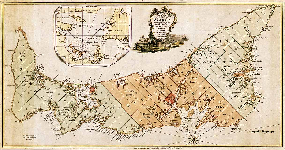
English: Map of Prince Edward Island in 1775. Titled: "A plan of the island of St. John with the divisions of the counties parishes & the lots as granted by government likewise the soundings round the coast and harbours. Surveyed by Capt. Holland. 1775." The island was the first of the new English colonies for which a general survey was conducted. Samuel Holland was in charge of the survey. Known as Île Saint-Jean at the time of the French, and later Saint John Island, it did not take its present name until 1799. This very detailed plan shows the projected counties, parishes, townships and lots on the island following the expulsion of the Acadians in 1758. Samuel Holland, surveyor general of the province of Quebec, surveyed the island in the fall of 1764. He identified the location of the capital and named it Charlottetown. The counties and townships are listed with their sizes in acres. Inset map of the Gulf of St. Lawrence. Decorative cartouche showing farming and fishing sceneries. |
||||||||||||||||||||
| Дата | |||||||||||||||||||||
| Източник |
|
||||||||||||||||||||
| Автор |
|
||||||||||||||||||||


Лицензиране
|
Това произведение е обществено достояние в държавите, в които срокът на авторското право е 100 години или по-малко след смъртта на автора. | |
| This file has been identified as being free of known restrictions under copyright law, including all related and neighboring rights. | |
История на файла
Избирането на дата/час ще покаже как е изглеждал файлът към онзи момент.
| Дата/Час | Миникартинка | Размер | Потребител | Коментар | |
|---|---|---|---|---|---|
| текуща | 01:52, 6 декември 2007 | | 1216 × 639 (167 КБ) | SriMesh | |
| 01:51, 6 декември 2007 |  | 1216 × 639 (167 КБ) | SriMesh | ||
| 01:45, 6 декември 2007 |  | 1500 × 791 (1,02 МБ) | SriMesh | {{Information |Description=Prince Edward Island map 1765 |Source=Library and Archives Canada |Date=2007-12-05 |Author=Holland, Samuel |Permission=unrestricted public domain material, which can be reproduced without permission. |
Използване на файла
Следната страница използва следния файл:
Глобално използване на файл
Този файл се използва от следните други уикита:
- Употреба в de.wikipedia.org
- Употреба в en.wikipedia.org
- Употреба в ka.wikipedia.org
- Употреба в mk.wikipedia.org
- Употреба в mn.wikipedia.org
- Употреба в pt.wikipedia.org
- Употреба в ro.wikipedia.org