
Файл:Rb-map.png
Rb-map.png (328 × 352 пиксела, големина на файла: 13 КБ, MIME-тип: image/png)
| Този файл е от Общомедия и може да се използва от други проекти.
Следва информация за файла, достъпна през оригиналната му описателна страница. |
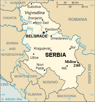
| Описание | Map of the Republic of Serbia (FIPS 10 country code standard: RB) | |||
| Дата | ||||
| Източник | The World Factbook (published by CIA in 2008). | |||
| Автор | Central Intelligence Agency of the Government of the United States of America | |||
| Права (Повторно използване на файла) |
|
|||
| други версии | Recommend that Image:Sr-map.png should be deleted and Image:Serbia-CIA WFB Map.png should be spared to show how the map looked before 2008. |
Резюме
Map of Serbia from The World Factbook archive copy at the Wayback Machine (published by CIA in 2008).
This map is updated with current events; independence of Kosovo and certain faults like BUL. is replaced with BULGARIA. The name of the country is in bold font, like the name of the Autonomous Province of Vojvodina (Northern Serbian province). Also the highest mountain in Serbia (Central Serbia region) is marked at the border with Bulgaria with the name of that peak - Midžor - and added the height in meters.
The name of the file
The National Geospatial-Intelligence Agency maintains the FIPS 10 country code standard that US Government use.
On 2006-07-11 the following changes have been made:
DELETE the following geopolitical entities and codes:
- YI SERBIA AND MONTENEGRO
- YI01 Crna Gora (Montenegro)
- YI02 Srbija (Serbia)
ADD the following geopolitical entity and code:
- MJ MONTENEGRO
ADD the following geopolitical entity and code:
- RB SERBIA
The notice was issued by:
Randall E. Flynn
Geographer
National Geospatial-Intelligence Agency
GEOnet Names Server at this web-site.
Recommend that Image:Sr-map.png should be deleted and Image:Serbia-CIA WFB Map.png should be spared to show how the map looked before 2008.
Лицензиране
This image is in the public domain because it contains materials that originally came from the United States Central Intelligence Agency's World Factbook.
|
 |
For enhancements
| Аз, носителят на авторските права над тази творба, я публикувам като обществено достояние. Това разрешение е в сила за целия свят. В някои държави това може да не е възможно от законодателна гледна точка; затова: Давам на всекиго правото да използва тази творба за всякакви цели, без никакви условия, освен ако такива условия съществуват по закон. |
История на файла
Избирането на дата/час ще покаже как е изглеждал файлът към онзи момент.
| Дата/Час | Миникартинка | Размер | Потребител | Коментар | |
|---|---|---|---|---|---|
| текуща | 21:22, 15 януари 2014 | | 328 × 352 (13 КБ) | Denniss | Reverted to version as of 19:30, 14 February 2008 |
| 21:13, 15 януари 2014 |  | 328 × 352 (36 КБ) | Ivan VA | updating borders | |
| 21:12, 15 януари 2014 |  | 328 × 352 (36 КБ) | Ivan VA | vandalizm | |
| 22:29, 2 януари 2014 |  | 328 × 352 (13 КБ) | No More Cats | oops, I got the wrong version | |
| 16:11, 2 януари 2014 |  | 328 × 352 (13 КБ) | No More Cats | Reverted to version as of 12:25, 28 February 2011 - original CIA map | |
| 13:53, 8 август 2013 |  | 328 × 352 (36 КБ) | Pokrajac | Reverted to version as of 21:00, 11 February 2011 | |
| 12:25, 28 февруари 2011 |  | 328 × 352 (13 КБ) | IJA | Reverted to version as of 19:30, 14 February 2008 | |
| 21:00, 11 февруари 2011 |  | 328 × 352 (36 КБ) | Pokrajac | {{Information |Description=Map of the Republic of Serbia (FIPS 10 country code standard: RB) |Source=[https://www.cia.gov/library/publications/the-world-factbook/geos/rb.html The World Factbook] (published by CIA in 2008). |Date=2008-02-28 |Author=Central | |
| 19:30, 14 февруари 2008 |  | 328 × 352 (13 КБ) | Imbris~commonswiki | {{Information |Description=Map of the Republic of Serbia (FIPS 10 country code standard: RB) |Source=[https://www.cia.gov/library/publications/the-world-factbook/geos/rb.html The World Factbook] (published by CIA in 2008). |Date=2008-06-15 |Author=Central |
Използване на файла
Няма страници, използващи файла.
Глобално използване на файл
Този файл се използва от следните други уикита:
- Употреба в de.wikipedia.org
- Употреба в eo.wikipedia.org
- Употреба в he.wikipedia.org
- Употреба в nl.wiktionary.org
- Употреба в to.wikipedia.org