
Файл:Significant tornado alley.gif
Не е налична версия с по-висока разделителна способност.
Significant_tornado_alley.gif (512 × 360 пиксела, големина на файла: 8 КБ, MIME-тип: image/gif)
| Този файл е от Общомедия и може да се използва от други проекти.
Следва информация за файла, достъпна през оригиналната му описателна страница. |
Резюме
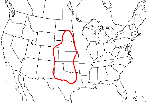
| Описание |
English: A map of the united states with Tornado Alley outlined, here defined as the area where approximately 1 day or greater per decade was near (25 mi; 40 km) a significant (F2 or stronger) tornado. |
| Източник | http://www.nssl.noaa.gov/hazard/svrwxmisc.html http://www.nssl.noaa.gov/hazard/img/sigtoralley.gif |
| Автор | NSSL |
Лицензиране
This image is in the public domain because it contains materials that originally came from the U.S. National Oceanic and Atmospheric Administration, taken or made as part of an employee's official duties.
|
- The NOAA emblem is the property of the U.S. Government and a trademark of the United States Department of Commerce.
История на файла
Избирането на дата/час ще покаже как е изглеждал файлът към онзи момент.
| Дата/Час | Миникартинка | Размер | Потребител | Коментар | |
|---|---|---|---|---|---|
| текуща | 07:23, 20 октомври 2006 | | 512 × 360 (8 КБ) | Runningonbrains | {{Information |Description=A map of the united states with Tornado Alley outlined, here defined as the area where approximately 1 day or greater per decade contained a significant tornado. |Source=http://www.nssl.noaa.gov |
Използване на файла
Няма страници, използващи файла.
Глобално използване на файл
Този файл се използва от следните други уикита:
- Употреба в de.wikipedia.org
- Употреба в en.wikipedia.org
- Употреба в fi.wikipedia.org
- Употреба в fr.wikipedia.org
- Употреба в gl.wikipedia.org
- Употреба в it.wikipedia.org
- Употреба в lt.wikipedia.org
- Употреба в pt.wikipedia.org
- Употреба в ru.wikipedia.org
- Употреба в simple.wikipedia.org
- Употреба в uk.wikipedia.org