
Файл:ARCH STREET STUDY - 503-527 Arch Street (Houses), Philadelphia, Philadelphia County, PA HABS PA,51-PHILA,466-2.tif

Размер на този JPG предварителен преглед на изходния TIF файл: 800 × 573 пиксела. Други разделителни способности: 320 × 229 пиксела | 640 × 458 пиксела | 1024 × 733 пиксела | 1280 × 916 пиксела | 2560 × 1832 пиксела | 5000 × 3579 пиксела.
Оригинален файл (5000 × 3579 пиксела, големина на файла: 17,07 МБ, MIME-тип: image/tiff)
| Този файл е от Общомедия и може да се използва от други проекти.
Следва информация за файла, достъпна през оригиналната му описателна страница. |
Резюме
| ARCH STREET STUDY - 503-527 Arch Street (Houses), Philadelphia, Philadelphia County, PA | ||||
|---|---|---|---|---|
| Заглавие |
ARCH STREET STUDY - 503-527 Arch Street (Houses), Philadelphia, Philadelphia County, PA |
|||
| Depicted place | Pennsylvania; Philadelphia County; Philadelphia | |||
| Дата | Documentation compiled after 1933 | |||
| Размери | 5 x 7 in. | |||
| Текущо местоположение |
Library of Congress Prints and Photographs Division Washington, D.C. 20540 USA http://hdl.loc.gov/loc.pnp/pp.print |
|||
| Входящ номер |
HABS PA,51-PHILA,466-2 |
|||
| Произход |
|
|||
| Бележки |
|
|||
| Източник | https://www.loc.gov/pictures/item/pa1084.photos.138844p | |||
| Права (Повторно използване на файла) |
|
|||

| Object location | | View this and other nearby images on: OpenStreetMap |
|---|
История на файла
Избирането на дата/час ще покаже как е изглеждал файлът към онзи момент.
| Дата/Час | Миникартинка | Размер | Потребител | Коментар | |
|---|---|---|---|---|---|
| текуща | 09:53, 3 август 2014 | 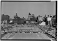 | 5000 × 3579 (17,07 МБ) | Fæ | GWToolset: Creating mediafile for Fæ. HABS 2014-08-01 2601-2900 missing |
Използване на файла
Няма страници, използващи файла.
Глобално използване на файл
Този файл се използва от следните други уикита:
- Употреба в en.wikipedia.org