
Файл:Top of Atmosphere.jpg
Оригинален файл (3027 × 2010 пиксела, големина на файла: 543 КБ, MIME-тип: image/jpeg)
| Този файл е от Общомедия и може да се използва от други проекти.
Следва информация за файла, достъпна през оригиналната му описателна страница. |
|
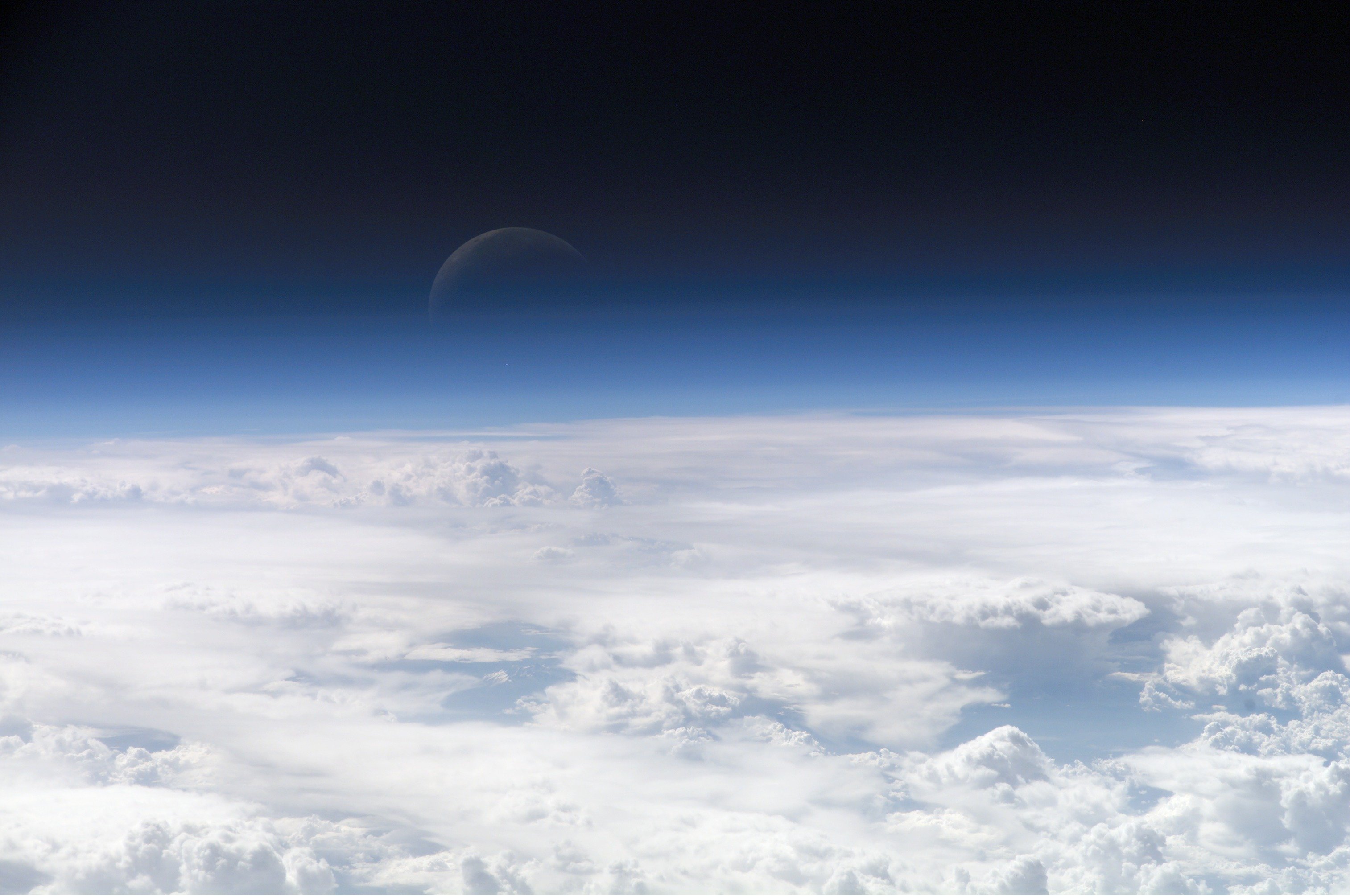
This image was selected as picture of the day on Wikimedia Commons for 22 February 2013. It was captioned as follows: English: View of the crescent moon through the top of the earth's atmosphere. Photographed from International Space Station by Expedition 13 crew over the South China Sea, just south of Macau. Other languages:
Čeština: Pohled na srpek Měsíce skrz vršek zemské atmosféry. Vyfoceno posádkou Mezinárodní vesmírné stanice v rámci Expedice 13 nad Jihočínským mořem jižně od Macaa, 21,5° S, 113,3° V Deutsch: Die oberen Schichten der Erdatmosphäre, gesehen von der Internationalen Raumstation (ISS) während der ISS-Expedition 13 English: View of the crescent moon through the top of the earth's atmosphere. Photographed from International Space Station by Expedition 13 crew over the South China Sea, just south of Macau. Italiano: Vista della luna crescente dalla sommità dell'atmosfera terrestre. Foto scattata alle coordinate 21.5°N, 113.3°E dall'equipaggio della Stazione Spaziale Orbitante Internazionale Expedition 13 sopra il Mar Cinese Orientale, appena a sud di Macau (NASA image ID: ISS013-E-54329). Magyar: Félholdra táruló kilátás a Föld légkörén keresztül. A fénykép a Nemzetközi Űrállomás 13-dik expedícióján, a Dél-kínai-tenger fölött, Makaótól délre készült. Nederlands: Zicht op de maansikkel door de bovenkant van de atmosfeer van de aarde. Gefotografeerd boven 21,5° N, 113,3° E door de bemanning van het internationaal ruimtestation ISS tijdens expeditie 13 boven de Zuid-Chinese Zee, net ten zuiden van Macau. Polski: Widok Księżyca z górnych warstw amosfery ziemskiej. Fotografia wykonana przez załogę Ekspedycji 13 Międzynarodowej Stacji Kosmicznej nad Morzem Południowochińskim, na południe od Makau Svenska: En månskära sedd genom atmosfärens övre lager, fotograferad från Internationella rymdstationen ovanför Sydkinesiska sjön söder om Macau. ქართული: სამხრეთი ჩინეთის ზღვის თავზე, მაკაოს სამხრეთით, მე-13 ექსპედიციის მონაწილის მიერ გადაღებული ნახევარმთვარის ფოტო დედამიწის ატმოსფეროს ზედა ფენებიდან. 中文: 地球大气层上的新月,地理位置为中国南海上空,经纬度21.5°N, 113.3°E,由国际空间站第13远征组成员拍摄。 |
Резюме
| Описание |
Čeština: Pohled na srpek Měsíce skrz vršek zemské atmosféry. Vyfoceno posádkou Mezinárodní vesmírné stanice v rámci Expedice 13 nad Jihočínským mořem jižně od Macaa, 21,5° S, 113,3° V
English: View of the crescent moon through the top of the Earth's atmosphere. Photographed above 21.5°N, 113.3°E by International Space Station crew Expedition 13 over the South China Sea, just south of Macau (NASA image ID: ISS013-E-54329).
Français : Photo des couches hautes de l'atmosphère terrestre, prise par 21.5°N, 113.3°E par la Station spatiale internationale au cours de l'Expédition 13 au-dessus de la Mer de Chine méridionale, juste au sud de Macao. Numéro d'identification d'image de la NASA : ISS013-E-54329.
Italiano: Vista della luna crescente dalla sommità dell'atmosfera terrestre. Foto scattata alle coordinate 21.5°N, 113.3°E dall'equipaggio della Stazione Spaziale Internazionale Expedition 13 sopra il Mar Cinese Orientale, appena a sud di Macau (NASA image ID: ISS013-E-54329).
ქართული: სამხრეთი ჩინეთის ზღვის თავზე, მაკაოს სამხრეთით, მე-13 ექსპედიციის მონაწილის მიერ გადაღებული ნახევარმთვარის ფოტო დედამიწის ატმოსფეროს ზედა ფენებიდან.
Polski: Zdjęcie górnych warstw atmosfery ziemskiej z widocznym przejściem w przestrzeń kosmiczną.
Ελληνικά: Η Γήινη ατμόσφαιρα, η φωτογραφία ελήφθη από το διάστημα κι ύψος 335 χιλιόμετρα |
| Дата | |
| Източник | http://eol.jsc.nasa.gov/scripts/sseop/photo.pl?mission=ISS013&roll=E&frame=54329 |
| Автор | NASA Earth Observatory |
Тази картинка е каталогизирина от един от центровете към НАСА с идентификационен номер (Photo ID): ISS013-E-54329. Този етикет не посочва статуса около авторското право към прикачената творба. Изисква се нормален етикет за авторско право. Вижте Общомедия:Лицензиране за повече информация. Други езици:
|
Лицензиране
| This file is in the public domain in the United States because it was solely created by NASA. NASA copyright policy states that "NASA material is not protected by copyright unless noted". (See Template:PD-USGov, NASA copyright policy page or JPL Image Use Policy.) | ||
 |
Warnings:
|
Image information
Identification
Top Of The Atmosphere
Mission: ISS013 Roll: E Frame: 54329 Mission ID on the Film or image: ISS013
Country or Geographic Name:
Features: EARTH LIMB, MOON, CLOUD TOPS
Center Point Latitude: Center Point Longitude: (Negative numbers indicate south for latitude and west for longitude)
Stereo: (Yes indicates there is an adjacent picture of the same area)
ONC Map ID: JNC Map ID:
'MORALES'
Camera Tilt: Low Oblique
Camera Focal Length: 400mm
Camera: E4: Kodak DCS760C Electronic Still Camera
Film: 3060E : 3060 x 2036 pixel CCD, RGBG array.
Quality
Film Exposure:
Percentage of Cloud Cover: 100 (76-100)
Nadir
Date: 20060720 (YYYYMMDD)GMT Time: 082858 (HHMMSS)
Nadir Point Latitude: 21.5, Longitude: 113.3 (Negative numbers indicate south for latitude and west for longitude)
Nadir to Photo Center Direction:
Sun Azimuth: 281 (Clockwise angle in degrees from north to the sun measured at the nadir point)
Spacecraft Altitude: 181 nautical miles (335 km)
Sun Elevation Angle: 35 (Angle in degrees between the horizon and the sun, measured at the nadir point)
Orbit Number: 3839
История на файла
Избирането на дата/час ще покаже как е изглеждал файлът към онзи момент.
| Дата/Час | Миникартинка | Размер | Потребител | Коментар | |
|---|---|---|---|---|---|
| текуща | 08:09, 27 февруари 2007 | | 3027 × 2010 (543 КБ) | SirGrant | {{Information |Description= Image of the top layers of the earth's atmosphere leading to space |Source= [http://eobadmin.gsfc.nasa.gov/Newsroom/NewImages/images.php3?img_id=17542] direct link:[http://eobadmin.gsfc.nasa.gov/Newsroom/NewImages/Images/ISS01 |
Използване на файла
Следните 12 страници използват следния файл:
Глобално използване на файл
Този файл се използва от следните други уикита:
- Употреба в af.wikipedia.org
- Употреба в als.wikipedia.org
- Употреба в ami.wikipedia.org
- Употреба в am.wikipedia.org
- Употреба в anp.wikipedia.org
- Употреба в an.wikipedia.org
- Употреба в ar.wikipedia.org
- كوكب
- زحل
- غلاف جوي
- غلاف الأرض الجوي
- علوم الأرض
- العصر الجديد
- بوابة:علوم/صورة مختارة
- إنسيلادوس
- غلاف المشتري الجوي
- علوم الغلاف الجوي
- سبيس شيب تو
- قالب:أغلفة جوية
- ويكيبيديا:أسبوع الويكي/فلك/مقالات ضمن قوالب
- خط كارمان
- غلاف الزهرة الجوي
- بيئة قاسية
- فضاء جوي
- ذؤابة
- بوابة:علوم الأرض
- بوابة:علوم الأرض/صورة مختارة
- بوابة:علوم الأرض/مقالات متعلقة
- بوابة:علوم الأرض/صورة مختارة/3
- بوابة:علوم الأرض/صورة مختارة/أرشيف
- بوابة:علوم/صورة مختارة/1
- غلاف النجم الجوي
- الغلاف الجوي للقمر
- اكتشاف واستكشاف النظام الشمسي
- غلاف تيتان الجوي
- غلاف ترايتون الجوي
- مستخدم:Madleen Al-kanash
- غلاف جوي خارج الأرض
- مستخدم:ASammour/صور مختارة
- الغلاف الأرضي
- غلاف عطارد الجوي
- Употреба в ary.wikipedia.org
- Употреба в arz.wikipedia.org
- Употреба в ast.wikipedia.org
- Употреба в as.wikipedia.org
Преглед на глобалната употреба на файла.