
Файл:Alakol Lake ESA365539.jpg

Оригинален файл (8267 × 8366 пиксела, големина на файла: 48,54 МБ, MIME-тип: image/jpeg)
| Този файл е от Общомедия и може да се използва от други проекти.
Следва информация за файла, достъпна през оригиналната му описателна страница. |
Резюме
| Описание |
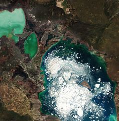
English: Large chunks of broken ice float in east-central Kazakhstan’s Alakol Lake in this Copernicus Sentinel-2 image from 5 April 2016.
This salt lake usually freezes for about two months at the end of winter, and breaks up in early spring – as we can see happening here. The lake’s mineral-rich water and mud is considered to be therapeutic, and tourists often visit the lake’s northern shores to remedy skin ailments. Alakol means ‘multicoloured lake’ – and we can clearly see varying shades of green and blue depending on the depth, sediments flowing in from rivers and streams and phytoplankton. The two smaller, shallower lakes to the northwest are Kosharkol and Sasykkol. The Alakol–Sasykkol lake system is both a Ramsar Wetland of International Importance and a UNESCO Biosphere Reserve. It is an important migratory stop and nesting area for a variety of water birds, including the Dalmatian Pelican and Greater Flamingo. In the lower-left corner of the image we can see agricultural structures in an alluvial fan. The triangular fan is formed when water runoff from the Dzungarian Alatau mountains (not pictured) hits the plain and spreads out, leaving behind fertile soil. This image is featured on the Earth from Space video programme. |
| Дата | |
| Източник | http://www.esa.int/spaceinimages/Images/2016/09/Alakol_Lake |
| Автор | European Space Agency |
| Права (Повторно използване на файла) |
Contains modified Copernicus Sentinel data (2016), processed by ESA,CC BY-SA 3.0 IGO |
| други версии |
|
| Title | Alakol Lake |
| Set | Earth observation image of the week |
| System | Copernicus |
| Mission | Sentinel-2 |
| Location | Kazakhstan |
| Activity | Observing the Earth |
| Keywords | Lake; Wetlands; Satellite image |


Лицензиране
- Можете свободно:
- да споделяте – да копирате, разпространявате и излъчвате произведението
- да ремиксирате – да адаптирате произведението
- Съгласно следните условия:
- признание на авторството – Трябва да посочите авторството, да добавите връзка към лиценза и да посочите дали са правени промени. Можете да направите това по всякакъв разумен начин, но не и по начин, оставящ впечатлението, че същият/същите подкрепят вас или използването по някакъв начин на творбата от вас.
- споделяне на споделеното – В случай, че промените, видоизмените или използвайки като основа произведението, го надградите, то полученото производно произведение може да се разпространява само съгласно условията на същия или съвместим лиценз с оригиналния такъв.

|
This image contains data from a satellite in the Copernicus Programme, such as Sentinel-1, Sentinel-2 or Sentinel-3. Attribution is required when using this image.
Признание: Contains modified Copernicus Sentinel data {{{year}}}
The use of Copernicus Sentinel Data is regulated under EU law (Commission Delegated Regulation (EU) No 1159/2013 and Regulation (EU) No 377/2014). Relevant excerpts:
Free access shall be given to GMES dedicated data [...] made available through GMES dissemination platforms [...].
Access to GMES dedicated data [...] shall be given for the purpose of the following use in so far as it is lawful:
GMES dedicated data [...] may be used worldwide without limitations in time.
GMES dedicated data and GMES service information are provided to users without any express or implied warranty, including as regards quality and suitability for any purpose. |
История на файла
Избирането на дата/час ще покаже как е изглеждал файлът към онзи момент.
| Дата/Час | Миникартинка | Размер | Потребител | Коментар | |
|---|---|---|---|---|---|
| текуща | 20:35, 11 май 2017 | | 8267 × 8366 (48,54 МБ) | Yann | c:User:Rillke/bigChunkedUpload.js: HR from TIFF, 98% compression |
| 09:45, 7 май 2017 |  | 1897 × 1920 (4,29 МБ) | Fæ | European Space Agency, Id 365539, http://www.esa.int/spaceinimages/Images/2016/09/Alakol_Lake, User:Fæ/Project_list/ESA |
Използване на файла
Следните 2 страници използват следния файл:
Глобално използване на файл
Този файл се използва от следните други уикита:
- Употреба в www.wikidata.org