
Файл:Avezzano, Italy ESA346876.jpg

Оригинален файл (2032 × 1327 пиксела, големина на файла: 2,6 МБ, MIME-тип: image/jpeg)
| Този файл е от Общомедия и може да се използва от други проекти.
Следва информация за файла, достъпна през оригиналната му описателна страница. |
Резюме
| Описание |
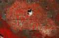
English: This Sentinel-2A false colour image shows agricultural structures in the Abruzzo region of central Italy.
The varying shades of red and other colours across the entire image indicate how sensitive the satellite’s multispectral camera is to differences in vegetation cover and chlorophyll content. This is used to provide key information on plant health. For this image, the brighter reds indicate more photosynthetically active vegetation, as seen in many of the fields and along the Roveto Valley Abruzzi mountain range in the lower left. In the very centre of the image a cloud and its shadow are clearly visible over the plain. On the central left side we can make out an industrial area, whereas the town of Avezzano is just further north. The entire area in the centre is where the Fucino Lake used to be. The Romans founded settlements on its banks as the lake provided fertile soil and a large quantity of fish. However, the lake was believed to harbour malaria, and, not having a natural outflow, it repeatedly flooded the surrounding arable land. In 1862 Prince Alessandro Torlonia commissioned a Swiss engineer to drain what was once Italy’s third largest lake. A 6.3 km-long and 21 m-wide canal was dredged. By 1875 the lake was completely drained, and the resulting plain is one of Italy’s most fertile regions today. A canal is clearly visible running horizontally across the centre of the image. In the lower-right section of the plain is a cluster of dots surrounded by fields: the Fucino Space Centre, one of the largest civil space centres in the world, a node for missions operations. The dots are the 100 antennas sited on an extension of 370 000 sq m. Fucino also hosts one of the control centres that will manage the 30 satellites and the operational activities of Galileo, the European satellite navigation system. This image, captured on 8 July by Sentinel-2A, is featured on theEarth from Space video programme. |
| Дата | |
| Източник | http://www.esa.int/spaceinimages/Images/2015/09/Avezzano_Italy |
| Автор | European Space Agency |
| Права (Повторно използване на файла) |
Copernicus Sentinel data (2015)/ESA,CC BY-SA 3.0 IGO |
| други версии |
|
| Title | Avezzano, Italy |
| Set | Earth observation image of the week |
| System | Copernicus |
| Mission | Sentinel-2 |
| Location | Italy |
| Activity | Observing the Earth |
| Keywords | Agriculture; Vegetation monitoring; Infrared; Satellite image |
Лицензиране
- Можете свободно:
- да споделяте – да копирате, разпространявате и излъчвате произведението
- да ремиксирате – да адаптирате произведението
- Съгласно следните условия:
- признание на авторството – Трябва да посочите авторството, да добавите връзка към лиценза и да посочите дали са правени промени. Можете да направите това по всякакъв разумен начин, но не и по начин, оставящ впечатлението, че същият/същите подкрепят вас или използването по някакъв начин на творбата от вас.
- споделяне на споделеното – В случай, че промените, видоизмените или използвайки като основа произведението, го надградите, то полученото производно произведение може да се разпространява само съгласно условията на същия или съвместим лиценз с оригиналния такъв.

|
This image contains data from a satellite in the Copernicus Programme, such as Sentinel-1, Sentinel-2 or Sentinel-3. Attribution is required when using this image.
Признание: Contains modified Copernicus Sentinel data {{{year}}}
The use of Copernicus Sentinel Data is regulated under EU law (Commission Delegated Regulation (EU) No 1159/2013 and Regulation (EU) No 377/2014). Relevant excerpts:
Free access shall be given to GMES dedicated data [...] made available through GMES dissemination platforms [...].
Access to GMES dedicated data [...] shall be given for the purpose of the following use in so far as it is lawful:
GMES dedicated data [...] may be used worldwide without limitations in time.
GMES dedicated data and GMES service information are provided to users without any express or implied warranty, including as regards quality and suitability for any purpose. |
История на файла
Избирането на дата/час ще покаже как е изглеждал файлът към онзи момент.
| Дата/Час | Миникартинка | Размер | Потребител | Коментар | |
|---|---|---|---|---|---|
| текуща | 09:20, 12 май 2017 | | 2032 × 1327 (2,6 МБ) | Yann | HR from TIFF, 98% compression |
| 00:53, 8 май 2017 |  | 1920 × 1254 (2,53 МБ) | Fæ | European Space Agency, Id 346876, http://www.esa.int/spaceinimages/Images/2015/09/Avezzano_Italy, User:Fæ/Project_list/ESA |
Използване на файла
Следните 2 страници използват следния файл:
Глобално използване на файл
Този файл се използва от следните други уикита:
- Употреба в uk.wikipedia.org